<?xml version="1.0" encoding="UTF-8"?>
<feed xmlns="http://www.w3.org/2005/Atom">
  <title type="text">Cleveland Historical</title>
  <updated>2026-08-21T20:27:58+00:00</updated>
  <generator uri="http://framework.zend.com" version="1.12.20">Zend_Feed_Writer</generator>
  <link rel="alternate" type="text/html" href="https://mail.clevelandhistorical.org/"/>
  <link rel="self" type="application/atom+xml" href="https://mail.clevelandhistorical.org/items/browse?output=rss2"/>
  <id>https://mail.clevelandhistorical.org/</id>
  <author>
    <name>Cleveland Historical</name>
    <uri>https://mail.clevelandhistorical.org</uri>
  </author>
  <link rel="hub" href="http://pubsubhubbub.appspot.com/"/>
  <entry>
    <title type="html"><![CDATA[Cleveland Centre: The Flats&#039; short-lived International Trade Center]]></title>
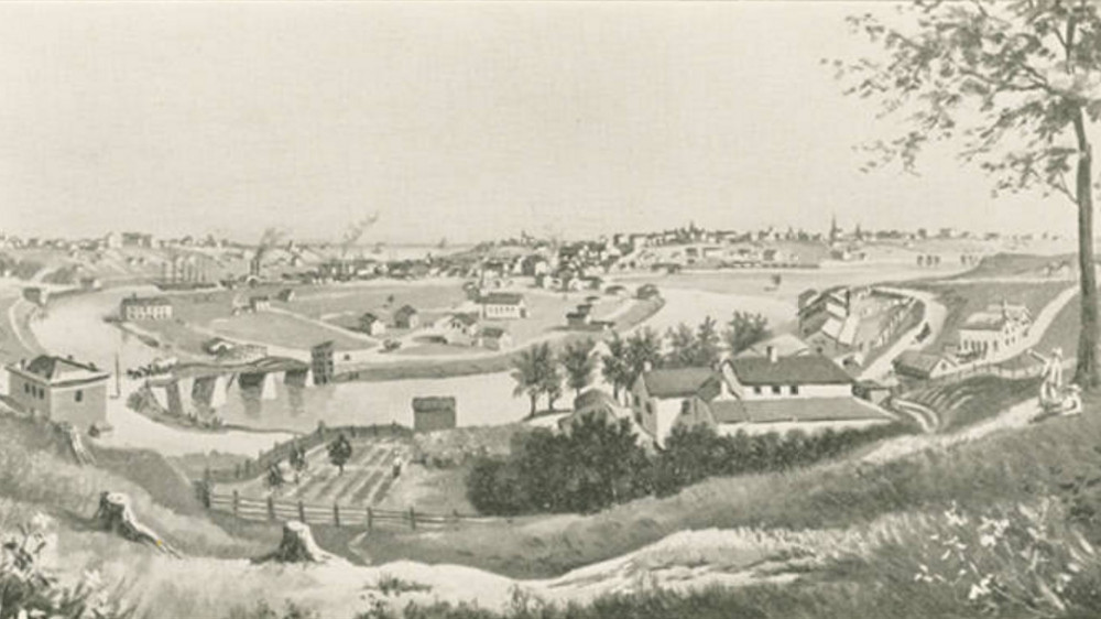
    <summary type="html"><![CDATA[<p><strong><em>The 1833 development proposal for Case's Point in the Flats featured streets named after foreign countries, all radiating from a hub called Gravity Place.  The hub's name was meant to signify that this place was destined to one day become the center of all Cleveland business and trade. Historian Samuel Peter Orth, looking back on the idea in 1910, called it "pretentious."  </em></strong></p><img src="https://mail.clevelandhistorical.org/files/fullsize/e8d97959e7f8530fcc7c404bd7e15696.jpg" alt="Cleveland Centre" /><br/><p>As the Ohio-Erie Canal, built between 1828 and 1832, was nearing completion, many in Cleveland caught "canal fever" and began to believe that their town was so strategically situated on the Great Lakes and along the new canal that it was destined to become an important world trade center.  One man who invested in that belief was James S. Clarke, the former Sheriff of Cuyahoga County and, in the decade of the 1830s, one of the biggest real estate speculators in Cleveland.  In 1831, Clarke, Richard Hilliard (a wealthy dry goods merchant), and Edmund Clark (an insurance agent and banker) formed a partnership and purchased fifty acres of land just south of the Village of Cleveland in Cleveland Township.  The acreage constituted the southern part of a peninsula surrounded on three sides by the Cuyahoga River and located just south of the river's first bend.  On this land, then known as Case's Point (but which today is a part of the Flats we know as Ox Bow Bend or Columbus Road Peninsula), the partnership platted a development in 1833 called "Cleveland Centre," which featured streets named after foreign countries—British, French, German, China and Russia—radiating from a hub called Gravity Place, an appropriate name, they thought, for a future center of world trade and business.  The land was ideally situated just south of the new Canal Basin, where Great Lakes ships traveling up the Cuyahoga River were expected to anchor and receive or transfer cargo to or from awaiting canal boats.  </p><p>Lots in the new development sold well in the early years and soon a small village sprouted at Cleveland Centre.  Commission merchant offices, warehouses and docks were built on the western side of the development, primarily on Merwin Street, where a young John D. Rockefeller got his first job as an accounting clerk years later.  On the east side of the development, a residential neighborhood formed around Columbus Street (today, Columbus Road), the main avenue running north-south through the Centre.  It wasn't long before there were so many Irish and German working-class immigrants living there that, in 1838, they built the first Roman Catholic church in Cleveland,  St. Mary's on the Flats.  Cleveland Centre also received a boost from Clarke's construction of the Columbus Street Bridge in 1835—the first permanent bridge across the Cuyahoga River at Cleveland—and in 1836 by the platting of Willeyville.  Another development by Clarke and others, Willeyville was located on land directly across the river from Cleveland Centre and connected to it by the Columbus Street Bridge.</p><p>Despite James S. Clarke's optimism and promotion, and the promising beginning in the decade of the 1830s, Cleveland Centre, which was annexed to Cleveland in 1835, did not become a center of international trade and business.  Instead, a national economic crisis—the Panic of 1837—intervened, ending "canal fever" in Cleveland and ruining James S. Clarke.  After the economy recovered, it was the Cleveland, Columbus and Cincinnati Railroad (CC&C), rather than international trade merchants, that arrived in Cleveland Centre.  In 1851, the CC&C purchased twelve acres of land on the south end of the Centre—almost one-quarter of the entire development—and there built an engine roundhouse and other maintenance and repair facilities for its trains.  The arrival of railroads here and elsewhere in Cleveland in this era coincided with the city's early industrial development, and in the years that followed a number of industrial buildings went up at Cleveland Centre, on or near the tracks of the railroad.  Sometimes, the construction of these buildings required that portions of the streets that radiated from Gravity Place be vacated, and this, over the years, damaged the beauty and symmetry of the original street plan.  The residential neighborhood on the east side of the development likewise suffered from the arrival of the railroad and the intense industrial development.  By 1880, St. Mary's had closed its doors and many of its former parishioners had moved out of the Flats.  </p><p>The name "Cleveland Centre" itself lost its cachet sometime in the late nineteenth century as the place became better known as just part of the industrial Flats.  When Cleveland experienced de-industrialization in the mid-twentieth century, Cleveland Centre, like the rest of the Flats, languished for several decades as a place of mostly closed factories and empty warehouses.  That began to turn around in the decade of the 1970s when the Flats experienced rebirth as a city entertainment district.  Cleveland Centre was not, in the early years of this rebirth, home to many of the entertainment venues, which tended to locate to the north, closer to the lake.  However, in the early twenty-first century, a number of acres in the southern part of the Centre, formerly owned by the CC&C Railroad and its successors, were re-purposed for recreational use and became home to the Commodore's Club Marina, the Cleveland Rowing Foundation and Cleveland Metroparks' Rivergate Park, which featured a skatepark and a riverside restaurant called Merwin's Wharf.  With Cleveland Centre becoming a trendy place once again, Dan Rothenfeld, a local artist, taking it all in and perhaps channeling the ghost of James S. Clarke, proposed in 2016 that historic markers be placed there and that the original radial streets and hub at Gravity Place be lighted so that both on the ground and from the air people could remember and commemorate this early era attempt to build an international trade center in the Flats.  And why not? It is not the first time that grand plans have been laid out at this place. </p><p><em><strong><a href="https://mail.clevelandhistorical.org/items/show/767">For more (including 12 images) view the original article</a></strong></em></p>]]></summary>
    <published>2016-09-12T19:55:39+00:00</published>
    <updated>2026-04-17T19:17:41+00:00</updated>
    <link rel="alternate" type="text/html" href="https://mail.clevelandhistorical.org/items/show/767"/>
    <id>https://mail.clevelandhistorical.org/items/show/767</id>
    <author>
      <name>Jim Dubelko</name>
    </author>
  </entry>
  <entry>
    <title type="html"><![CDATA[Stone Mad Pub]]></title>
    <summary type="html"><![CDATA[<img src="https://mail.clevelandhistorical.org/files/fullsize/434cfcf1a0fc989fbc3c6b1255ae0bc7.jpg" alt="Stone Mad Pub, Exterior" /><br/><p>Opened in 2008, Stone Mad Pub is the latest in a long tradition of saloons and bars located at 1306 West 65th Street. The history of the building speaks to the importance of these establishments within a community, and reflects the changes that the Detroit Shoreway neighborhood has experienced over the last century. </p><p>The building was constructed as a tavern and store house by Cleveland's <a href="https://clevelandhistorical.org/items/show/156">Leisy Brewing Company</a> in 1912. The construction of the bar coincided with a period of great success for the brewery. As Cleveland's largest brewery at the turn of the century, Leisy owned multiple taverns throughout the city. This was a common practice for breweries of the era. Saloon keepers generally paid rent at the first of the month and were billed weekly for beer and whiskey. Breweries established the prices, which were generally the same throughout all of their saloons. </p><p>The choice to build on West 65th was likely due to the rapidly growing working-class immigrant population in the neighborhood. The neighborhood surrounding the tavern was densely populated with Irish, Italian, and Romanian immigrants. At a time when boardinghouses were common -- and living quarters were cramped -- the saloon offered a space to socialize and relax. The saloon keepers, who could generally speak English, were important members of the ethnic community. They regularly acted as intermediaries between the immigrant population and government officials. Some establishments even acted as banks for their patrons. </p><p>While production for Leisy Brewing Company peaked in 1918, the Prohibition enacted between 1920-1933 quickly resulted in the brewery's downfall. The bar on 1306 West 65th Street, however, continued operation as a popular speakeasy of the time. What is now known as the Detroit Shoreway neighborhood was notorious for Romanian, Irish, and Italian bootleggers during the Prohibition. Oral histories from the neighborhood suggested that the speakeasy at 1306 was raided by the police one night, and that barrels of whiskey were cracked open and poured onto West 65th Street. Despite such displays, Prohibition had little effect on the alcohol consumption of Cleveland residents. It is estimated that whereas Cleveland had about 1,200 bars in 1919, by 1923 these had all been replaced by over 3,000 speakeasies. Even more common was the sale of liquor in neighborhoods by those with an entrepreneurial spirit, and the brewing and distilling of homemade beverages for personal use. </p><p>Following Prohibition, the bar on 1306 West 65th Street continued to reflect its place within an ethnic community. The establishment was operated through the 1950s by an Italian social club known as the Societa Operia Italiana di Mutuo Soccorso del West Side. Italian social clubs, which were generally made up of people from the same family or hometown, peaked in popularity during the 1930s and 1940s. With the effects of post World War II suburbanization and assimilation, these societies slowly lost their importance as social and recreational outlets. By the 1960s the establishment was known as the I & R Bar, or the Italian and Romanian Bar. Due to the continued decline in the presence of these ethnic communities in the surrounding neighborhood, the establishment became the R & A Lounge by the 1980s. </p><p>With the disappearance of commerce and industry from the area, the neighborhood began to show signs of physical deterioration. Through the efforts of community organizers and citizen action groups, the commercial district on West 65th Street and Detroit Avenue has been revitalized over the last three decades. Efforts to develop the area as a center for the arts are also well on their way. These changes in the neighborhood were both instigated by and helped foster a resurgence in the creation of locally operated businesses. As with much of the redevelopment that has occurred in Detroit Shoreway, Stone Mad Pub acknowledged and preserved the history of the area while creating an establishment that would also serve the needs of a rapidly changing neighborhood. The front bar was designed as a traditional Irish pub, while the dining room took on an Italian motif.</p><p><em><strong><a href="https://mail.clevelandhistorical.org/items/show/213">For more (including 5 images) view the original article</a></strong></em></p>]]></summary>
    <published>2011-06-01T17:36:46+00:00</published>
    <updated>2026-04-17T19:17:37+00:00</updated>
    <link rel="alternate" type="text/html" href="https://mail.clevelandhistorical.org/items/show/213"/>
    <id>https://mail.clevelandhistorical.org/items/show/213</id>
    <author>
      <name>Richard Raponi</name>
    </author>
  </entry>
  <entry>
    <title type="html"><![CDATA[Gordon Square Arcade: A District&#039;s Namesake]]></title>
    <summary type="html"><![CDATA[<img src="https://mail.clevelandhistorical.org/files/fullsize/180d212a73d010c18dffe0bfa2193fad.jpg" alt="The Gordon Square Arcade" /><br/><p>The Gordon Square Arcade opened to the public on April 8, 1921. The unique and massive structure quickly became the centerpiece of the Gordon Square commercial district, and a source of pride for the surrounding neighborhood. The monumental building was not only constructed to meet the needs of the community, but acted as a reflection of the neighborhood's growth into a commercial center. In part, the success and growth of Gordon Square, and the choice to build the arcade on the corner of West 65th and Detroit Avenue, was due to its location. Interurban and crosstown streetcars not only provided Clevelanders access to the Gordon Square area. It also attracted residents from the developing communities of Rocky River and Lakewood. </p><p>Construction of the arcade took about one year to complete, and cost $1,500,000. The Gordon Square Arcade and Community Building included a seventy-five room hotel, a seventy-five stall market, a pool and billiard room, the Capitol Theatre, seventy offices, thirty-one stores, a barber shop, and a restaurant. </p><p>The Gordon Square Arcade remained the heart of a healthy commercial district until the middle of the 20th century, when post war affluence and the construction of highways played their part in promoting a mass exodus of residents, businesses, and industry from the City of Cleveland to the suburbs. New waves of settlers into Cleveland would never again match the numbers of those leaving, and the population began to plummet. Businesses left behind vacant storefronts, factories moved away, and the commercial district slowly began to deteriorate. In what is now considered the Detroit Shoreway neighborhood, these changes culminated in the collapse of the Gordon Square Arcade's parapet onto West 65th Street in 1978.</p><p>Through the efforts of citizen groups and the Detroit Shoreway Community Development Organization, the Gordon Square Arcade was saved from demolition and rehabilitated. In the process, the arcade once again became the centerpiece of Gordon Square and helped reestablish the intersection of West 65h Street and Detroit Avenue as a commercial district. A symbol of the possibilities of urban redevelopment, the Gordon Square Arcade has become a model for efforts to revitalize the Detroit Shoreway neighborhood.</p><p><em><strong><a href="https://mail.clevelandhistorical.org/items/show/211">For more (including 7 images) view the original article</a></strong></em></p>]]></summary>
    <published>2011-06-01T17:35:11+00:00</published>
    <updated>2026-04-17T19:17:37+00:00</updated>
    <link rel="alternate" type="text/html" href="https://mail.clevelandhistorical.org/items/show/211"/>
    <id>https://mail.clevelandhistorical.org/items/show/211</id>
    <author>
      <name>Richard Raponi</name>
    </author>
  </entry>
  <entry>
    <title type="html"><![CDATA[Vineyards of Chateau Hough]]></title>
    <summary type="html"><![CDATA[<img src="https://mail.clevelandhistorical.org/files/fullsize/helenliggett-chateuhough-nov2010jpg_b2e7449aa6.jpg" alt="Chateau Hough, Nov. 2010" /><br/><p>The Hough neighborhood on Cleveland’s east side faced tough times over several decades, especially after the Hough Riots in 1966. Many homes had boarded or broken windows, empty lots abounded, and debris cluttered the streets. The condition  of Hough left the neighborhood vulnerable to violence, crime, and foreclosures. With the future of Hough in question, one man hoped to make a difference.</p><p>After serving prison time in the late 1990s, Cleveland native Mansfield Frazier re-evaluated his life choices, and wanted to give back to his hometown. Frazier created a non-profit, Neighborhood Solutions, Inc., and used his own money to form Chateau Hough in 2010. Located at the corner of East 66th and Hough Avenue, Chateau Hough occupies three former empty lots, now housing grape vineyards. One contributor to Chateau Hough was ReImagining Cleveland, a grant program that has provided funding for over 50 environmental projects located on vacant lots across the city. The community program, initiated by the predecessor to Cleveland Neighborhood Progress, was dedicated to reusing vacant lots for the community’s benefit. The program worked with the city to award Chateau Hough $15,000.</p><p>In order to be a part of the urban pioneer movement, Frazier took up residence across the street from the nascent vineyards. Frazier believed that Chateau Hough would help re-establish the black middle class. Chateau Hough’s main objective is to prevent at-risk youth from entering the criminal system, in what is called “pre-entry,” by giving them something to do after school. Former inmates and war veterans also serve as volunteers, working and pruning over 200 vines.</p><p>Along with its role in trying to address the conditions that often lead to incarceration, Chateau Hough’s main selling point is the abundance of grapes produced to make wine. Working with volunteers from the community, the vacant lots were first cleared of debris. Then, the grapevines were planted, along with stakes and wires for their support. </p><p>The vineyards grow two distinct kinds of grapes, which can survive the cold winters in Cleveland. These grapes are called the Traminette and Frontenac. Chateau Hough’s website offers descriptions of these grapes, including what type of flavor both produce. These grapes have so far made seven varied, contemporary wines. The success of the wines is evident; Chateau Hough won second place in the Great Geauga County Fair in 2014, and made news in both the New York Times Sunday magazine and Oprah Winfrey’s O magazine. The vineyard also grows shiitake mushrooms and strawberries. Chateau Hough is able to grow all this produce year-round despite Cleveland’s harsh winters by using what is called a biocellar.</p><p>According to biologist Jean Loria, biocellars are repurposed basements of old, abandoned homes that are remodeled into greenhouses. Chateau Hough began using biocellars in 2014, allowing produce to be grown during the colder seasons. Frazier and Loria worked together by using this technological advancement. The idea was to bring the neighborhood back into a positive light and generate more revenue.</p><p>In 2018, Neighborhood Solutions Inc. obtained a permit to sell the wines made at Chateau Hough. Although Mansfield Frazier died on October 9, 2021, at the age of 78, Chateau Hough remains a community anchor, offering wine tastings and other events and continuing to seek ways to honor Frazier's vision of mentoring at-risk youth and people returning after incarceration. </p><p><em><strong><a href="https://mail.clevelandhistorical.org/items/show/148">For more (including 5 images&#32;&amp;&#32;2 audio files) view the original article</a></strong></em></p>]]></summary>
    <published>2011-02-17T07:35:10+00:00</published>
    <updated>2026-04-17T19:17:37+00:00</updated>
    <link rel="alternate" type="text/html" href="https://mail.clevelandhistorical.org/items/show/148"/>
    <id>https://mail.clevelandhistorical.org/items/show/148</id>
    <author>
      <name>Michael Rotman&amp;#32;&amp;amp;&amp;#32;Katherine Gerchak</name>
    </author>
  </entry>
  <entry>
    <title type="html"><![CDATA[Gordon Square]]></title>
    <summary type="html"><![CDATA[<img src="https://mail.clevelandhistorical.org/files/fullsize/detroitshoreway-dscdo-w65th-and-detroit-shows-city-grill-nd_b3d18a7ea4.jpg" alt="West 65th Street and Detroit Avenue" /><br/><p>Located at the intersection of W. 65th Street and Detroit Avenue, Gordon Square is the historic commercial district of the Detroit Shoreway neighborhood.   As residential construction and industry grew along and away from Detroit Avenue following the turn of the 19th century, the Gordon Square commercial district emerged to meet the retail, recreational, and service needs of the surrounding community. The construction of the Gordon Square Arcade and Community Building symbolized the prominence of this bustling community. Encompassing an entire city block, the Gordon Square Arcade was the largest construction project to have taken place on the West Side at the time of its opening in 1921.  The arcade quickly became the heart of the Gordon Square commercial district.   </p><p><em><strong><a href="https://mail.clevelandhistorical.org/items/show/146">For more (including 6 images&#32;&amp;&#32;1 video) view the original article</a></strong></em></p>]]></summary>
    <published>2011-02-11T21:52:59+00:00</published>
    <updated>2026-04-17T19:17:37+00:00</updated>
    <link rel="alternate" type="text/html" href="https://mail.clevelandhistorical.org/items/show/146"/>
    <id>https://mail.clevelandhistorical.org/items/show/146</id>
    <author>
      <name>Richard Raponi</name>
    </author>
  </entry>
  <entry>
    <title type="html"><![CDATA[EcoVillage]]></title>
    <summary type="html"><![CDATA[<img src="https://mail.clevelandhistorical.org/files/fullsize/ecovillage-dscdo-rtasign-2010may14print_10f7ca284e.jpg" alt="EcoVillage RTA Sign" /><br/><p>Cleveland's EcoVillage is an urban redevelopment project that aims to create an economically and ecologically sustainable community within the Detroit Shoreway neighborhood.  The project was conceived by environmental groups in the mid 1990s to combat urban sprawl and outmigration from the city's core by creating an attractive, healthy living space.  Environmentally conscious, pedestrian-friendly designs for an urban village were integrated with efforts to promote diversity and community involvement.  The EcoVillage project has been led by the efforts of EcoCity Cleveland, an environmental group that merged in 2007 with the Cleveland Museum of Natural History to form the GreenCityBlueLake Institute, and the Detroit Shoreway Community Development Organization, a neighborhood development organization.  While part of a larger worldwide movement toward creating sustainable ecovillage communities, it is one of only a few projects to successfully be implemented in an urban environment.</p><p><em><strong><a href="https://mail.clevelandhistorical.org/items/show/120">For more (including 5 images&#32;&amp;&#32;1 video) view the original article</a></strong></em></p>]]></summary>
    <published>2011-01-05T21:50:13+00:00</published>
    <updated>2026-04-17T19:17:37+00:00</updated>
    <link rel="alternate" type="text/html" href="https://mail.clevelandhistorical.org/items/show/120"/>
    <id>https://mail.clevelandhistorical.org/items/show/120</id>
    <author>
      <name>Richard Raponi</name>
    </author>
  </entry>
  <entry>
    <title type="html"><![CDATA[Battery Park: The Postindustrial Transformation of an Eveready Plant]]></title>
    <summary type="html"><![CDATA[<img src="https://mail.clevelandhistorical.org/files/fullsize/batterypark-dscdo-batteryparkhomes-nd_6fdab5bd2e.jpg" alt="Battery Park Townhomes" /><br/><p>Battery Park is an urban redevelopment project in the Detroit Shoreway neighborhood located on W. 73rd Street and W. 76th Street. Laid out in a "U" shaped design, the $100 million development overlooks Edgewater Park and is surrounded by what has sometimes been dubbed the West Side's "Little Italy."  The upscale residential enclave was built on the site of the Eveready Battery Co.'s old Edgewater Plant, which originally opened in the 1890s. Canadian-born engineer Lewis Urry, who worked at the Edgewater Plant, invented the modern alkaline dry battery (which became branded much later as Energizer) in 1956 at Eveready's research center in Parma. The plant on the site of Battery Park produced batteries until the late 1980s and thereafter became a battery-testing facility manned by a much smaller workforce. The facility closed permanently in 1999. Battery Park is currently the largest housing development in the City of Cleveland.</p><p><em><strong><a href="https://mail.clevelandhistorical.org/items/show/118">For more (including 6 images&#32;&amp;&#32;1 audio file) view the original article</a></strong></em></p>]]></summary>
    <published>2011-01-05T14:19:47+00:00</published>
    <updated>2026-04-17T19:17:37+00:00</updated>
    <link rel="alternate" type="text/html" href="https://mail.clevelandhistorical.org/items/show/118"/>
    <id>https://mail.clevelandhistorical.org/items/show/118</id>
    <author>
      <name>Richard Raponi</name>
    </author>
  </entry>
</feed>
