<?xml version="1.0" encoding="UTF-8"?>
<feed xmlns="http://www.w3.org/2005/Atom">
  <title type="text">Cleveland Historical</title>
  <updated>2026-08-21T20:14:18+00:00</updated>
  <generator uri="http://framework.zend.com" version="1.12.20">Zend_Feed_Writer</generator>
  <link rel="alternate" type="text/html" href="https://mail.clevelandhistorical.org/"/>
  <link rel="self" type="application/atom+xml" href="https://mail.clevelandhistorical.org/items/browse?output=rss2"/>
  <id>https://mail.clevelandhistorical.org/</id>
  <author>
    <name>Cleveland Historical</name>
    <uri>https://mail.clevelandhistorical.org</uri>
  </author>
  <link rel="hub" href="http://pubsubhubbub.appspot.com/"/>
  <entry>
    <title type="html"><![CDATA[Randall Park Race Track: Making Cleveland&#039;s Horse-Racing Suburb]]></title>
    <summary type="html"><![CDATA[<img src="https://mail.clevelandhistorical.org/files/fullsize/b8cf76e6f00190a92668ddc9a41a3e24.jpg" alt="Harness Racing at Randall Park" /><br/><p>Most of Cleveland's suburban municipalities began as a residential or "bedroom" communities whose residents commuted into the city each weekday, and a few started as preexisting towns shaped by early trade and industry. But one suburb, North Randall, was born in an entirely unique way – as a destination for thoroughbred horse racing. The economic history and center of attraction for North Randall has been revamped repeatedly over the past century. From 1908 to present day, the village has been dominated by horse racing tracks, a mall, and now an Amazon fulfillment facility. However, the first track, Randall Park, and a second, Thistledown, uniquely positioned horse racing as the most important economic engine for North Randall. </p><p>The Randall Park race track was originally part of the Forest City Farm which was established by Christopher F. Emery in 1883 as a horse breeding farm. The land for the track was bought in 1905 by Youngstown entrepreneurs and was later acquired by Bert Shank. He later sold 100 acres north of Emery Road to William B. Chisholm for his Thistledown Farms which was Randall Park’s neighbor. The remaining land of that later became the village of North Randall which was established in 1908 with Bert Shank as the first mayor. The village established its major industry in the breeding and training of trotting horses during this time. The racecourse of Randall Park was situated on the southeastern side of the city of Cleveland and served the racing enthusiasts from across the city and region.</p><p>Randall Park started as a trotting track for harness racing in 1908, supplanting the much older Glenville Race Track that folded that same year. The park had a one-mile oval-shaped track and a furlong turf course inside the oval. It also featured an open-air grandstand and clubhouse, with the grandstand being able to seat 5,500 people and the clubhouse an additional 2,000 people. The track had stables with a capacity of 650 horses. The track was worth $250,000 and it hosted the Grand Circuit that occurred in 1909. The event, which attracted a massive crowd of 17,000, was won by Emery’s trotter which was driven by Mayor Bert Shank. </p><p>Randall Park and Thistledown, which originally opened in 1925, both suffered a series of difficulties in the 1930s and ’40s, including a devastating fire at Thistledown in 1944. Sustained success was elusive until after World War II, when they finally attained a more durable national reputation. The tracks’ schedules grew considerably, and they hosted ever larger crowds to see major races. Thoroughbred racing had replaced trotting (harness) races in popularity, and Randall Park had converted to thoroughbred races in 1939. In 1951, Randall Park received a major upgrade that included grandstand expansion and miniature lakes, hedges, and landscaping in the center of its oval. The Ohio Derby, first run in the 1870s in Cincinnati, moved to a newly rebuilt Thistledown in 1953 and then to Randall Park in 1961. </p><p>Later, the Randall Park property was finally purchased by Youngstown-based developer Edward DeBartolo who also had ownership to the nearby Thistledown track and decided to transfer Randall Park’s dates there. Once that was finalized, the Randall Park land was rezoned commercial, and DeBartolo turned it into a shopping center. The $175 million <a href="https://clevelandhistorical.org/items/show/711">Randall Park Mall</a> opened on August 11, 1976, with 2 million square feet, over 200 stores on two levels, a modern look with unique marble floors, and a distinct constructed interior. This shopping center was intended to change the structure of the community by developing North Randall into a “super city.” DeBartolo initiated projects to create residential communities in which people not only could live but could operate their businesses as well. It eventually became one of the world's largest shopping complexes. The mall had a great run but closed in 2009. Newer malls and lifestyle centers, including Beachwood Place, LaPlace, and Legacy Village, all opened within a few miles between 1978 and 2003, plundering business from Randall Park. Online shopping was another factor around the world as to why malls were closing. Also, as the 2000s progressed, consumer habits shifted away from department stores all together. The rise in crime rates in area also played a factor.
The village’s horse racing heritage entered a new phase in 2010 after the mall shut down, and it opened back up as a Thistledown Racino managed by an entertainment company. Businesses later began to fail as consumers lost the comfort in their safety to shop. It was reconstructed and later became an Amazon fulfillment center in 2018.</p><p><em><strong><a href="https://mail.clevelandhistorical.org/items/show/995">For more (including 13 images) view the original article</a></strong></em></p>]]></summary>
    <published>2022-11-30T22:50:18+00:00</published>
    <updated>2026-04-17T19:17:43+00:00</updated>
    <link rel="alternate" type="text/html" href="https://mail.clevelandhistorical.org/items/show/995"/>
    <id>https://mail.clevelandhistorical.org/items/show/995</id>
    <author>
      <name>Denzel Prince</name>
    </author>
  </entry>
  <entry>
    <title type="html"><![CDATA[Fairhill Road Village: A Unique Planned Community ]]></title>
    <summary type="html"><![CDATA[<p><strong><em>"It is seldom that an entire neighborhood packs its trunks and moves in a body," wrote <em>The Architectural Exhibitor</em> in April of 1929 about a group of neighbors living around Hessler Road. The enclave of creative professionals planned to move into a community of their design, giving way to a historic development that bridges Cleveland and Cleveland Heights and urban and suburban living.</em></strong></p><img src="https://mail.clevelandhistorical.org/files/fullsize/9caad50fe9b6e3d9b87b5fbdb316811b.jpg" alt="Fairhill Road Village" /><br/><p>Locally known as Belgian Village, Fairhill Road Village was listed on the National Register of Historic Places in 1990. Originally called Fairmount Place before the change of the development’s frontage road's name from Fairmount Road to Fairhill Road, the single-family homes combine detached and semi-detached dwellings. Today, thirteen homes comprise the Fairhill Road Village Historic District; five two-family semi-detached units built over the winter between 1929 and 1930 and three detached homes built intermittently in 1930, 1933, and 1971.
Fairhill recalls other planned communities built around the same time, notably Mayfair Lane in Buffalo, Sessions Village in Columbus, and the French Village in Philadelphia. All share the use of uniform architecture in a historic-revival style and semi-detached layout. Fairhill’s use of an unusually natural setting so close to an urban center allows it to be an exemplary model of this mode of building.</p><p>Standing on the abandoned debris created in the 1915 construction of the Fairmount Reservoir, Fairhill literally straddles the divide between urban and suburban by being built over the municipal boundary between Cleveland and Cleveland Heights. Architecturally Fairhill blends into its neighboring communities through historical revival architecture that evokes a common European heritage, a facet of suburban living. The development utilizes a style reflective of the Cotswold Hills District of England. The homes favor white varied stone and stucco with multiple gables and various recesses in the façade, creating the overall effect of an English hamlet appearing out of the forest.</p><p>The combination of shared and private space is central to Fairhill’s makeup. Originally planned as seventeen semi-detached homes by architect Antonio DiNardo, the eleven houses share a single drive with the dwellings facing a private park directly off Fairhill Road for shared use of the residents. The semi-detached units connect via their respective garages while service rooms above allow a more insular living space that looks onto private terraced gardens built at the edge of a ravine running through Ambler Park.</p><p>Landscape architect A. Donald Gray drove Fairhill’s development from conception to completion. Before moving to Cleveland, in 1920, Gray worked for The Olmsted Brothers landscape architecture firm under Frederick Law Olmsted Jr. Gray’s profession and his connections to the lauded firm show throughout Fairhill’s design.</p><p>The use of gardening to accentuate a site’s beauty and create natural boundaries was a key principle in Olmsted’s work and reflects in Fairhill’s balanced relationship between architecture and landscape. Each private terrace uses flower beds sparingly in order not to distract attention from the natural landscape. Decorative pools mirror the Doan Brook at the bottom of the ravine while simultaneously attracting birds into the garden. The additional planting of trees and shrubs at the front of the development creates a natural boundary between the homes and the roadway leading to the city.</p><p>The construction of Fairhill Road Village coincided with a culmination of development in suburban Cleveland before the Great Depression. By the end of the 1920s, Cleveland’s population had reached 900,000. The completion of the Union Terminal complex would mark Cleveland as a great American industrial center, with one of the tallest buildings in the country serving as a grand focal point for commuters going to and from their rapidly expanding suburban neighborhoods. Between 1919 and 1929 an average of 300 new homes were built annually in Shaker Heights. Literature and pamphlets were used like propaganda championing the single-family house on a large site and demonizing living close to vestiges of the city like factories, apartments, and minorities.</p><p>Nearby, John D. Rockefeller Jr. was developing the site of his family’s former country estate, <a href="https://clevelandhistorical.org/items/show/83">Forest Hill</a>, into another residential community. To promote his development, he mounted a large-scale advertising campaign in local papers that played on his bucolic childhood and promised to “revolutionize American standards of home construction” and ensure that “your neighbors are inevitably people of tastes in common with yours.”</p><p>In contrast to these commercial enterprises, Fairhill Road Village echoes the communal aspects of the Garden City Movement. Spearheaded by urban theorist Ebenezer Howard’s <em>Garden Cities of To-Morrow</em>, the Garden City attempted to alleviate the congestion of urban life by creating small, self-contained, and interconnected communities that would give residents access to the benefits of both urban and rural living while also making them stakeholders through communal ownership. Unlike Shaker Heights and Forest Hill, profit was not Fairhill’s concern. It started as a collaboration between creative professionals living on <a href="https://clevelandhistorical.org/items/show/829">Hessler Road</a> who wanted to move away from the frenzy of Cleveland towards the tranquility of Cleveland Heights while maintaining the cultural sophistication of urban life. Fairhill incorporated many of the ideas championed by the Garden City Movement through shared ownership, green space, and limited size.</p><p>The Fairmount Development Group, comprised of future residents of Fairhill, was formed to purchase and subdivide the property into individual lots. The company’s mission statement clearly outlined its objective “to get a group of interesting people to build semi-detached houses in the same style of architecture, to build these houses on small areas of land…” Through a co-op model, the residents of Fairhill pooled resources to procure the land on which to build their homes. This communal approach was unusual as shown by A. Donald Gray’s letter to architect H. O. Fullerton that showed the committee in charge of securing the loan at Cleveland Trust for the development of Fairhill was “skeptical” because the proposition “was a new idea to them.”</p><p>Inadequate finances and a lack of interested parties created an obstacle to the construction of Fairhill. To fill the appropriate number of building plots, the Fairmount Development Group members were enlisted to find interested people within their network. One Fairhill planner, J. T. Seavers, told Gray, “I’m putting it up to every family to get one more pronto, and we will not only be done but have a waiting list.”</p><p>A sense of urgency pervaded the building of Fairhill that correlated with the beginning of the Great Depression. <em>Cleveland Plain Dealer </em>business columnist, and original resident, John W. Love wrote on October 24, 1929, about his unease in Cleveland’s labor conditions amid a large building project. Love cited labor’s stable relationship with “the Vans” (<a href="https://clevelandhistorical.org/items/show/66">Van Sweringen brothers</a>) during the five-year construction of the Terminal complex as long as they didn’t “rock the canoe,” but that those agreements would end in the spring, and he urged the building to be completed before March 31 to avoid a potential strike. A week later, on Black Tuesday, he used the urgency of the telegram to communicate what must have been a growing sense of dread, writing, “Financial conditions [are] so extremely ominous that I doubt we ought to proceed with construction except with best possible guarantees of money and stability of contractor.” By April 1930, ten of the seventeen planned homes were completed in the spirit of DiNardo’s original plans if not in size.</p><p>The Great Depression crippled neighboring developments like Shaker Heights and Forest Hill. Donald Gray saw Fairhill’s innovative collaboration amongst its residents as a potential benefit in residential development during the Depression. In a letter to <em>The Ladies Home Journal, </em>Gray wrote of how the residents were able to lower the cost of building by sharing building materials because of Fairhill’s uniform style as well as sharing the expense of an architect. In a letter to <em>House Beautiful Magazine, </em>Gray stressed Fairhill’s merits, writing, “It seems to me that in these days of economy that the scheme has a great deal of interest to the general reader.” The letters show Gray’s belief in Fairhill’s social and economic benefits while demonstrating its adaptability to changing times.</p><p>The planned community allowed refuge for Cleveland’s white population to create enclaves amongst themselves. Fairhill’s co-op model and design reflected the intention to innovate in habitation, but not immune to the self-selective nativist sentiments prevalent in the 1920s. Fairhill’s formation of The Fairmount Road Association allowed members of the community to retain the social control that <em>The Architectural Exhibitor </em>alluded to in writing, “In every community, there are certain sections and sometimes individual streets to which people of kindred tastes and habits naturally gravitate.” To live, build, or sell in the development required the approval of three-fourths of the Association's trustees—a trustee was either the owner of a home or their spouse—allowing the residents to foster a social homogeneity in line with its times. Fairhill never fulfilled its objective as outlined in <em>The Architectural Exhibitor </em>of moving the original group of Hessler Road residents into a community of their design. Nevertheless, Fairhill proved to be the cross-section of creative, cultured, and professional people reflective of its origination on Hessler Road including Russell and Rowena Jelliffe, founders of Karamu House, retired movie star May Alison, and aforementioned John Love and A. Donald Gray.</p><p><em><strong><a href="https://mail.clevelandhistorical.org/items/show/987">For more (including 10 images) view the original article</a></strong></em></p>]]></summary>
    <published>2022-11-28T20:14:38+00:00</published>
    <updated>2026-04-17T19:17:42+00:00</updated>
    <link rel="alternate" type="text/html" href="https://mail.clevelandhistorical.org/items/show/987"/>
    <id>https://mail.clevelandhistorical.org/items/show/987</id>
    <author>
      <name>Robert Vroman</name>
    </author>
  </entry>
  <entry>
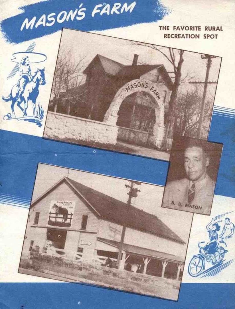
    <title type="html"><![CDATA[Mason&#039;s Farm: How an Ordinary Working Farm Became an Extraordinary Black Leisure Destination]]></title>
    <summary type="html"><![CDATA[<p><strong><em>The article <a href="https://greenbookcleveland.org/locations/cedar-country-club-masons-farm/">Mason's Farm</a> originally appeared in <a href="https://greenbookcleveland.org"><i>Green Book Cleveland</i></a>, our sister project exploring the history of Black entertainment, leisure, and recreation in Northeast Ohio. Named for its proprietor Benny Mason, Mason's Farm was a Black-owned working farm in Solon that achieved national renown as a music venue and resort in the 1930s-40s.</em></strong></p><img src="https://mail.clevelandhistorical.org/files/fullsize/208d4ec5c66d58b3c214bf1744dbf507.jpg" alt="Cover of Mason&#039;s Farm Booklet" /><br/><p>In 1935, Benjamin “Benny” Mason purchased a 160-acre farm in Solon on Cochran Road south of Route 43 and established what became known as “Mason’s Farm,” a popular resort, country club, and jazz venue. A well-known game operator, Mason purchased the farm and the Cedar Country Club subsequently opened in 1936. Upon the farm’s opening, Mason remarked, “I want to do something for my people. I want to make this farm a place where they can relax and enjoy themselves. I want to provide a place for them comparable to other races.” Despite its rural location beyond the east suburbs of Cleveland, one of the features Mason boasted was the Cedar Country Club's proximity to the city itself, claiming only a twenty-five-minute drive from Carnegie and East 55th Street in Cleveland. With the accessibility of the resort, both in location and its integrated clientele, the farm quickly became a popular destination for visitors across the country as well as Clevelanders. The Cedar Country Club gained national acclaim as the “showplace of Ohio.” The resort included furnished cabins, a restaurant, and nightclub. Some of its features included a riding academy, picnic grounds, and occasionally tours of the farm for students.</p><p>The Cedar Country Club also functioned as a nightclub and jazz venue that boasted popular artists Tiny Grimes, saxophonist Coleman Hawkins, and many others. The Cedar Country Club, which one <i>Call and Post</i> feature lauded as "Ohio's Swankiest Summer Resort," was routinely described as luxurious and enjoyed a listing in the 1939 edition of the <i>Negro Motorists' Green Book</i>. While it looked like a barn from the exterior, the clubhouse boasted a bar in the basement, another bar on the ground floor as well as a dance hall, and a lounge and private rooms on the second floor. It was available to be rented out for private parties, banquets, and other events. Mason renamed Cedar Country Club "Mason's Farm" in 1941 and hired restaurateur U. S. Dearing as manager. In addition to its leisure destination status, Mason’s Farm was also a working farm with more than 2,500 head of livestock and 145 of its 160 acres set aside for growing corn, wheat, and oats.</p><p>Mason himself was an eccentric character in Cleveland history, often running into legal trouble. Some of the allegations against him included purchasing stolen jewelry, transporting alcohol during Prohibition, and the frequent policy promoting that made Mason famous. Mason was known as the “king of policy games” as he notoriously ran illegal numbers rackets. In the summer of 1932, Benny Mason became the target of the Mayfield Road mob. In a number of attempts by the Mayfield Road mob to expand their own illegal numbers games into areas controlled by Mason, four men were arrested outside of Mason’s home and thought to be there to kill him.</p><p>Throughout his time both as a policy operator and owning the farm, Mason was notorious for “resigning” as the lead policy operator, but ultimately would move his operation’s headquarters and resume his business. Despite protests from management that claimed no gambling was permitted on the property, policy games continued to take place at the resort, making it a well-known gambling center in Cleveland. Residents in Solon in 1938 explained that while they did not see any “big-time gambling,” Mason’s Farm did have several slot machines. Though this reputation may have accounted for its disappearance from the <i>Green Book</i> after just one year, Mason's Farm remained very popular throughout the 1940s.</p><p>However, Mason redirected a significant portion of his wealth from these illicit games to support his community. Mason was known for his philanthropy, particularly for his donations to Black churches in Cleveland as well as paying educational costs for Black students. Throughout the early to mid-twentieth century across the country, policy and numbers games were cornerstones in providing economic opportunities to Black communities. Gambling rackets not only provided employment opportunities to Black residents in the community, but they also became a widespread source of investment into businesses and philanthropy. </p><p>Mason's establishment closed in 1951 and was sold to the Nickel Plate Railroad to form an industrial park. Benny Mason was involved in a fatal car crash in 1954 near London, Ohio, that took his life and the life of his friend Walter Woodford as well as critically injuring his wife Blanche.</p><p><em><strong><a href="https://mail.clevelandhistorical.org/items/show/967">For more (including 8 images) view the original article</a></strong></em></p>]]></summary>
    <published>2022-10-08T13:06:33+00:00</published>
    <updated>2026-04-17T19:17:42+00:00</updated>
    <link rel="alternate" type="text/html" href="https://mail.clevelandhistorical.org/items/show/967"/>
    <id>https://mail.clevelandhistorical.org/items/show/967</id>
    <author>
      <name>Cheyenne Florence</name>
    </author>
  </entry>
  <entry>
    <title type="html"><![CDATA[Ukrainian Village: Suburban Heir of a Tremont Legacy]]></title>
    <summary type="html"><![CDATA[<img src="https://mail.clevelandhistorical.org/files/fullsize/1e3d7fa8fe82aa3e7087cadc08140c50.jpg" alt="Ukrainian Village Sign" /><br/><p>When you leave Cleveland for the suburbs, perhaps the last thing you expect to find is a slice of another country nestled along the streets. In 2009, the suburban municipality of Parma to the southwest of Cleveland officially recognized its long-standing settlement of Ukrainians, giving them a "village" of their own. Ukrainian Village, located along a two-mile stretch of State Road, had been the vision of Ukrainian Americans since the 1940s. The rise of suburbs began to push them out of their original enclave in Cleveland’s Tremont neighborhood, setting the stage for the emergence of the vibrant community that is present today.  </p><p>In the late nineteenth century, immigrants of all walks of life arrived in Cleveland because of many different factors. Ukrainians were escaping political and economic hardships by coming to the United States, looking for work in any shape they could find. Ordinarily, they took up various jobs in Cleveland’s thriving industrial plants and mills. These jobs helped them to save money to send back to their relatives in the “old country.” They ended up establishing cultural and religious centers that have changed over time yet still stand as strong symbols of Ukrainian pride.   </p><p>Ukrainian settlement in Cleveland began in Tremont. The community began to put down roots in order to keep their memories and customs from home alive. The first of these Ukrainian institutions was the Saints Peter and Paul Ukrainian Church, built in 1910 on West 7th Street. Shortly after, St. Vladimir Church was also established in Tremont. The first few years of worship took place at Craftman’s Hall on West 14th Street.  In 1933 the congregation's original church building was dedicated. It still stands on West 11th Street but it is now the Spanish Assembly of God Church. In 1967, the St. Vladimir Ukrainian Orthodox Cathedral in Parma was opened for worship. Its shift from Tremont to Parma reflected the trend of people moving to the suburbs after an influx of immigration, pushed by the Holodomor (famine) of the 1930s, German occupation of the Ukraine during World War II, and displacement under Stalinist rule in the Cold War era. </p><p>Churches like St. Vladimir’s were the anchor of the Ukrainian community. Not only did they provide a sense of community in a new and strange country, they also kept the cultural of the old country alive. One of the many new organizations was the Ridna Shkola, a school teaching heritage, language, and customs to the youth of the community. Today, classes are held at St. Josaphat Cathedral on State Road.  </p><p>Churches are not the only anchors of Ukrainian culture in the Ukrainian Village today. Many shops, such as Lviv International Foods and State Meats, offer a taste of the ethnic fare unique to many people. These places, among others, serve as the backbone of the Ukrainian community. In 2007, the board of trustees from St. Vladimir’s Church asked the city of Parma to hang decorative banners and to dub State Road Ukrainian Village. First, however, much work had to be done, including landscaping, restoring storefronts, and placing banners and murals to signify the village’s presence. The vision came to life only a year and five months after work began. Ukrainian Village was officially dedicated on September 19, 2009, and was celebrated with a festival, religious services, and a parade.  </p><p>The lasting legacy of the Ukrainian immigrants can be viewed not only through Ukrainian Village, but also in Tremont where some of the original settlements still stand. These institutions, regardless of their locations, stand for the progress of a people and the achievements they have made.  </p><p><em><strong><a href="https://mail.clevelandhistorical.org/items/show/863">For more (including 12 images) view the original article</a></strong></em></p>]]></summary>
    <published>2019-01-23T01:06:06+00:00</published>
    <updated>2026-04-17T19:17:42+00:00</updated>
    <link rel="alternate" type="text/html" href="https://mail.clevelandhistorical.org/items/show/863"/>
    <id>https://mail.clevelandhistorical.org/items/show/863</id>
    <author>
      <name>Olivia Garl</name>
    </author>
  </entry>
  <entry>
    <title type="html"><![CDATA[Moreland Community Association: Block Building]]></title>
    <summary type="html"><![CDATA[<p><strong><em>Since the early 1960s, Moreland's community associations have helped guide the implementation and development of nearly every urban renewal and redevelopment project initiated by the City of Shaker Heights in their neighborhood.  Learn how and why a group of community activists reshaped their community in pursuit of integration.</em></strong></p><img src="https://mail.clevelandhistorical.org/files/fullsize/350b90c85cc647c1af9de486de361e17.jpg" alt="Moreland on the Move Community Association" /><br/><p>Visitors to the Moreland neighborhood in Shaker Heights are greeted with picturesque sights of an idealized inner ring suburban community. Attractive tree lawns line its residential streets, which lead past rows of well-maintained Cleveland Doubles, American Foursquares and Bungalows. City parks and designated recreation grounds are scattered throughout the neighborhood, with vacant lots appearing to receive the same high level of maintenance as their green space counterparts. Commercial and retail buildings stand along the main throughways, with many of the stores consolidated within a highly uniform suburban shopping strip. A stately civic building, now home to the public library, acts as the symbolic center of the neighborhood. The area seems to effortlessly combine the feel of city life with hallmark traits of suburbia. A tradition of intensive municipal planning and management, however, underlies the history of these commercial, residential and public spaces. The civic engagement of Moreland residents proved key to the success of these efforts.  </p><p>Since the early 1960s, Moreland’s community associations helped formulate, shape and implement nearly every urban renewal and redevelopment project initiated by the City of Shaker Heights in the neighborhood. The Moreland Community Association (MCA), established in the spring of 1962, was the first of these groups. The organization acted as the front line for identifying and publicly addressing perceived threats to community stability, and functioned as an intermediary between local residents and governing organizations. From the minutia of announcing everyday community activities to the tackling of contentious social, religious, economic and political matters, MCA had a hand in nearly every aspect of life in Moreland. Their resume of achievements included helping to guide the development of the Shaker Heights Service Center, Chelton Park, the Sutton Townhouse Development Project and Shaker Towne Center. The association also galvanized public support for urban renewal projects, advocated for street improvements, aided in implementing and educating residents about housing code enforcement, offered funds for housing upkeep to low income residents, precipitated a minor barricade controversy, purchased and rehabilitated vacant homes, published newsletters, sponsored public debates and held street fairs. By consolidating and amplifying the voices of neighborhood activists, MCA offered a platform for select residents to have a say in defining the future of their community.  </p><p>The establishment of MCA grew from concerns over the impact of integration in the southwestern region of Shaker Heights. A small group of Moreland residents began meeting in the fall of 1961 to discuss what they perceived to be the potential complications and benefits of African American settlement in the neighborhood. Racial tensions had mounted following the emergence of a small African American community in the neighboring community of Ludlow beginning in the mid-1950s. Panic selling ensued, and the garage of an African American resident was bombed in 1956. To further complicate the matter, realtors and banks steered potential white purchasers away from homes in the neighborhood. The Ludlow Community Association, composed of both African American and white residents, was formed in 1957 to quell fears over integration and counteract the institutional forces that discouraged white families from buying houses in the area. </p><p>While modeled after the Ludlow Community Association, the community meetings in Moreland were initially only opened to white residents of the neighborhood. The Moreland community was home to a large population of middle- and working-class southern and eastern Europeans and their descendants. The gatherings were meant as a forum for these residents to express concerns over integration, with the goal of dispelling fears and deterring any physical violence against African American community members. The first racially inclusive community meeting of the MCA was held in February, 1962. Nearly 400 residents attended. A statement of purpose was adopted: “It shall be the common goal of the Association to encourage, to develop and to maintain the quality, stability, high standards and community interests of the area, to promote the general welfare of the entire Moreland Community and to achieve these goals through a democratic community open to all races and religions.”  Following the drafting and ratification of a constitution during the next few months, the MCA was officially established. A second public meeting held in April also attracted 400 persons. The organization’s message to the surrounding community was simple: Panic was the only thing they had to fear. </p><p>Despite efforts to stave off panic selling and block-busting, the neighborhood witnessed an unprecedented rise of homes being placed on the resale market by 1962. MCA received a $9,330 grant from the Cleveland Foundation the following year as seed money to fund its operations. To counteract the dissuasion of white families from purchasing homes in the neighborhood by banks and realtors, the community association immediately formed a real estate committee. A listing service was developed to bring together home buyers and sellers, and marked the organization’s first endeavor to proactively attract white residents to rent and buy homes in Moreland. Early efforts to stabilize the community also focused on pressuring the City of Shaker Heights to enforce housing code violations. The City was urged to acquire and demolish homes deemed unsuitable for rehabilitation, thereby increasing the visual desirability of the community while decreasing its population.  </p><p>Moreland’s community activists quickly forged an alliance with the City of Shaker Heights through their work with School and Recreation Boards, the Mayor and City Council. As noted in a 1966 newsletter, MCA enlisted municipal help to “maintain a good neighborhood —clean, attractive, convenient, served by good schools, good municipal services, good recreational facilities, and good business establishment.”  The underlying objective of the association’s efforts was to create a stable, attractive and integrated neighborhood. While not presuming “to define by numerical ratio the idea of ‘racial balance,’” MCA advocated for a “neighborhood in which people of many racial, religious, and ethnic groups can live in fellowship and mutual trust.” </p><p>The African American community in Moreland continued to grow throughout the 1960s, facilitated by the increased number of homes placed on the resale market. While the integrated community association eased neighborhood tensions during a time of rapid racial transition, its successes in attracting new white home owners to the area were limited.   By the mid-1960s, MCA shifted its emphasis to advocating for large-scale urban renewal projects. A task force, composed in part by Moreland residents and representatives of the City, recommended the development of a master plan for the community in 1966. These efforts culminated in the Styche-Hisaka Plan, an ambitious locally funded urban renewal project that focused on the redevelopment of Shaker Heights’ southern neighborhoods. Plans for Moreland included the revitalization of its commercial district, street improvements and the removal of older, high-density housing stock. A civic center, townhouses, park spaces and service center were proposed to replace many residential homes. While the civic center was never realized due to objections by the Moreland community, homes would be demolished to make room for the Shaker Heights Service Center and a park-townhouse development.  </p><p>Lateral efforts to renew housing in Moreland were initiated by MCA beginning in 1967. The Shaker Foundation was established by the association to purchase and rehabilitate rundown houses. Properties were then rented or placed on the real estate market for sale. Loans with below-market interest rates were offered by the foundation to entice potential buyers. The community group was also represented in the Shaker Heights Housing Office, which hired one member of the Moreland, Ludlow, Lomond and Sussex community associations to act as housing coordinators. As an arm of the municipal government, the Housing Office’s committee worked to attract white homeowners into the southern region of Shaker Heights and combat practices by realtors and banks that discouraged neighborhood integration. Cooperative work between MCA and the City extended to pursuing private-sector investment for a $2 million revitalization of the Chagrin-Lee-Avalon shopping center in 1969.  </p><p>By focusing efforts on these City-sponsored urban renewal efforts, the work of MCA became intertwined with municipal government operations.  The association continued operating as a community group into the 1990s, but efforts to promote both integration and urban renewal projects were increasingly pursued by members through their involvement with City boards and committees. These official mechanisms for promoting the stabilization of Moreland emerged during MCA’s first decade of existence, and were largely a response to work undertaken by the organization. Projects implemented and advocated by the community organization during the 1960s and early 1970s guided the development of the neighborhood over the subsequent three decades, and helped redefine both the physical landscape and character of the Moreland community.</p><p><em><strong><a href="https://mail.clevelandhistorical.org/items/show/844">For more (including 11 images) view the original article</a></strong></em></p>]]></summary>
    <published>2018-07-20T05:26:48+00:00</published>
    <updated>2026-04-17T19:17:37+00:00</updated>
    <link rel="alternate" type="text/html" href="https://mail.clevelandhistorical.org/items/show/844"/>
    <id>https://mail.clevelandhistorical.org/items/show/844</id>
    <author>
      <name>Richard Raponi</name>
    </author>
  </entry>
  <entry>
    <title type="html"><![CDATA[Squire&#039;s Castle: The Gatehouse for an Oil Executive&#039;s Unbuilt Estate]]></title>
    <summary type="html"><![CDATA[<img src="https://mail.clevelandhistorical.org/files/fullsize/802fa2112aa6360464428b239f685e3a.jpg" alt="Squire&#039;s Castle in 1930" /><br/><p>Will all Cleveland-raised residents who have never visited Squire’s Castle please raise your hands! Not too many? We thought so. After all, Squire’s Castle isn’t just one of the Cleveland area’s most picturesque locations; for generations it’s also been a destination for untold thousands of hikers, nature lovers, bird watchers, geocachers, school groups and, yes, history lovers.</p><p>So first things first: Squire’s Castle isn’t (or perhaps wasn’t) Squire’s Castle. It was intended to be the residence for the gatekeeper of a residential estate whose main building was never erected. The structure—which really does look like a small castle—was built in the 1890s by Feargus B. Squire (1850-1932) who was vice president and general manager of the Standard Oil Company. It was the first piece in a grand plan for a 525-acre residential compound to be occupied by Squire and his wife Rebecca. </p><p>Another misconception—beyond the Castle’s role as Squire’s actual residence—is that the place is haunted. Urban (or perhaps, “rural”) legend has it that Rebecca Squire tripped and broke her neck in the home, and thus survives as the structure’s only supernatural resident. Not true: She died of a stroke in Wickliffe, Ohio, in 1929, five years after the Castle property was sold. </p><p>Here, then, is what’s real. Wealthy and somewhat reclusive, Feargus Squire came to Cleveland from Exeter, England in 1860. He and his wife subsequently lived in New York and Baltimore before returning to Cleveland. Squire joined Standard Oil of Ohio in 1885 as co-manager with Frank Rockefeller, John D. Rockefeller’s brother. Squire is credited with building the first tank wagon for oil shipment. The family lived on Prospect Avenue and later on Euclid Avenue’s Millionaire’s Row at East 78th Street. </p><p>Attracted by the beauty of the Chagrin Valley, Squire purchased 525 acres there in 1890. His plan was to erect two buildings in the style of English or German baronial halls. The existing structure (which the Encyclopedia of Cleveland History describes as “a picturesque castellated and turreted ruin”) was erected to serve as a gatehouse and caretaker’s quarters. The Castle is constructed of silt stone (also known as Euclid bluestone) which was quarried in the area that is now the Cleveland Metroparks’ Euclid Creek Reservation. </p><p>Squire planned to call his domain “River Farm Estate” and he aggressively began improving it with groves of new trees, roads, bridges and ponds, including the body of water we now know as Sunset Pond, nearly two miles from the Castle. The main residence, however, was never constructed, largely because Rebecca Squire hated the idea of country living. Squire thus built Cobblestone Garth, a massive estate in Wickliffe, OH, where he later served as mayor.</p><p>In 1922 Squire sold the Chagrin Valley property to a private developer. It was acquired by the Metropolitan Park Board in 1925—becoming, in effect, the cornerstone of what is now the North Chagrin Reservation portion of the Cleveland Metroparks. It was then that locals began calling the abandoned gatehouse “Squire’s Castle.”</p><p>Before and after the Wickliffe move, Squire often used his Castle as a weekend retreat, although his daughter Irma was far more likely than his wife to accompany him. The place was more than commodious, with several bedrooms, living areas, a large kitchen and a breakfast porch. Squire’s library (the Castle’s western-most room) was filled with books, mementos, paintings and trophy cabinets, as well as stuffed animals, hides and horns (souvenirs from his myriad hunting expeditions). All of the Castle’s rooms had white plaster walls and elegant woodwork. Leaded glass windows looked out on the property. </p><p>Nowadays, the Castle is essentially a stunning and well-maintained shell. The interior is bare and open to the elements. In response to damage by vandals and the need for safety, all of the Castle’s doors, flooring, fixtures, window glass and woodwork have been removed. A basement also has been filled in. Standing inside, you can clearly see the iron struts that once supported the second and third stories. Also visible on some windows are the mounting holes that held leaded glass windows. Several descriptive plaques are the walls’ only adornment. </p><p>Squire’s Castle still sits grandly on a slight rise just west of Chagrin River Road in Willoughby Hills. Its front yard is a huge grassy field. Its back yard is a mountainous incline ribbed with walking paths. Views from literally every window frame are spectacular. Hiking trails abound. Woodstock could be comfortably re-staged on the property’s massive open spaces. Given these attributes, it’s no wonder that Squire’s Castle reigns as one of northeast Ohio’s most popular spots for weddings, picnics, hikes, reunions and, on occasion, the weaving of urban legends. </p><p><em><strong><a href="https://mail.clevelandhistorical.org/items/show/836">For more (including 14 images) view the original article</a></strong></em></p>]]></summary>
    <published>2018-05-29T21:09:09+00:00</published>
    <updated>2026-04-17T19:17:41+00:00</updated>
    <link rel="alternate" type="text/html" href="https://mail.clevelandhistorical.org/items/show/836"/>
    <id>https://mail.clevelandhistorical.org/items/show/836</id>
    <author>
      <name>Chris Roy</name>
    </author>
  </entry>
  <entry>
    <title type="html"><![CDATA[Shaker Barricades: Reinforcing Suburban Separation]]></title>
    <summary type="html"><![CDATA[<img src="https://mail.clevelandhistorical.org/files/fullsize/f40c31e118d79e9e287f18d920e44476.jpg" alt="Avalon at Invermere Road " /><br/><p>“Entering Apartheid Shaker: Home of Barricades” was the message commuters read as they drove under a large banner while entering Shaker Heights along the Cleveland border in September of 1990. The banner was put up by Cleveland city councilman Charles Patton, who stated that “if the Berlin Wall can come down, so can the Shaker barricades.” His frustration was fueled by years of negotiation leading nowhere regarding the traffic barriers installed along the Cleveland and Shaker Heights border fourteen years prior.</p><p>In 1976, temporary traffic barrels were placed on six streets in the Lomond neighborhood of Shaker Heights:  Scottsdale Boulevard at Lee, Avalon, Ingleside, and Warrensville Center Roads; Rawnsdale Road at Lomond Boulevard; and Kenyon Road just east of Lee Road. Some of these blocked Cleveland motorists from entering Shaker streets, creating overflow in the adjacent neighborhoods of Warrensville Heights and Lee-Harvard. Shaker Heights declared that the barriers were put up at the request of residents to prevent accidents and traffic jams. Few traffic accidents or backups were recorded in newspapers from this time, but traffic influx was a problem many suburbs faced during the increase of suburban migration during the twentieth century. By the time the barriers were installed, the suburban fringe that makes up the Cleveland-Shaker border had become predominantly African American as a result of black migration into the suburbs during the 1960s. Therefore, the roadblocks along or near the border were perceived as a racially driven decision by many Cleveland residents, some even decrying “the Berlin Wall for black people.” </p><p>The 1976 barricades were not the first racially charged traffic decision made by Shaker Heights. As early as 1959, Shaker changed the name of Kinsman Road to Chagrin Boulevard, beginning at the border of the suburb. The name was changed after the murder of a white businessman by three African American youths on Kinsman, about a mile west of the Shaker city limits. Merchants, business owners, and community members petitioned to have the name changed. Some residents even stated they were embarrassed to give their addresses while shopping because clerks would assume they “lived near the murder.”</p><p>That same year, Shaker Heights politicians were discussing the use of traffic diverters in their attempt to separate the wealthy suburb from its inner-city neighbors. Shaker Heights mayor Wilson G. Stapleton, who also happened to be the Dean of the Cleveland-Marshall College of Law, stated, “As mayor of this community … I certainly am not going to go out and promote integration in the face of many of our citizens who would not favor it…” Stapleton’s comments highlight the fear many suburbanites had toward city folk--particularly African Americans--for they thought the newcomers' presence would lower property values and jeopardize the safety of their neighborhoods. This fear is what led Shaker to attempt to block off streets in 1959, although the barricades were not approved by city council.</p><p>By 1976, the barricade debacle was in full swing and six streets had been blocked off as part of a 180-day trial. In 1979, two of the six original barriers became permanent, at Avalon and Ingleside Roads in the block between Scottsdale Boulevard in Shaker and Invermere Avenue in Lee-Harvard. With many residents upset about their permanent installation, the decades that followed saw an ebb and flow between local disputes and court battles. A Common Pleas Court hearing in 1985 resulted in an order to take down the barriers immediately at the suburb’s expense. The ruling was soon met by a 60-day reprieve ordered for Shaker Heights until the barricade dispute was officially settled. By 1987, after an 11-year conflict, the Ohio Supreme Court overturned the prior court rulings and stated that the suburb had constitutional rights when it first installed the traffic diverters. Shaker was now legally able to keep the barricades on the streets where they were permanent. </p><p>Shaker Heights was cheerful after the Supreme Court ruling, but with its excitement came discontent in Cleveland. Many residents worried about the relations worsening between the two cities. Frustrated with the pending debate, residents and community members of the Lee-Harvard neighborhood took matters into their own hands, planning protests and boycotts of Shaker businesses. One man, Everett Gregory of Invermere, along with fifty other demonstrators, held a protest at the Shaker Rapid one morning in October 1987. Gregory, 76 years old at the time, laid on the railroad tracks at 7:30 a.m., stopping five trains packed with more than 100 commuters. Although there were no injuries or arrests, Shaker Heights was upset and the mayor called his behavior undesirable and “uncivilized.”</p><p>Today, more than forty years later, two of the original barricades remain on Avalon and Ingleside Roads at Scottsdale Boulevard. Although they may be unusual locally, traffic diverters like these are also found elsewhere in the nation. In the late 1960s, an almost identical barrier was installed on Van Horne Avenue on the border of El Sereno and South Pasadena, California. Similarly, multiple roadblocks were installed in Detroit, Michigan, along Alter Road, a street that runs north and south along the border of Detroit and its wealthiest suburb, Grosse Pointe Park. In both of these cases, the barriers were ostensibly installed to prevent speeding motorists and to foster neighborhood safety.  After comparing the barricades in El Sereno, Detroit, and Shaker Heights, it is crucial to note a common element. All of the barriers only have traffic signs facing the non-white neighborhoods reading, “Not a Through Street” or “No Outlet,” whereas the signs facing the predominately white suburbs are left blank and in the case of Shaker Heights, nonexistent. Placement of signposts suggests that barriers were intended only for one community and in all three of these examples that community happens to be of a lower-income minority. </p><p>Defenders of the barricades have always denied racist motives  and mention that Shaker Heights is one of the most racially diverse suburbs in the United States. Other people question how race could be a factor when the Lomond neighborhood of Shaker Heights, which lies immediately to the north of the barricades, had a substantial black population when the barriers were erected. Approaching this question requires grappling with the messy intersection of class and race. In other words, we must consider the possibility that when middle-class blacks obtained homes in Shaker, perhaps they bought into an exclusive, if not exclusionary mindset. Shaker’s concerns on traffic and neighborhood safety are plausible and legitimate, but they are not necessarily independent from attitudes of class and race.    </p><p>Whether the reasoning behind the barriers was racism or not, they remain an example of the trials cities face in the wake of suburban migration during the twentieth century. The political issues that were created by the Shaker barricades are a result of the dual political cultures in the two cities. Localism and the often conflicting ideologies of the two communities were at the core of the debates in the years that followed the installation of the barricades. More importantly, the legacy of the barricades left a stamp on the community. The changing demographics in Cleveland, without doubt, created racial tension between the city and its suburban neighbors. After exploring the Shaker barricades, one thing is for certain: Local community politics play the most important role in shaping racial tensions on the suburban fringe. </p><p><em><strong><a href="https://mail.clevelandhistorical.org/items/show/824">For more (including 12 images) view the original article</a></strong></em></p>]]></summary>
    <published>2017-11-29T10:57:55+00:00</published>
    <updated>2026-04-17T19:17:41+00:00</updated>
    <link rel="alternate" type="text/html" href="https://mail.clevelandhistorical.org/items/show/824"/>
    <id>https://mail.clevelandhistorical.org/items/show/824</id>
    <author>
      <name>Liz Sisley</name>
    </author>
  </entry>
  <entry>
    <title type="html"><![CDATA[B&#039;nai Jeshurun Congregation: The Temple on the Heights]]></title>
    <summary type="html"><![CDATA[<img src="https://mail.clevelandhistorical.org/files/fullsize/12283ff747d75d931758363aa2b4dafb.jpg" alt="Temple on the Heights today" /><br/><p>By the 1920s, Cleveland's growing Jewish community approached 10% of the city's population. As with Jewish enclaves in other major American cities of the era, the Jewish-American community of Cleveland began spreading into the suburbs. B'nai Jeshurun, became the first to make the move when in 1919 the congregation decided to relocate out of the city proper and into the nearby suburb of Cleveland Heights. The new building on Mayfield Road held over 3,000 worshipers and included a gymnasium, a banquet hall, and an entertainment hall, as well as a library. The congregation also retained its old building on East 55th Street for other social events before the existing structure became Shiloh Baptist Church.</p><p>Cleveland's Jewish population went back decades. Fleeing religious persecution in Europe and seeking greater job opportunities, Hungarian Jewish immigrants to the United States flocked to large cities. The western side of Cleveland attracted to pre-existing Jewish settlements and manufacturing jobs. The old German synagogues of earlier settlers simply would not do, necessitating buildings for  distinctly Hungarian congregations. In 1866, Hungarian Jewish immigrants began meeting in their own homes, and then in Gallagher’s Hall on Erie and Superior to pray, partially because they simply could not afford the fees the German synagogues required. In 1906, the Hungarian Jewish community of B'nai Jeshurun constructed their first permanent synagogue on East 55th Street and called it home for two decades.</p><p>B’nai Jeshurun’s congregation moved into the new temple in March of 1926, and Rabbi Abraham Nowak consecrated the structure in August of the same year: by now, over a thousand Jews called B’nai Jeshurun home. It was also at this time that B’nai Jeshurun gained its famous moniker— the Temple on the Heights, or more simply, Heights Temple. In comparison, the second Jewish congregation to move to the suburbs came nearly 20 years later when Anshe Chesed Fairmount Temple, Cleveland's oldest Jewish congregation, moved to Beachwood in 1947.</p><p>The congregation elected its first Cleveland-born Head Rabbi in 1934, Rudolph Rosenthal.  At the time of Rosenthal’s election, the Temple on the Heights served more than 1,000 families, had more than 600 youths in its education program, and was home to one of the largest Conservative congregations in the entire United States and would continue to grow over the next three decades. By the late 1960s, further suburbanization of the Jewish-American community moved congregants farther east. It was obvious the still-vibrant synagogue would need to move once again.</p><p>In 1978, only a few years after the 110th anniversary of B’nai Jeshurun’s founding, some 400 members of the congregation participated in a ceremonial groundbreaking of the temple’s new location on Fairmount Boulevard, in Pepper Pike, further east than Cleveland Heights and truly suburban. In late 1979 Rabbi Herbert Schwartz consecrated the new temple on the first night of Hanukkah.</p><p>On October 30, 2016, B’nai Jeshurun, Cleveland's third-oldest continuously operated Jewish congregation, capped off its 150th anniversary with a gala. The success of the Temple on the Heights in smoothing its congregants' transition to suburban life and the congregation's continued vitality over the past century and a half cements B'nai Jeshurun as a mainstay of the Cleveland metropolitan area. </p><p><em><strong><a href="https://mail.clevelandhistorical.org/items/show/821">For more (including 5 images) view the original article</a></strong></em></p>]]></summary>
    <published>2017-11-27T19:12:37+00:00</published>
    <updated>2026-04-17T19:17:41+00:00</updated>
    <link rel="alternate" type="text/html" href="https://mail.clevelandhistorical.org/items/show/821"/>
    <id>https://mail.clevelandhistorical.org/items/show/821</id>
    <author>
      <name>Anthony J. Kleem</name>
    </author>
  </entry>
  <entry>
    <title type="html"><![CDATA[The Cuyahoga Plan: Toward Countywide Open Housing]]></title>
    <summary type="html"><![CDATA[<img src="https://mail.clevelandhistorical.org/files/fullsize/1067d93e1c4caf60636df3d1749f5556.jpg" alt="Breaking Down the Walls of Segregation" /><br/><p>The integration of Cleveland suburbs was a long and controversial process. However, with the influence of the Cuyahoga Plan, many African American families were welcomed into predominantly white neighborhoods. In Bay Village, a black family was contacted before their move by residents of the neighborhood to "let them know they had friends in Bay." Neighbors also provided the family with a home-cooked meal on moving day, and neighborhood children accompanied their new classmates to school. Aside from welcoming new families, the Cuyahoga Plan provided support for families who faced intimidation and less than friendly neighborhood experiences. The Cuyahoga Plan was important to Clevelanders hoping to live in integrated communities because of the services and support it provided.</p><p>The Cuyahoga Plan was formed in 1974 in response to the racially motivated discriminatory practices in the Cleveland real estate market. Prior to the Plan, very few suburbs had any kind of substantial minority population, with the exception of some eastern Cleveland suburbs, like Shaker Heights, Cleveland Heights and Warrensville Heights. Members of all races were steered into particular neighborhoods, and in areas like East Cleveland, the racial make-up of communities was in constant flux. For decades, blacks had been excluded from all-white neighborhoods, in which some residents would resort to bombings and threats in order to intimidate and prevent minorities from buying or renting homes. The Ludlow Community Association, formed in 1957, was the first group to make a concentrated effort to maintain an integrated community. While Ludlow became a national model for its integration efforts, the existence of only one racially welcoming neighborhood in Cleveland placed too much pressure on Ludlow and the surrounding neighborhoods, causing communities to be unstable. Organizations like Fair Housing Inc. (formed in 1962) and Operation Equality (a national program with support from the Urban League of Greater Cleveland, created in 1966) were two later efforts to further the desegregation of suburbs with a reach wider than the Ludlow community. The efforts of the organizations and the fair housing movement were federally solidified with the Fair Housing Act of 1968, but there was no real power to enforce the act, resulting in only modest successes for both Operation Equality and Fair Housing Inc. The Cuyahoga Plan formed to help African American families move to the suburbs by enforcing the laws enacted by the Fair Housing Act.</p><p>The Cuyahoga Plan used "checkers" to monitor fair and unfair real estate and lending practices in Cuyahoga County, and pressed charges against those found guilty of discrimination. Hoping to stabilize communities throughout Cleveland during and after integration, the Cuyahoga Plan monitored real estate companies as well as lenders. The Cuyahoga Plan took an institutional approach to the cause, forming relationships with not only real estate agents, but brokers and lending agencies, as well as other community members, allowing for the creation of a list of preferred agents and brokers who promised to practice fairly. While initial integration was important to the Plan, its board understood the importance of lasting integration, and as a result created resources to support families living in integrated neighborhoods, as well as promoted community activities to create a sense of togetherness. These resources fell under the Plan's "Life Support Systems," which, with their very existence, demonstrate the difficulty in maintaining an integrated neighborhood.</p><p>The Plan was not without resistance from both white and black community members. White families feared plummeting house values (another problem battled by the Cuyahoga Plan) while some black families did not want to place their safety and comfort on the line for the sake of integration. There was resistance from not only the community level, but business and governmental level as well. Even after the passage of the Fair Housing Act, some companies continued their unfair and manipulative methods. If companies were caught disobeying the act, they often entered into a legal battle facilitated or backed by the Cuyahoga Plan, and the discriminating company frequently lost. The Plan's Discrimination Complaint Service provided a place for black families who felt discriminated against to report their problems. One such complaint resulted in a lawsuit which ended with a settlement of $20,000 in favor of an African American couple, according to an article in the Plain Dealer from September 1980.</p><p>Unlike earlier attempts in Ludlow, the Cuyahoga Plan took an open housing approach to the fair housing movement, meaning the organization simply wanted to provide the resources to allow families to move into whatever neighborhoods they chose, rather than persuading white families to move and stay in suburbs with a growing black population, and persuading black families to be "pioneers" in white neighborhoods. The emphasis on fair housing and ensuring free choice set the Cuyahoga Plan apart as a progressive initiative.</p><p><em><strong><a href="https://mail.clevelandhistorical.org/items/show/642">For more (including 3 images&#32;&amp;&#32;4 audio files) view the original article</a></strong></em></p>]]></summary>
    <published>2013-12-04T23:29:20+00:00</published>
    <updated>2026-04-17T19:17:40+00:00</updated>
    <link rel="alternate" type="text/html" href="https://mail.clevelandhistorical.org/items/show/642"/>
    <id>https://mail.clevelandhistorical.org/items/show/642</id>
    <author>
      <name>Elizabeth Culp</name>
    </author>
  </entry>
  <entry>
    <title type="html"><![CDATA[Heights Community Congress: Building an Integrated Cleveland Heights]]></title>
    <summary type="html"><![CDATA[<img src="https://mail.clevelandhistorical.org/files/fullsize/4ed507114243a8a2d665d04d9c9277af.jpg" alt="HCC Protest, 1980" /><br/><p>The Heights Community Congress was a fair housing organization which formed in Cleveland Heights in 1972 in response to racial discrimination practices in the Cleveland real estate and lending markets. After East Cleveland endured a dramatic upheaval in the second half of the 1960s, with its population transforming from predominantly white to predominantly black in a remarkably short period of time, the members of the Heights Community Congress wanted to ensure that Cleveland Heights would not be "another East Cleveland." Their mission was to encourage integration without re-segregation. After a 1972 survey, now known as St. Ann's Audit, members of a social group called Action for a Change found extreme racial steering in Cleveland and Shaker Heights; the group decided to organize and intervene in the unfair housing practices.</p><p>A common myth held that the influx of blacks into a community inevitably led to a decrease in property values; this myth caused many white families to pick up and move at the first sight of an African American family on the block. This phenomenon of panic, known as white flight, was just one of the problems facing the integration of Cleveland suburbs. The Heights Community Congress sought to end the discrimination in suburban integration by attacking the problem from every angle. The myth of decreased property values was perpetuated by lending agencies, who would not give money to suburbs with even a few black families for home improvement purposes. The resulting state of disrepair in integrated and black communities led to the establishment of a subcommittee within the Heights Community Congress which helped black families get funding, as well as created workshops to educate first-time home owners about home improvement and loan options.</p><p>The HCC used "checkers" to audit real estate companies. Checkers were both black and white couples who would each try to inquire, separately, about properties for rent or sale. If the couples were given different information and race was suspected to be the motivator, the HCC would intervene and equip slighted families with the tools necessary to sue. The methods used by the Heights Community Congress were aimed at creating and maintaining integrated neighborhoods, with a focus not only on the racial make up of communities, but on all aspects of community life, like education, code enforcement, and public safety. The HCC was to be a "parallel institution" to the real estate companies to ensure that someone was enforcing fair housing law, according to  Heights Congress member, Lana Cowell. The Heights Community Congress's auditing role transferred to the Heights Housing Service in 1977 when it was brought into City Hall.</p><p>The Heights Community Congress was determined to draw public attention to the successes of integration by showcasing thriving neighborhoods with a wealth of recreational community activities. The HCC also conducted (and continues to lead) Heritage Home Tours, in order to allow the public to view beautiful, well maintained historic homes in the Cleveland Heights area. The tours would not only bring a sense of pride to the community, but showcase the maintained property value levels, despite integration. The HCC would distribute awards to homeowners who took an active role in maintaining the integrity of their home, harboring a sense of pride in the integrated neighborhood. As HCC director Kermit Lind described, the community activities like block parties, planned by the HCC, would not have been nearly as important in the Cleveland Heights community if it were not for the need to showcase black and white families having fun and doing things together. The Heritage Home Tours and other programs led by the Congress were a method of assurance that integration was continuing, and was a positive and valuable aspect of the community.</p><p><em><strong><a href="https://mail.clevelandhistorical.org/items/show/641">For more (including 5 images&#32;&amp;&#32;5 audio files) view the original article</a></strong></em></p>]]></summary>
    <published>2013-12-04T22:18:14+00:00</published>
    <updated>2026-04-17T19:17:40+00:00</updated>
    <link rel="alternate" type="text/html" href="https://mail.clevelandhistorical.org/items/show/641"/>
    <id>https://mail.clevelandhistorical.org/items/show/641</id>
    <author>
      <name>Elizabeth Culp</name>
    </author>
  </entry>
  <entry>
    <title type="html"><![CDATA[Haggins Realty Bombing: A Temporary Setback to Fair Housing in the Heights]]></title>
    <summary type="html"><![CDATA[<img src="https://mail.clevelandhistorical.org/files/fullsize/d2ccf6e50ba5a13fe2447bf6d49f771e.jpg" alt="Haggins Realty After Bombing, 1969" /><br/><p>Shiny windows, clean floors and new furniture. All are part of a new office and a new opportunity. This is what African American entrepreneur Isaac Haggins imagined for his realty business. Haggins, whose new office in Cleveland Heights in 1968 became the first black-owned realty office in any Cleveland suburb, sold homes in the Cleveland area to both African Americans and whites at a time when Realtors refused to do so. By 1960 and through the 1970s, Cleveland Heights endured a tumultuous housing and real estate environment. African Americans were moving into suburbs where the population was overwhelmingly white. This movement unreasonably scared some whites into committing criminal acts against them.</p><p>Haggins began his real estate business in 1961 in order to fulfill his dream of selling good homes to any person no matter what race. He had two offices located at 10215 St. Clair Avenue and 12534 Union Avenue on Cleveland's east side. After having many successful years in both locations, Haggins opened his third office in December 1968 in Cleveland Heights at 2221 North Taylor Road. The office space was sold to him by an Italian man who warned that he could not guarantee his safety. While violence was not an everyday occurrence in Cleveland Heights, it was a possibility. Haggins did not think much about the warning and opened the office with much fanfare. He hosted an open house in December 1968 to celebrate the opening of the office. The party was attended by many city officials, local citizens and community leaders.</p><p>Unfortunately, the celebration was short lived. In February 1969, Haggins office in Cleveland Heights was bombed as an act of racial violence. The bomb damaged the interior of the office and cost $10,000-$12,000 to repair. A positive message that resulted from the disaster was that the community banded together. Haggins received many sympathy calls and letters stating support for him and his company and hope for justice. The Cleveland Real Estate Brokers Association even posted a $500 reward for any information that could produce a suspect. The bombing served as another wake-up call to politicians and citizens that a real problem was on their doorstep.</p><p>The culprits were never captured but Haggins Realty bounced back. Only four months later, Haggins hired seven new staffers out of the 165 who applied. According to the Call & Post, the new employees were attracted to Haggins Realty due to the amount of sympathy around the entire city after the Taylor Road office bombing. However, the rest of Haggins's career was not always full of praise and support. He was accused of using blockbusting techniques in his realty practice, a charge he steadfastly denied. Despite the devastation of the bombing and through the outpouring of support and the accusations of blockbusting, the Haggins Realty firm continued to be successful. By October 1971, Haggins Realty reached over $1 million in sales just for that month alone. Haggins Realty continued its success for many more years to come.</p><p><em><strong><a href="https://mail.clevelandhistorical.org/items/show/640">For more (including 5 images&#32;&amp;&#32;4 audio files) view the original article</a></strong></em></p>]]></summary>
    <published>2013-12-04T22:12:07+00:00</published>
    <updated>2026-04-17T19:17:40+00:00</updated>
    <link rel="alternate" type="text/html" href="https://mail.clevelandhistorical.org/items/show/640"/>
    <id>https://mail.clevelandhistorical.org/items/show/640</id>
    <author>
      <name>Ruth Zeager</name>
    </author>
  </entry>
  <entry>
    <title type="html"><![CDATA[Robert P. Madison: An Architect Who Broke Down Walls]]></title>
    <summary type="html"><![CDATA[<img src="https://mail.clevelandhistorical.org/files/fullsize/2a0b3af42be41ce6f1d3bf37113fcc17.jpg" alt="Park Place Garden Apartments, ca. 1970" /><br/><p>Robert P. Madison was a young and eager man who returned from the Second World War in 1946 looking forward to a new beginning. Passionate about architecture since childhood, Madison knocked on the door of the Western Reserve University's School of Architecture that July. He was promptly denied admission because of his skin color. The school had never admitted a black student and declared that it was not about to start. Madison was not going to take rejection lying down. He was a United States soldier and more importantly he was a person. The color of his skin should not be a factor. Madison returned to Western Reserve the next day wearing his Army uniform, decorated with his Purple Heart, Combat Infantryman Badge and five combat ribbons. Not only did he serve valiantly but he was also wounded while fighting in Italy. Madison told the dean that "my blood has been spilled on the soil of Italy to make this country free." Upon seeing and hearing of Madison's service record, the dean agreed to let the young veteran into the school on the condition that he passed preliminary tests. Madison did so and was accepted into the program, where he exceeded all expectations.</p><p>Following architecture school, graduate study at Harvard, and a brief stint teaching at Howard University, in 1954, Madison returned to Cleveland to open his own office to practice architecture and engineering. It was the first firm started by an African American in the state of Ohio. In 1960, Madison and his family moved from the overcrowded Glenville neighborhood to Cleveland Heights, where he experienced more discrimination. However, this time it was due to where he chose to live, not where he wanted to go to school. Madison moved his family to a home he designed and built at 2339 North Park Boulevard in Cleveland Heights. They were not even able to purchase the property because they were black; instead, a Jewish person purchased it in their name, which was a common practice during that time. At that time there were very few black homeowners living in the suburb. However, Madison needed to move his family out of Cleveland to find a better education system for his daughter. In Glenville, students were being put into relay classes, meaning that they went to school for half a day instead of a full day due to high enrollments. Madison and his wife were both educated and they were not going to allow their daughter to get only half an education.</p><p>The Madisons encountered many acts of racial violence directed at their home during their first year of living in Cleveland Heights. Even prior to moving, Madison received a phone call from a man telling him that he did not want him to move to the neighborhood. Madison ignored the advice from the man. His neighbors even attempted to buy him out of the house. During their first year living on North Park Boulevard, rocks were thrown at their house and there was a woman who refused to walk on the sidewalk in front of their house. The Madison family dealt with those threats and continued to live on that street for forty years. Through all of their struggles, Madison remained a successful architect and principal at his firm, Madison, Madison, and Madison (later Robert P. Madison International), which had a hand in many prestigious projects including U.S. embassies, Cleveland Browns Stadium, the Louis Stokes Wing at Cleveland Public Library, and the Rock and Roll Hall of Fame, among many others.</p><p><em><strong><a href="https://mail.clevelandhistorical.org/items/show/639">For more (including 3 images&#32;&amp;&#32;2 audio files) view the original article</a></strong></em></p>]]></summary>
    <published>2013-12-04T22:11:13+00:00</published>
    <updated>2026-04-17T19:17:40+00:00</updated>
    <link rel="alternate" type="text/html" href="https://mail.clevelandhistorical.org/items/show/639"/>
    <id>https://mail.clevelandhistorical.org/items/show/639</id>
    <author>
      <name>Ruth Zeager</name>
    </author>
  </entry>
  <entry>
    <title type="html"><![CDATA[Christ Our Redeemer A.M.E. Church: Cleveland Heights&#039; Oldest House of Worship]]></title>
    <summary type="html"><![CDATA[<img src="https://mail.clevelandhistorical.org/files/fullsize/adbf69af5009e25571c935754a33e242.jpg" alt="The Church Today" /><br/><p>In the summer of 1981, the choirs of St. John's and St. James A.M.E. churches, two historic African American congregations on Cleveland's east side, joined together in the octagonal sanctuary at the inaugural service of Christ Our Redeemer A.M.E. Church. Named after the African Methodist Episcopal motto, "God our Father, Christ our Redeemer, and Man our Brother," this sacred landmark was originally dedicated as Cleveland Heights Methodist Episcopal Church on September 18, 1904. Designed by Sidney R. Badgley and William H. Nicklas, the church included a Sunday school space set apart from its octagonal sanctuary by movable partitions, an arrangement known as the "Akron Plan" (named for its origination in Akron, Ohio, in the 1860s and also adopted in Badgley's 1894 design of Pilgrim Congregational church in Tremont). The clapboard- and shingle-sided Gothic Eclectic building, distinguished by its battlemented corner tower overlooking Superior and Hampshire roads, is the oldest standing house of worship in Cleveland Heights. </p><p>Cleveland Heights Methodist Episcopal Church arose from efforts of the Nottingham-Glenville Circuit of the Methodist Church, which erected an earlier brick church near the old Superior Schoolhouse, in 1878. At that time the surrounding area was still derisively dubbed "Heathen Heights" because of the notorious weekend carousing of the area's stone quarry workers. Originally called Fairmount Methodist Episcopal Church because of its site near the town center of Fairmount, the congregation took the new name of Cleveland Heights Methodist Episcopal Church in 1904 upon the dedication of its new building, a reflection of the founding of Cleveland Heights village earlier that year. After quintupling its membership in just two decades, the congregation departed to a massive new Gothic building on Lee Road in 1927 and became the Church of the Saviour. Thereafter the old building housed the First Church of the Brethren for the next several decades. </p><p>Just as the soaring suburban population of the Heights in the 1910s and 1920s made the little church too small to hold Sunday services, the growing African American presence in north-central Cleveland Heights, drawn to better housing from Glenville and East Cleveland a half century later, made the area a logical place for the African Methodist Episcopal Church to create its first suburban mission in Greater Cleveland (apart from the longstanding New Bethel A.M.E. in then-rural Oakwood Village). Christ Our Redeemer A.M.E. emerged as a joint project of the ministers and laity of the North Ohio Conference of the African Methodist Episcopal Church. The mission leased its building from First Church of the Brethren and opened with a mere seven congregants in July 1981. Originally it held services at odd times to encourage members of other A.M.E. churches to assist in getting it firmly established, as well as to enable guest pastors from other A.M.E. churches to preach there. </p><p>Christ Our Redeemer A.M.E. Church faced the daunting challenge of maintaining the oldest church building in Cleveland Heights. Eventually the challenge proved too much to surmount, and the congregation disbanded, selling the church building in 2018 to United Temple Church, which had previously been located in the Lee-Harvard neighborhood of Cleveland. As Cleveland Heights' oldest religious building and a significant site in the struggle to break down racial barriers in Greater Cleveland, "The Tabernacle" (as United Temple Church calls it), this Cleveland Heights Landmark merits careful preservation.</p><p><em><strong><a href="https://mail.clevelandhistorical.org/items/show/620">For more (including 9 images&#32;&amp;&#32;5 audio files) view the original article</a></strong></em></p>]]></summary>
    <published>2013-09-17T13:13:16+00:00</published>
    <updated>2026-04-17T19:17:40+00:00</updated>
    <link rel="alternate" type="text/html" href="https://mail.clevelandhistorical.org/items/show/620"/>
    <id>https://mail.clevelandhistorical.org/items/show/620</id>
    <author>
      <name>J. Mark Souther</name>
    </author>
  </entry>
  <entry>
    <title type="html"><![CDATA[Euclid Golf Allotment]]></title>
    <summary type="html"><![CDATA[<img src="https://mail.clevelandhistorical.org/files/fullsize/15e7e6d82523e67eab068b207c0a7007.jpg" alt="2675 Fairmount Ad" /><br/><p>2675 Fairmount was the site of the Barton R. Deming Company's Euclid Golf Allotment sales office. John D. Rockefeller owned the 141-acre former timber farm in 1901 when neighboring property owner, Patrick Calhoun, asked if he could lease the property. Calhoun had built the Euclid Club, a first-class country club, to attract elite families to his Euclid Heights development. He wanted to create Cleveland's first professionally designed golf course at the club, but didn't have enough land for a full 18-hole course. He planned to use Rockefeller's land for the upper nine holes. A golf enthusiast, Rockefeller agreed to lease the property, rent free, with the stipulation that the upper nine not be used on the Sabbath.</p><p>The golf era was short-lived. In 1906, Rockefeller permitted the Cleveland Street Railroad Company to run a line through his property to connect the Cedar Road line to Coventry Road. With the increasing availability of transportation, many housing developments sprang up in the Heights and soon surrounded the Euclid Club, which disbanded in 1912. Rockefeller entertained several proposals for development, but ultimately chose the plan of Barton R. Deming for the Euclid Golf Allotment.</p><p>Deming planned to develop a high-quality residential neighborhood. He specified large lots, along Fairmount Boulevard, and smaller lots, on the side streets, for the middle class. Clarence C. Terrill, manager of Rockefeller's Abeyton Realty, believed Deming's design -- and its deed restrictions -- would both ensure the profitability of the venture and the neighborhood's design quality.</p><p><em><strong><a href="https://mail.clevelandhistorical.org/items/show/533">For more (including 10 images) view the original article</a></strong></em></p>]]></summary>
    <published>2012-08-10T08:08:32+00:00</published>
    <updated>2026-04-17T19:17:39+00:00</updated>
    <link rel="alternate" type="text/html" href="https://mail.clevelandhistorical.org/items/show/533"/>
    <id>https://mail.clevelandhistorical.org/items/show/533</id>
    <author>
      <name>Deanna Bremer Fisher</name>
    </author>
  </entry>
  <entry>
    <title type="html"><![CDATA[Garfield Park]]></title>
    <summary type="html"><![CDATA[<img src="https://mail.clevelandhistorical.org/files/fullsize/ee77b1c0bb05b84e7cae9584422b68e3.jpg" alt="Garfield Park Postcard, 1908" /><br/><p>The city of Cleveland bought about 180 acres of land in 1894 to create Newburgh Park. In 1897, the park was renamed Garfield Park after former President James A. Garfield. The park, well known in Cleveland for its natural beauty and its mineral springs, provided many recreational opportunities. The park soon housed facilities for boating, swimming, and playing tennis or baseball. During the winter, visitors often went sledding and ice skating.  </p><p>But starting in the 1960s, the park began to have problems due to the city's financial inability to maintain it. The once famous spring water became contaminated; the park pool was closed and allowed to deteriorate; and grass and weeds took over the tennis court. Crime in the park increased, though Garfield Heights repeatedly asked for an increased police presence. But the neglect continued, despite community concerns. </p><p>This neglect was prolonged until the 1980s, as the city of Cleveland and Garfield Heights fought over and over for solutions to the financial burden that the park had become. Owned by the city of Cleveland since the beginning, the park was now located within Garfield Heights boundaries, which were established later. The city proposed many solutions to the hindrance. It tried to sell the park to Garfield Heights, but the suburb could afford neither the price set by the city nor the cost of taking care of the park. By this time few people used the park, and many considered it an eyesore. Garfield Park had come a long way: once a treasured natural gem, it had become a dangerous eyesore. But the community's desire to keep the park never faded. The issue of the park had become so important to the community that those running for public office in Garfield Heights in the 1970s and 1980s made sure to address its future in their campaigns. Despite the attention, the problem dragged on. And the question remained: what to do with Garfield Park? </p><p>There was talk of leasing the park to the Cleveland Metroparks for many years, but it was not until the 1980s that talk turned into action. The Metroparks leased the park from the city of Cleveland in 1986 and began to restore it to its former glory. A nature center was built in 1987, which bustles with activity to this day. The park restored the lake, the marsh, some of the recreational facilities, and the trails, making Garfield Park once more a treasured place for city dwellers and suburbanites to find refuge in nature. </p><p><em><strong><a href="https://mail.clevelandhistorical.org/items/show/492">For more (including 7 images) view the original article</a></strong></em></p>]]></summary>
    <published>2012-06-02T10:23:56+00:00</published>
    <updated>2026-04-17T19:17:39+00:00</updated>
    <link rel="alternate" type="text/html" href="https://mail.clevelandhistorical.org/items/show/492"/>
    <id>https://mail.clevelandhistorical.org/items/show/492</id>
    <author>
      <name>Kelsey Smith</name>
    </author>
  </entry>
  <entry>
    <title type="html"><![CDATA[Lustron Homes: &quot;A New Idea of Home&quot;]]></title>
    <summary type="html"><![CDATA[<img src="https://mail.clevelandhistorical.org/files/fullsize/14b67d6be67b9eaf22d8e3b100b77bd0.jpg" alt="Detail from Lustron Advertisement" /><br/><p>The home at 1022 Keystone in Cleveland Heights is a rather modest dwelling, with little now to distinguish it from its neighbors. But underneath the siding and some other modern improvements is a Lustron home, one of about 3,000 prefabricated enameled-steel houses that were built nationwide between 1948 and 1950. The remaining homes are generally cherished by their owners, and many consider it an honor to be part of the exclusive club of Lustron homeowners. </p><p>Any discussion of early postwar suburban housing is likely to turn quickly to the Levitt brothers, whose development company built tens of thousands of modest homes with near assembly-line precision. Less known but similarly important was the Lustron Corporation. A division of Chicago Vitreous Enamel Corporation, Lustron formed following World War II to provide relatively cheap, efficient, and, most important, quickly constructed housing to returning veterans, many of whom had promptly married the sweethearts they'd left behind and started families. The housing industry had been at a virtual standstill during the war, and now, in addition to a growing need for housing, the country found itself with an excess of steel when war production ceased. With Reconstruction Finance Corporation backing, the Lustron Corporation (the name derived from 'luster on steel') was created to solve both those problems.  </p><p>There were four different models, all quite modest in size (713 to 1209 sq. ft. depending on the model chosen). In the more deluxe models, a specially developed radiant heating system was available with warm air flowing across the ceiling panels which then radiated heat into the room. All models came with an option to purchase a built-in combination Dish Washer - Clothes Washer produced by the Thor Corporation exclusively for Lustron homes (although these proved to be unreliable with need for frequent repairs). </p><p>Production problems and a scandal related to the government loans that had helped finance the company brought the Lustron company to bankruptcy by 1950, just two years after the first houses were built.  Approximately 2,000 Lustron homes remain in 36 states, with a user-supported website to register and track the remaining houses. The remaining homes harken to a time when thousands of Americans looked to the suburbs as the embodiment of the American dream.</p><p><em><strong><a href="https://mail.clevelandhistorical.org/items/show/481">For more (including 10 images) view the original article</a></strong></em></p>]]></summary>
    <published>2012-05-28T12:58:29+00:00</published>
    <updated>2026-04-17T19:17:39+00:00</updated>
    <link rel="alternate" type="text/html" href="https://mail.clevelandhistorical.org/items/show/481"/>
    <id>https://mail.clevelandhistorical.org/items/show/481</id>
    <author>
      <name>Lissa Waite</name>
    </author>
  </entry>
  <entry>
    <title type="html"><![CDATA[Avon Lake Power Plant]]></title>
    <summary type="html"><![CDATA[<img src="https://mail.clevelandhistorical.org/files/fullsize/8f3bc520e6bae4f9eb5318e396d87074.jpg" alt="Rotor Installation" /><br/><p>With regard to Cleveland's west side, the addition of the Avon Lake Power Plant on Lake Road in 1926 is arguably the most significant project taken on by Cleveland Electric Illuminating Company (CEI).  Situated 23 miles west of CEI's Public Square headquarters, the plant added another massive range of power and opened "a new industrial area in which electrical power will be available in abundance." Announced in 1924, the Avon Lake plant was built from March 1925 to July 1926 at a cost of approximately $30,000,000.  The plant was constructed in Avon Beach Park in order to make use of the uniquely large, cool source of water in the Great Lakes. Cool water was necessary to condense steam as it left the turbines, and five-hundred tons of water were required for every ton of coal burned by the plant. To put this in perspective, so much water was needed for the Avon Lake plant that it had to pump twice the amount of water that the city water works did. When it opened, the Avon Lake plant became the largest of its kind in the world, capable of producing a magnificent 400,000 horsepower.</p><p>The Avon Lake plant's dependence on water led to an extraordinary dilemma on February 21, 1953. That day, "great masses of gizzard shad" collapsed the plant's water intake screens and caused each of the plan'ts seven generators to instantly shut down. This resulted in a significant power-outage throughout the entire Greater Cleveland area. After hours of scooping out the dead fish with a large crane, it took the work of another 50 men, including welders and divers, to fix the broken water intake screens located 35 feet below the surface. The Ohio Division of Wildlife determined that a sudden and significant drop in temperature had killed the fish, which subsequently created a large aggregation of dead fish on the surface near the plant's intake channel.</p><p>In addition to cool water, the plant also depended on a substantial amount of coal.  In 1950, the Avon Lake plant reportedly processed 4,000 tons of coal a day.  Despite a late-fifties effort by CEI to beautify the immediate area surrounding the Avon Lake power plant, significant backlash over the plant's environmental impact eventually led to its demise. In November of 2011, Ohio Representative Dennis Kucinich publicly addressed the Ohio Environmental Protection Agency, (EPA). Kucinich urged the EPA to take action against the plant, now controlled by GenOn, and limit its toxic air pollution.  Kucinich cited that the "power plant in Avon Lake had released more than two million [tons] of toxic chemicals in 2010."  The EPA determined that the Avon Lake power plant was guilty of excessive ozone emissions, and cited GenOn.  In order to become compliant under stricter EPA regulations, the power plant would have to undergo an overhaul costing hundreds of millions of dollars. This pressured GenOn to announce plans to close the Avon Lake power plant in 2015, but instead the plant changed hands and continued to operate for six more years before finally shutting down in 2021. It was mostly demolished over the next two years as part of a lakefront redevelopment plan.</p><p><em><strong><a href="https://mail.clevelandhistorical.org/items/show/458">For more (including 8 images) view the original article</a></strong></em></p>]]></summary>
    <published>2012-05-15T23:16:03+00:00</published>
    <updated>2026-04-17T19:17:39+00:00</updated>
    <link rel="alternate" type="text/html" href="https://mail.clevelandhistorical.org/items/show/458"/>
    <id>https://mail.clevelandhistorical.org/items/show/458</id>
    <author>
      <name>Matthew Sisson</name>
    </author>
  </entry>
  <entry>
    <title type="html"><![CDATA[Grant Deming&#039;s Forest Hill]]></title>
    <summary type="html"><![CDATA[<img src="https://mail.clevelandhistorical.org/files/fullsize/18ef96626dad5aeb520aed27624372e4.jpg" alt="Eclectic 1911 House" /><br/><p>Grant Wilson Deming, born in Sarnia, Ontario, at the southern tip of Lake Huron, moved to Cleveland with his brothers in the 1890s and became swept up in real-estate development. The Demings built upper-middle-class residential districts in Cleveland's Glenville area to the north of University Circle in the 1900s. Grant's brother Barton set out on his own to redevelop Rockefeller's old Euclid Golf Club in the "Heights" to the east as a fashionable destination for Millionaires Row families seeking a more sylvan setting away from the city. Sensing the eastward push into the Heights, Grant Deming also shifted his focus to suburban speculation. In the early 1900s, he acquired almost 200 acres of land owned mainly by John D. Rockefeller Jr. and the heirs of James B. Haycox, a dairy farmer. There Deming imagined Forest Hill, "America's Richest Suburb."</p><p>Deming thought big. His promotional literature attempted to situate Forest Hill in the company of Boston's Brookline, New York's Llewellyn Park, and Washington's Chevy Chase. Like these other garden suburbs, Forest Hill would have gently curving streets, setback sidewalks, and a pastoral air. Deming characterized the streets, laid out by the same company that platted Shaker Heights, as "natural openings through the giants of the forest," but the landscape was more accurately a mosaic of woods and meadows. An exception was the western side of the tract, where two branches of the Dugway Brook meandered through thickly forested ravines on their descent to Lake Erie.</p><p>Almost completely built out by the time the Great Depression hit, Forest Hill gradually lost its identity as residents came to identify more with the Coventry or Cedar-Lee business districts that flanked it to the northwest and southeast. Some also turned inward. The Lincoln Boulevard Club, formed by women on the street to sew bandages for the Red Cross during World War I, is reputedly the oldest surviving block club in Greater Cleveland. Far from the well-to-do allotment promised by Deming, Forest Hill became a mishmash of varying sizes of homes and even a number of two-family houses. To some extent the neighborhood also looked to nearby religious institutions for identity. Forest Hill lay wholly within the St. Ann's Roman Catholic parish, and many Jews who moved to the Heights from Cleveland's Glenville neighborhood lived in Forest Hill and worshipped a half-mile to the northeast at the Temple on the Heights. The arrival of the first African American family in 1927 in a house at Washington Boulevard and Cottage Grove Avenue prompted a bombing before cooler heads prevailed. It would take another four decades for racial integration to make real progress.</p><p>Listed on the National Register of Historic Places in 2010, Forest Hill is beginning to reclaim its long-obscure name recognition apart from the places it is near. Like Cleveland Heights itself, Forest Hill today melds historic sense of place with a socially diverse population.</p><p><em><strong><a href="https://mail.clevelandhistorical.org/items/show/447">For more (including 9 images&#32;&amp;&#32;4 audio files) view the original article</a></strong></em></p>]]></summary>
    <published>2012-05-05T07:36:40+00:00</published>
    <updated>2026-06-11T01:22:17+00:00</updated>
    <link rel="alternate" type="text/html" href="https://mail.clevelandhistorical.org/items/show/447"/>
    <id>https://mail.clevelandhistorical.org/items/show/447</id>
    <author>
      <name>J. Mark Souther</name>
    </author>
  </entry>
  <entry>
    <title type="html"><![CDATA[Van Sweringen Residence: Home of the Founders of Shaker Heights]]></title>
    <summary type="html"><![CDATA[<img src="https://mail.clevelandhistorical.org/files/fullsize/2ea6237e99ac7f330c6fc49b8baf7ce6.jpg" alt="The Van Sweringen Mansion, 2006" /><br/><p>Accompanied by a photograph of the recently constructed home at what is now 17400 South Park Boulevard, a 1910 Cleveland Plain Dealer article muses: "Shakers Would Be Surprised Were They To Return and See The Van Sweringen Home".  The image centers on a stone pathway leading through a beautifully maintained and vast lot. A mansion can be seen in the distance, hidden away behind a grouping of well-placed trees. The brief article continues to ooze over the country home, exclaiming it to be "as large...as the royal stable of the czar, and as elegant as a genii palace in the Arabian nights, yet as homelike and refined as...a Maxfield Parrish drawing."  Moving beyond the author's assertion that the residence was sufficient bait for the bachelor Van Sweringen boys to enter into a married state when they became ready, the massive home was a reflection of the elite suburban community envisioned and sold by the brothers.</p><p>Ten years prior to the publication of the Plain Dealer article, Oris Paxton and Mantis James Van Sweringen, 21 and 19 respectively, were just entering the business of real estate.  Having worked a series of odd jobs since their early teens, neither had much experience in land speculation.  This quickly culminated in a failed first effort to develop land in Lakewood, where a foreclosure judgment was entered against them after they overextended their debt.  Soon after, however, they would try their hand in the real estate business again. The Shaker Land Co. - a group of Buffalo real estate developers - had purchased land on the outskirts of Cleveland's east side in 1892. The grounds had previously been owned by the United Society of Shakers.  The syndicate of developers did little to develop the area beyond extending preexisting boulevards to the Gordon Park.  In 1904, it was announced that the land would be subdivided and sold for building lots. The Van Sweringens approached the land company with a deal.  Having little money, they would take an option on a small piece of land for 30 days.  If they chose to exercise their option, they would be given a second option for double the amount of land.  Each time they exercised their option, they would be allowed to continue this process.  Employing the expertise of F.A. Pease Engineering Company, the brothers quickly cleared, surveyed, platted and sold the land. After two years, the Van Sweringens had created their own land company and purchased the Shaker Land Co.'s remaining property in what was to become the Village of Shaker Heights.   </p><p>The Van Sweringens were not just selling land, they were developing and marketing a product. The affluent community was to be the antithesis of the crowded, polluted, chaotic City of Cleveland. Possibly influenced by the Garden City Movement - or just observant of the successes and failures of rail suburbs that had found increased popularity throughout the United States at the turn of the century - the brothers intertwined romantic ideals of rural life, nature, and order to develop an elite suburban community.  The area was to be primarily residential, with commercial establishments segregated from the housing. There was to be no industry. Land was divided into sections, each with its own set of standards. This promoted some diversity in housing stock, but ensured the value of the more affluent districts.  The bucolic neighborhoods were characterized by large lots of land, winding boulevards, and plentiful green spaces. Houses lining the boulevards were set back between 50 and 2,000 feet.  Development standards and restrictive building codes ensured the conservative and visually appealing character of the structures.  In addition to the education standards required of all architects, the Van Sweringens reserved the right to refuse any building plan or potential home owner. This planned community was designed for the affluent.  Even the transportation into and out of the suburb was envisioned for use by the social elite as electric trains would provide transit directly to Cleveland's business and commercial district. No plans were made to provide connections to industrial or residential areas.  </p><p>The Van Sweringen mansion on South Park was a gleaming example of everything that the brothers desired in their community. Designed by architect H.T. Jeffrey in a Tudor Revival style, the massive structure offered visions of country estates in far-off European villages. The fairly asymmetrical building captured the conservative, simplistic character of this style while also maintaining its symbolic rejection of mass production.  Obscured by trees and tucked away from the boulevard on an expansive, well-maintained lawn, the setting contradicted realities of city life. These contradictions were the foundation from which the Van Sweringen brothers successfully inscribed meaning and economic value to their land holdings, laying the groundwork for the successful development of an exclusive suburb. The Van Sweringen brother's home was designated a Shaker Heights Landmark on September 27, 1999.</p><p><em><strong><a href="https://mail.clevelandhistorical.org/items/show/415">For more (including 7 images) view the original article</a></strong></em></p>]]></summary>
    <published>2012-03-03T11:44:06+00:00</published>
    <updated>2026-04-17T19:17:38+00:00</updated>
    <link rel="alternate" type="text/html" href="https://mail.clevelandhistorical.org/items/show/415"/>
    <id>https://mail.clevelandhistorical.org/items/show/415</id>
    <author>
      <name>Richard Raponi</name>
    </author>
  </entry>
  <entry>
    <title type="html"><![CDATA[The Good Life in Shaker Heights]]></title>
    <summary type="html"><![CDATA[<img src="https://mail.clevelandhistorical.org/files/fullsize/e5230f40b731e86cbe8f5ad99ec3a860.jpg" alt="Freak Show at Shaker Carnival, 1951 " /><br/><p>In the March 1963 edition of Cosmopolitan, a feature article titled "The Good Life in Shaker Heights" declared the spotlighted residential community to be the closest thing to a utopian society as could be found anywhere in the U.S.  Using the most recent Bureau of the Census figures as evidence, the author portrayed the suburb as both an idyllic society and the new demographic face of prosperity in the United States.  While the Cleveland suburb seemed an unlikely candidate for this distinction, it was statistically the wealthiest community in the country.</p><p>The appeal of Shaker Heights, however, spoke to something larger.  Life in the suburb reflected and embodied a pervasive conservatism that characterized 1950s culture.  Shaker Heights was not an emerging city. The homes were not modern. There were few large estates with multimillion dollar mansions, and the city lacked a night life, celebrities, and cultural institutions.  Displays of extreme excess were frowned upon, and a very suburban-esque semblance of uniformity permeated the affluent community.  Churches, country clubs, and schools acted as the centers of the community.  The streets were quiet. There were no slums. Consumerism flourished, and the troubles of unemployment and crime were virtually nonexistent.  Even the problems associated with race relations that had become increasingly pronounced over the prior decade seemed to have passed the utopian city by.  Within this context, the designation of Shaker Heights as the wealthiest community in the United States reaffirmed the ideals associated with both suburban living and the American dream. </p><p><em><strong><a href="https://mail.clevelandhistorical.org/items/show/413">For more (including 11 images) view the original article</a></strong></em></p>]]></summary>
    <published>2012-02-29T10:54:11+00:00</published>
    <updated>2026-04-17T19:17:38+00:00</updated>
    <link rel="alternate" type="text/html" href="https://mail.clevelandhistorical.org/items/show/413"/>
    <id>https://mail.clevelandhistorical.org/items/show/413</id>
    <author>
      <name>Richard Raponi</name>
    </author>
  </entry>
  <entry>
    <title type="html"><![CDATA[Gwinn Estate: A Garden Retreat for Cleveland’s “First Couple”]]></title>
    <summary type="html"><![CDATA[<img src="https://mail.clevelandhistorical.org/files/fullsize/6154e9471642e02349a6e636ac0e3328.jpg" alt="Gwinn as Seen from Lake Erie" /><br/><p>Sheltered in the quiet of Bratenahl Village, the Gwinn Mansion sits on the shoreline overlooking Lake Erie. It was home for William Gwinn Mather, the "first citizen" of Cleveland and one of the many wealthy industrialists who inhabited Bratenahl at the turn of the twentieth century. One million dollars went into the construction of his mansion in 1908. The Italianate villa, whose portico was inspired by the south facade of the White House, is considered to be one of the finest of architect Charles A. Platt's works. The gardens at Gwinn, whose cost equaled that of the mansion, became as famed as the house they surrounded.</p><p>William G. Mather lived alone at his estate until he married his widowed neighbor, Elizabeth Ring Ireland, in 1929. Mr. Mather had made millions from Cleveland-Cliffs Iron Company, the business he inherited from his father and expanded. But these millions did not just build his estate. Along with being a prominent industrialist in Cleveland, Mather was also known as a philanthropist. He was the president of the Cleveland Museum of Art for many years and donated many pieces to its collection.</p><p>Mrs. Mather was devoted to civic involvement in Cleveland, a commitment that seemed to grow after her marriage to one of the city's most prominent leaders. Her love for gardening led her to start the Garden Center of Greater Cleveland (now Cleveland Botanical Garden) and underwrite a master plan to redesign University Circle, the city's cultural commons. Through both of these endeavors she was able to help beautify the city of Cleveland. Besides serving as President of the Garden Center and hosting fundraising events at Gwinn, Mrs. Mather devoted time to the Red Cross. She even gave her talents to city government when she became the first female foreman of the grand jury in Cuyahoga County.</p><p>Mr. Mather died in 1951, and Mrs. Mather followed him just six years later in 1957. She left Cleveland-Cliffs stock to the University Circle Development Foundation in her will. She also instructed her son to make Gwinn into a community center. For a few years after her death, Gwinn continued to be used by civic groups for fundraisers and meetings for free. Today the estate is privately owned and not open to the public. In this and other ways, Gwinn embodied much of the character of both Mr. and Mrs. William G. Mather: millionaires, civic leaders, and socialites. It was the home and sanctuary for a couple who devoted themselves to their city.</p><p><em><strong><a href="https://mail.clevelandhistorical.org/items/show/363">For more (including 9 images) view the original article</a></strong></em></p>]]></summary>
    <published>2011-12-13T20:05:33+00:00</published>
    <updated>2026-04-17T19:17:38+00:00</updated>
    <link rel="alternate" type="text/html" href="https://mail.clevelandhistorical.org/items/show/363"/>
    <id>https://mail.clevelandhistorical.org/items/show/363</id>
    <author>
      <name>Kelsey Smith</name>
    </author>
  </entry>
  <entry>
    <title type="html"><![CDATA[Bratenahl: A Village Apart]]></title>
    <summary type="html"><![CDATA[<img src="https://mail.clevelandhistorical.org/files/fullsize/9e4be91b3c8bb96a45508559942cf52b.jpg" alt="Lakeshore Boulevard, 1938" /><br/><p>Surrounded on three sides by the city of Cleveland, and bordered on the fourth side by Lake Erie, Bratenahl has remained to this day a secluded village. The village began as farmland in the early nineteenth century, owned by its namesake, Charles Bratenahl. Before becoming Bratenahl, the village was part of Glenville, the "village of glens." Around the turn of the twentieth century, wealthy industrialists began to buy property for their homes here. Looking to escape the problems of the city that were creeping towards Millionaires' Row, these men chose beautiful lakefront properties on which to build their great estates.</p><p>Conflict arose when those who lived in the southern end of Glenville, the renters, wanted to be annexed to the city of Cleveland.  The millionaires of the north had moved to Glenville to escape the city. After a prolonged conflict, the annexation was voted out. But the inhabitants of northern Glenville took no chances. They seceded from Glenville in 1904 to form the village of Bratenahl. Glenville was eventually annexed to Cleveland, but without its former northern section.</p><p>What began as a class difference evolved into a racial divide during the 1950s and 1960s. Black populations were migrating out from the city, and white populations fled even further out to the suburbs. The Memorial Shoreway, whose East 72nd to East 140th Street segment was completed in 1941, eventually constituted a racial barrier between Bratenahl and the increasingly black communities to the south. In the late 1960s, the effort to desegregate schools became more widespread across the nation and did not pass by Cleveland. The State of Ohio ordered Bratenahl School District, which included only kindergarten through eighth grade, to merge with the Cleveland public schools because it did not have a high school. This was all part of the growing desegregation process. Bratenahl fought for twelve years to keep its district. Appeals went back and forth between Bratenahl and the State of Ohio. Finally, in 1980, Bratenahl lost its battle and merged officially with Cleveland public schools.</p><p>Bratenahl has been the seat of an odd sort of paradox. The millionaires that lived there continued to be involved in the city of Cleveland, and yet chose to live apart from all of its problems in the seclusion of a neighborhood they formed themselves. The racial barrier of the Cleveland Memorial Shoreway (Interstate 90) still remains in place today, separating the upscale village of Bratenahl from the impoverished, predominantly black Glenville neighborhood. Bratenahl has remained separate from the city, and yet contributes to the racial divides still present in Cleveland.</p><p><em><strong><a href="https://mail.clevelandhistorical.org/items/show/358">For more (including 8 images) view the original article</a></strong></em></p>]]></summary>
    <published>2011-12-05T21:13:59+00:00</published>
    <updated>2026-04-17T19:17:38+00:00</updated>
    <link rel="alternate" type="text/html" href="https://mail.clevelandhistorical.org/items/show/358"/>
    <id>https://mail.clevelandhistorical.org/items/show/358</id>
    <author>
      <name>Kelsey Smith</name>
    </author>
  </entry>
  <entry>
    <title type="html"><![CDATA[Shaker Gateway Park: Repackaging the Shakers]]></title>
    <summary type="html"><![CDATA[<img src="https://mail.clevelandhistorical.org/files/fullsize/fd0b8d136305178cc382bf22e95ee148.jpg" alt="Shaker Gateway, 1951" /><br/><p>On September 21, 1948, the Shaker Historical Society commemorated its one-year anniversary with the unveiling of a bronze plaque on the southwest corner of Lee Road and Shaker Boulevard to mark the location of the Center Family of the North Union colony of Shakers. Five years later, a Shaker gate that had been added to the northeast corner was dedicated. The land adjoining this commemorative site, a 200-square-foot lot recently purchased by Shaker Historical Society, had previously been the location of the religious community's Meeting House, carpenter shop, blacksmith shop, dining room, and dormitories. A replica of the original gate that led onto the Shaker property was fashioned by members of the society, and large square cut stones that had once belonged to the Shakers were used as gate posts.</p><p>In retrospect, the Shakers seem an unlikely symbol of commemoration.  The Cold War was in its infancy, and Shaker Heights was now one of America's wealthiest communities. A communal society had become an object of celebration in an era characterized by general disdain for all things that hinted of communism. Somehow, middle- and upper-class Shaker Heights residents came to identify with the values held by and projected upon this anti-materialist, apocalyptic religious society.</p><p>As the name Shaker Heights suggests, local interest in the Shaker community was partially rooted in the connection between the religious group and the history of the area.  Development of the Shaker community coincided with early pioneer life in Warrensville, and spoke to the history of the region. The North Union Shaker colony was founded in 1822 and lasted until 1889.  While segregated within their own communities, the lives of the Shakers were both influenced by and shaped the surrounding world. From the visits of Shaker men who consigned their garden seeds for local sale to the tale of a young Shaker women running off and marrying a local college student printed in the local paper, the lives of Shakers and Warrensville residents intersected. These interactions were most commonly a result of the commercial relationships that developed among Shakers and their neighbors. Although the religious order strived for self-sufficiency, the realities of providing for the needs of its members - reaching nearly 200 persons at the communities height - demanded the purchase and sale of goods. Products offered by the artisans, craftsmen, farmers, and millers were commonly acquired by Cleveland and Warrensville residents.  While the contemporary accounts of encounters with North Union Shakers by the outside world regularly focused on the peculiarities of their social and religious customs, they were also portrayed as honest, hard working, and pious in nature. This reputation became intertwined in the popular perception of Shakers, and would remain even after the community had long since moved from the area. Tied to notions of peace, virtue, and rural life, the Shaker name would be memorialized in the region's development at the turn of the 20th century. </p><p>This fascination with Shaker life and culture was not unique to Shaker Heights. The reclusive Shaker religious community had always captured the imagination of the American public, and had increasingly been the subject of academic study since the 1920s.  In addition, antique collectors had long been fixated with the many high quality products that were created for and sold by Shaker communities.  Initially viewed as a fanatic religious group in both Europe and America, popular perception of the millenarian society had changed dramatically. Underlying this change was the relative extinction of the religious community, with its practitioners having been relegated to history and nostalgia. By mid-century, all but three Shaker communities in the New England area had closed their doors. The population of Shakers within these remaining colonies had greatly dwindled in numbers. To the outside world, the communities had became living museums – relics of a fascinating pioneer past.</p><p>The memory and perception of Shakers was defined greatly by both progressive interpretations of their faith and the material culture that was left behind.  Shakers had long been known for their pacifist views, support of abolitionism, and the institution of gender and racial equality within their communities. Admiration for the egalitarian philosophy of the Shakers would find new resonance with historians and Shaker enthusiasts as both the civil rights and women's rights movement received increased popular support following World War II. Complementing the perception of Shakers being forward-thinking and pious, the physical artifacts left behind by the religious order spoke to a history of innovation and industriousness. The Shakers were renowned for their craftsmanship in woodwork and basket making. They had also received credit for many inventions, including the flat broom, circular saw, and revolving oven. </p><p>The commemoration of Shakers was a celebration of mainstream values. The values that the Shaker name had come to embody by the mid-twentieth century, however, were divorced from many of the teachings and beliefs of the religious community.  Practices such as celibacy or removing oneself from the influence of material goods were generally dismissed as peculiar. Competing interpretations of Christianity, such as the belief in the second coming of Christ and the rejection of the Trinity, were similarly swept aside. Even though the social and religious beliefs of the Shakers diverged from mainstream thought, the near-extinct religious group offered little threat to the status quo. With attention focused on their many admirable qualities, the Shakers could be safely admired and commemorated.  The society envisioned and created by Shaker communities during the 18th and 19th century had effectively been culled for representations of utopian idealism, a virtuous rural America, and pioneer ingenuity. The grounds were designated a Shaker Heights Landmark in 1976.</p><p><em><strong><a href="https://mail.clevelandhistorical.org/items/show/350">For more (including 7 images) view the original article</a></strong></em></p>]]></summary>
    <published>2011-11-09T01:33:06+00:00</published>
    <updated>2026-04-17T19:17:38+00:00</updated>
    <link rel="alternate" type="text/html" href="https://mail.clevelandhistorical.org/items/show/350"/>
    <id>https://mail.clevelandhistorical.org/items/show/350</id>
    <author>
      <name>Richard Raponi</name>
    </author>
  </entry>
  <entry>
    <title type="html"><![CDATA[First Baptist Church: A Reflection of the Van Sweringens’ Shaker Ideal]]></title>
    <summary type="html"><![CDATA[<img src="https://mail.clevelandhistorical.org/files/fullsize/4c072eba22f8eebc12ef6733c0c25e60.jpg" alt="Entrance to First Baptist Church" /><br/><p>Central to the success of the Van Sweringen brothers in the development of Shaker Heights was an understanding of the symbolic importance of both landscape and physical structures in defining a community.  A marketable, utopian society was devised and created through a strict adherence to form and function; the value of this physical world was reinforced by pre-existing standards and belief systems. The brothers understood the importance of creating the illusion of a cohesive, exclusive community in order to both give value to and promote the sale of residential real estate. This was, after all, the linchpin on which the success of their endeavor relied.  Schools, open spaces, recreational facilities, and churches were integral components to the image of an ideal society, and their construction was actively pursued and regulated by the Van Sweringen Co. These interlocking pieces of the brothers' planned community would shape the physical environment as well as the social, religious, and cultural norms of the community.  The construction of First Baptist Church of Greater Cleveland reflected the community and architectural standards imposed by the Van Sweringen brothers during an era of development and growth in the Village of Shaker Heights.</p><p>The First Baptist Church had a long and varied history prior to its present incarnation at the border of Shaker and Cleveland Heights.  Established in 1833 with 17 members, the congregation grew in numbers and prominence through the end of the 20th century.  Originally meeting at a rented school, the church eventually built and outgrew a building near Public Square (1835), a larger edifice on Euclid and East 9th (1855), and an imposing structure with a clock tower and 150-foot spire on East 46th and Prospect (1887) . Throughout its existence, the congregation had splintered off into numerous Baptist churches and missions in the Cleveland area.  While maintaining a rich history of mission work with immigrant communities and the poor, the church's early years were also defined by the forced separation of its black members into a mission that eventually became Shiloh Baptist Church.  </p><p>Stemming from a post-war economic boom, increased access to transportation, and a rapidly growing urban population, the 1920s witnessed a migration of residents away from Cleveland's core toward outlying middle and upper class communities.  As the First Baptist Church of Cleveland and its congregation slowly moved away from the increasingly crowded city, a merger with the Cleveland Heights Baptist Church was agreed upon in 1927. The Cleveland Heights Baptist Church had been established in 1919 and was therefore still a relatively new organization. Its 300 member congregation operated out of the Coventry Elementary School and were in the process of raising funds for a structure.  Following the agreement between the two congregations, the joint church was named the First Baptist Church of Greater Cleveland.  Such mergers were not uncommon with protestant congregations of the time, as it was believed that larger churches could work more effectively at a reduced cost.</p><p>Having agreed to spend no more than 10% of the $800,000 projected cost on land, a building committee from the church approached the Van Sweringen brothers concerning an eight acre lot near the border of Shaker Village and Cleveland Heights.  While the land was believed to be worth between $130,000 and $140,000, the brothers agreed to a price of $75,000 - to be paid in three installments of $25,000 plus interest.  This decision was not uncharacteristic of the brothers. Nestled between three residential boulevards, the land was visible and prominent. The Vans had regularly offered such grounds to institutions associated with the ideals of success, virtuosity, and community.  Similar agreements had been offered to other Anglo, protestant religious organizations and schools.  Terms of the agreement between the Van Sweringen Co. and First Baptist Church provided the former the right of design approval for outside features.  Such an agreement ensured that the structure would be built in harmony with the surrounding residential zone. </p><p>Also helping to cement the agreement between the real estate developers and First Baptist Church was the hiring of Walker & Weeks - Cleveland's most prominent and influential architectural firm.  Employing a team of architects, each with their own specialty in building types, Walker & Weeks had accumulated an incredible resume that consisted of banks, churches, residences, public buildings, and schools.  In Cleveland, they were best known for their work on Group Plan structures such as the Public Library and the Federal Reserve Bank.  The firm also had previously designed an extensive number of buildings in Shaker Village, including Van Sweringen Co. homes, Hathaway Brown School, and University School.  A key feature to many of their structures was the integration of classical styles with modern design elements.  The choice of materials and appearance of the buildings spoke to those with a classical education. In effect, the firm created symbols; a building's function and purpose was written into the landscape by calling upon historic architectural traditions.  While also known for working around the needs and financial constraints of clients, Walker & Weeks' reputation and success was founded upon their design of permanent structures that signified a great civilization - a direct contrast to much of the haphazard urban construction that characterized Cleveland's growth.  </p><p>Taking a little over a year to construct, First Baptist Church was dedicated in June 1929.  The final cost of structure at 3630 Fairmount Boulevard was reported to be $1,000,000.  Employing elements of Gothic design, the structure could immediately be identified as a traditional religious institution and called upon images of stoic European churches.  Features of the style, such as the use of Gothic geometry and consonance of proportion, conveyed meanings of order and harmony.  The traditional building was characteristically ornamented with numerous religious symbols and iconography to enhance the churchgoers' experience. In style and meaning, the impressive church complemented the nostalgic, romanticized environment developed by the Van Sweringens. Its 130-foot bell tower protruded upward from the manicured lawns and landscaped boulevards, affirming ideals of tradition, culture, and community.  Presumably pleased with the final design of the structure, the Van Sweringen Co. canceled the congregation's final payment of $25,000 as well as the interest due. The building, which acts as reminder to the community and architectural standards of the Van Sweringen Co., was designated a Shaker Heights Landmark on January 24, 1977.</p><p><em><strong><a href="https://mail.clevelandhistorical.org/items/show/347">For more (including 6 images) view the original article</a></strong></em></p>]]></summary>
    <published>2011-11-07T00:18:25+00:00</published>
    <updated>2026-04-17T19:17:38+00:00</updated>
    <link rel="alternate" type="text/html" href="https://mail.clevelandhistorical.org/items/show/347"/>
    <id>https://mail.clevelandhistorical.org/items/show/347</id>
    <author>
      <name>Richard Raponi</name>
    </author>
  </entry>
</feed>