<?xml version="1.0" encoding="UTF-8"?>
<feed xmlns="http://www.w3.org/2005/Atom">
  <title type="text">Cleveland Historical</title>
  <updated>2026-04-18T02:23:48+00:00</updated>
  <generator uri="http://framework.zend.com" version="1.12.20">Zend_Feed_Writer</generator>
  <link rel="alternate" type="text/html" href="https://mail.clevelandhistorical.org/"/>
  <link rel="self" type="application/atom+xml" href="https://mail.clevelandhistorical.org/items/browse?output=rss2"/>
  <id>https://mail.clevelandhistorical.org/</id>
  <author>
    <name>Cleveland Historical</name>
    <uri>https://mail.clevelandhistorical.org</uri>
  </author>
  <link rel="hub" href="http://pubsubhubbub.appspot.com/"/>
  <entry>
    <title type="html"><![CDATA[Saint Josaphat of Parma: From Mission to Parish to Cathedral]]></title>
    <summary type="html"><![CDATA[<p><strong><em>Like the Ukrainian population itself in Parma, Saint Josaphat Ukrainian Catholic Church had an inauspicious start—a simple brick and stone schoolhouse built in 1949 on ten acres of land on State Road.  However, less than forty years later, as the Ukrainian population in Parma was growing into the largest in the State of Ohio, Saint Josaphat became a Cathedral church and  the seat of  a new Ukrainian Catholic eparchy whose territory includes Ohio, part of Pennsylvania and most of the South.</em></strong></p><img src="https://mail.clevelandhistorical.org/files/fullsize/dd208222bed267ab663c6c38be39d65e.jpg" alt="Saint Josaphat Cathedral in the Shadow of Parma Ukrainian Village Signage" /><br/><p>The first generation of Catholic Ukrainians to come to Cleveland in the late nineteenth and early twentieth centuries were Ruthenians, who had immigrated from a mountainous area within Galicia known as Ruthenia. Their lands were then located within the Austro-Hungarian Empire. Today, they are part of Ukraine and Poland. Religiously, these Ruthenians were Byzantine or Greek Catholics, or sometimes called Uniates. They were spiritual descendants of Eastern Orthodox Ruthenians and other Eastern European groups who, through the Union of Brest in 1596, had sworn allegiance to the Roman Catholic pope, while retaining a right to practice most of their historic Eastern Orthodox customs, rituals, and liturgy.</p><p>Settling in the Tremont neighborhood, the immigrant Ruthenians, in 1910, built a church of their own that still stands today on West 7th Street, near College Avenue. It was first called Saints Peter and Paul Ruthenian Catholic Church, but was renamed <a href="https://clevelandhistorical.org/items/show/738">Saints Peter and Paul Ukrainian Catholic Church</a> at the conclusion of World War I when the first modern Ukrainian state was established.</p><p>For most of the first half of the twentieth century, the children of the parishioners at Saints Peter and Paul Church attended school either in the basement of their church in Tremont or at other places in Cleveland. In 1947, Pastor Dmytro Gresko and his parishioners decided that they would build an elementary school for the parish children on land located in the suburb of Parma. Their decision was likely influenced by the number of parishioners who, since the end of World War II, had been moving out of Tremont and into that fast growing suburb.</p><p>The land selected for the new elementary school was a 10-acre parcel that lay on the west side of State Road between Kenmore Avenue and Liggett Drive. It was located just two blocks north of Saint Francis de Sales Catholic Church, and almost directly across the street from the Saint Stanislaus Novitiate, later renamed the Jesuit Retreat House. In the 1920s, the Order of the Polish Sisters of Saint Joseph had planned to construct a convent and school on this land. However, the Sisters later decided to instead construct those buildings—the latter of which was later known for many years as Marymount High School—on Granger Road in Garfield Heights. The Sisters then sold the land in Parma in 1929. </p><p>The land's new owners agreed, in October 1947, to sell it to Saints Peter and Paul Ukrainian Catholic Church for $17,500. In April 1949, construction began on the new two-story, brick and stone Saints Peter and Paul school building. Completed that fall, it had eight classrooms for students on its north end and a large assembly hall on its south end that could hold 500 persons and also serve as a chapel. On November 6, 1949, a dedication ceremony was held at the new school, led by Ukrainian Catholic Archbishop Constantine Bohachevsky of the Philadelphia Archeparchy, with assistance from Cleveland Bishop Edward F. Hoban and other Catholic church officials. At the ceremony, it was noted that this was the first Ukrainian Catholic grade school built in the Cleveland area. </p><p>Two years after dedicating the new school, Archbishop Bohachevsky returned to Parma on May 12, 1951 to bless the chapel in the school building which was named Saint Josaphat Chapel, after Josaphat Kuntsavych, a Ukrainian priest who had been murdered in 1623 because of his efforts, consistent with the tenets of the Union of Brest, to bring together Eastern Orthodox Christians and Roman Catholics living in Galicia, which in that period was part of the Polish-Lithuanian Commonwealth. </p><p>Classes began at Saints Peter and Paul grade school on November 15, 1949, with a total of 135 students attending only grades one through three in that first year. Because many of those students still lived in Tremont, the parish also purchased a bus to transport children to and from the school in Parma. One of those bus drivers was Father Myroslav Lubachivsky, then an assistant pastor at Saints Peter and Paul. Some thirty-five years later, in 1985, he would be appointed a Cardinal of the Ukrainian Catholic Church by Pope John Paul II. </p><p>During the period 1950-1960, the number of people of Ukrainian, and other Eastern and South European ethnicities, moving into Parma more than tripled, as that city became one of the fastest growing suburbs in America. In order to address the increases in the Ukrainian Catholic population, Saints Peter and Paul added several new buildings to the Parma campus, including another classroom building, a rectory and a convent, and expanded the grades taught at the school to include from kindergarten to eighth grade. </p><p>In August 1959, recognizing the significant increase in the Ukrainian Catholics living in Parma, Archbishop Bohachevsky announced the creation of a new Ukrainian Catholic parish in Parma, to be sited on the grounds of Saints Peter and Paul grade school. The new parish was named—and the grade school renamed—like the chapel, Saint Josaphat. Father Andrew Ulicky, an assistant pastor at Saints Peter and Paul, was appointed the first pastor of this new Ukrainian Catholic parish. </p><p>Shortly after his appointment as pastor, Father Ulicky initiated plans to build a high school on the State Road campus. Construction of the building began in 1961, largely funded through the efforts of parishioners who not only gave money to the project, but also volunteered to do much of the skilled construction work. The new circular-shaped high school building was designed by architect and engineer Michael Stefanyk, who volunteered his services to the parish. </p><p>The building featured a wooden domed roof with a 141-foot diameter. However, because of mounting costs and limitations on the amount of time that could be spent on construction by parish volunteers, construction of the building lagged for years, taking many more years to complete than the two years initially anticipated. In the interim, while it sat unfinished, the building became a favorite haunt of Parma teenagers, who visited it often at night, conducting what might be called an early form of urban (or suburban) exploration. </p><p>The proposed high school building was finally completed in 1969 and blessed by Metropolitan Archbishop Ambrose Senshyn on April 20 of that year. By that time, however, the plan to use the building as a high school had been abandoned, largely due to the establishment of Saint Andrew Ukrainian Catholic parish on the south end of Parma in 1965. The creation of the new parish prompted the departure of about 500 families from Saint Josaphat. </p><p>When the circular, domed building was blessed, it was given the name Saint Josaphat Astrodome Hall—commonly known as the "Astrodome" in reference to Houston's recently completed domed stadium. Rather than serving students as their new high school, the building was repurposed as an assembly hall for the use of the Saint Josaphat parish. Since its completion, it has been the venue for many parish events, as well as serving as a venue for the events of other organizations, such as ethnic festivals, and for individual events, including weddings. </p><p>After the completion of the Astrodome, Father Ulicky and the parish's second pastor, Father Yaroslav Sirko, who succeeded Father Ulicky in 1971, turned their attention to building a church on the State Road campus. The need to do so became pressing when, on April 11, 1973, a horrific fire at Saint Josaphat grade school destroyed the chapel within the school building. As a temporary measure, masses were thereafter held in the Astrodome. Father Sirko, who was the pastor at the time of the 1973 fire, wanted to immediately construct a new church, but was unable to do so due to the state of parish finances at the time. </p><p>As a result, the challenge to build the new church fell to the parish's third pastor, Father Michael Fedorowich, who came to Saint Josaphat in 1979. By 1981, the parish finances had sufficiently improved to enable Father Fedorowich to begin construction. By the summer of 1983, when construction was almost completed, word was received by the parish that the new Saint Josaphat church was to become a Ukrainian Catholic cathedral and seat of a new eparchy—the equivalent of a Roman Catholic diocese—for the Ukrainian Catholic Church in the United States. As a result of this development, additional construction was required in order to render the building's interior suitable as a cathedral. The following year, Father Robert Moskal was appointed the first bishop of the new Ukrainian Catholic Eparchy of Parma, Ohio.</p><p>When the 1990 federal census was taken—the first one following the completion of Saint Josaphat Cathedral and creation of the new Parma Ukrainian Catholic Eparchy, the results of the community questionnaires for Parma showed that the city's Ukrainian population, which in 1950, had been one of the smallest for residents of East European ancestry, had now become one of the largest, behind only the Polish and Slovak populations. In subsequent years, the Parma Ukrainian community continued to grow until it became, according to an article appearing in the Cleveland Plain Dealer on March 24, 2022, the largest in the State of Ohio. </p><p>Along the way of their journey as one of the most important Ukrainian institutions in Parma, Saint Josaphat and its parishioners have experienced their share of joys and sorrows at their now historic State Road campus. In 2008, Saint Josaphat Ukrainian Catholic grade school,which had served children of the parish for nearly 60 years, closed its doors for good. However, in what must have been somewhat consoling to the parish, several years later the school building became home to a new K-8 public community school called the Global Village Academy, which offers language and cultural programs to students in every grade. </p><p>
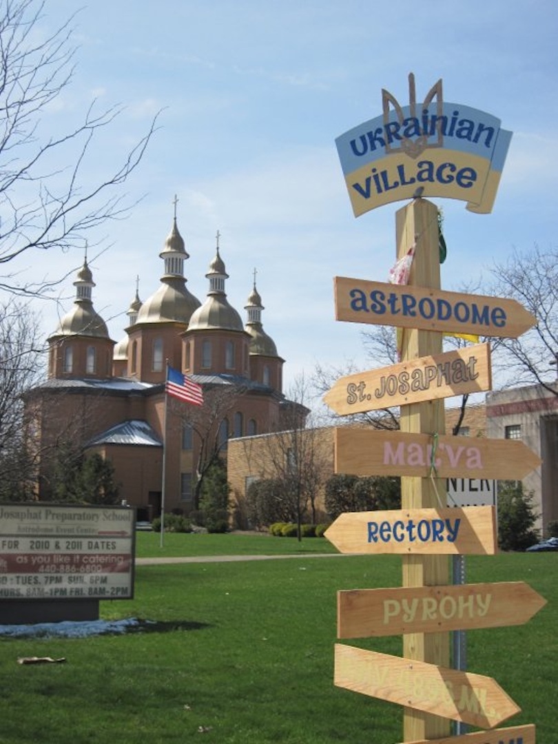
On an even more positive note, in 2008 the Parma City Council passed a resolution recognizing the many contributions that Ukrainians at Saint Josaphat and other institutions in the City had made, and honoring the Ukrainian community with the establishment of <a href="https://clevelandhistorical.org/items/show/863">Ukrainian Village</a>, a section of State Road beginning at Tuxedo Avenue on its north end and extending south all the way to Grantwood Drive, with signs alerting drivers of the existence of the Village. </p><p>Today, visitors to Parma, who drive to the suburb on State Road will, as they cross Brookpark Road, immediately take notice of the colorful signage which announces that they are entering Ukrainian Village. Within moments thereafter, they will see the five majestic onion domes of the beautiful Saint Josaphat Cathedral. The signs and the domes inform visitors not only of the historical importance of Saint Josaphat to Parma's Ukrainian community, but also of its importance to the City of Parma itself.</p><p><em><strong><a href="https://mail.clevelandhistorical.org/items/show/1078">For more (including 16 images) view the original article</a></strong></em></p>]]></summary>
    <published>2026-01-08T16:48:20+00:00</published>
    <updated>2026-04-17T19:17:43+00:00</updated>
    <link rel="alternate" type="text/html" href="https://mail.clevelandhistorical.org/items/show/1078"/>
    <id>https://mail.clevelandhistorical.org/items/show/1078</id>
    <author>
      <name>Jim Dubelko</name>
    </author>
  </entry>
  <entry>
    <title type="html"><![CDATA[The Sisters of Notre Dame : A Century of Devotion to Education in Cleveland ]]></title>
    <summary type="html"><![CDATA[<img src="https://mail.clevelandhistorical.org/files/fullsize/638eacb9b17ce16e346da058fa6da22b.jpg" alt="First Wing of Administration Building" /><br/><p>Notre Dame College, a cornerstone of higher education in South Euclid, Ohio, concluded its 102-year journey in 2024. Founded in 1922 by the Sisters of Notre Dame, the college was renowned for its strong academic programs, dedicated faculty, and vibrant campus life. The college's beautiful campus, designed by architect Thomas D. McLaughlin, is a testament to its rich history and commitment to providing a quality education. However, in more recent years, Notre Dame College faced numerous challenges that ultimately led to its closure. Declining enrollment, rising costs, and changing student expectations put significant strain on the institution's finances. Despite efforts to revitalize the college, these challenges proved insurmountable. The closure of Notre Dame College has had a profound impact on the South Euclid community. The college was a major employer, a cultural hub, and a source of pride for the community. Its loss is deeply felt by alumni, faculty, staff, and students.</p><p>The Sisters of Notre Dame trace their roots back to the Netherlands and Belgium, where the order was founded in 1816. In 1850, they became a separate order and began their mission in Germany. In 1874, the Sisters of Notre Dame arrived in Cleveland to teach at St. Peter’s Church. In 1877, they established Notre Dame Academy for girls, providing young women with quality education. The Sisters also served as the Notre Dame Motherhouse, a convent that housed a mother superior of their community, until 1888, further adding to the prestige and legitimacy of the sisters. The Sisters of Notre Dame and <a href="https://clevelandhistorical.org/items/show/304">St. Peter’s Church</a> share a deep-rooted connection to the Catholic faith and a common mission of serving the community. Both institutions have been integral parts of Cleveland’s Catholic community for over a century, contributing to the city’s rich history and cultural fabric. </p><p>One of their most notable contributions was the founding of Notre Dame College for Women in 1922. Initially located in the Notre Dame Academy that had moved to Ansel Road seven years earlier, the college quickly outgrew the space and moved to a forty-acre farm on Green Road in South Euclid, where it built the iconic Administration Building, a five-story structure that has stood as a prominent landmark in South Euclid since its completion in 1927. Its classrooms, spacious halls, and serene chapel provided an ideal learning environment for generations of women. The building's Gothic Revival architecture, with its arches and pointed windows, created an atmosphere of academic strictness and spiritual contemplation. </p><p>In addition to Notre Dame College, the Sisters went on to provide other educational opportunities, further expanding their commitment to Catholic education. They established Regina High School adjacent to the Notre Dame campus in 1953, Julie Billiart School in Lyndhurst in 1954, and Notre Dame Elementary School in Chardon in 1957. As the educational landscape shifted along with the movement of Catholics to the suburbs, the Sisters sold the old Notre Dame Academy building on Ansel in 1962, and it transitioned into a public junior high school. Notre Dame Academy (now Notre Dame-Cathedral Latin School) then relocated to Chardon.</p><p>Beyond their educational endeavors, the Sisters of Notre Dame have been dedicated to serving the needs of the community. They established Mt. St. Mary’s Institute to care for half-orphans and homeless children, operated a health center for the elderly and ill, and engaged in publishing, early childhood and adult education, and pastoral work. Through their dedication to education, community service, and religious life, the Sisters of Notre Dame have left a lasting legacy on the Cleveland area and beyond. </p><p>Meanwhile, Notre Dame College experienced significant growth and expansion. The South Euclid campus grew to include multiple buildings and sports fields, providing students with a modern and conducive learning environment. The college offered traditional on-campus learning, expanding to include Weekend College for teachers and non-traditional students in 1978 and eventually online courses. The college's commitment to student-centered learning was evident in its supportive academic centers, which provided resources and assistance to help students succeed. Beyond academics, Notre Dame College offered a vibrant campus life with a variety of arts and athletic programs, eventually competing in NCAA Division II. </p><p>However, the combination of declining enrollment and rising costs created a perfect storm for Notre Dame College. Despite efforts to cut costs and increase enrollment, the college was unable to overcome these challenges. Notre Dame, a cornerstone of higher education in South Euclid, Ohio, concluded its 102-year journey in 2024. While Notre Dame College may no longer exist, its legacy lives on. The college's alumni continue to make significant contributions to society, carrying forward the values and knowledge they gained during their time at the institution. The former campus, with its distinctive architecture, stands as a reminder of the college’s rich history and its impact on the community. The closure of Notre Dame College serves as a cautionary tale for other small liberal arts colleges. It highlights the challenges they face in an increasingly competitive higher education landscape. As we move forward, it is important to learn from the past and work to ensure the future of these institutions. All-in-all, it is evident that the sisters had such a rich history of education in the area with the college being the main example of their impact.</p><p><em><strong><a href="https://mail.clevelandhistorical.org/items/show/1043">For more (including 20 images) view the original article</a></strong></em></p>]]></summary>
    <published>2024-11-26T21:26:33+00:00</published>
    <updated>2026-04-17T19:17:43+00:00</updated>
    <link rel="alternate" type="text/html" href="https://mail.clevelandhistorical.org/items/show/1043"/>
    <id>https://mail.clevelandhistorical.org/items/show/1043</id>
    <author>
      <name>Michael Griffin </name>
    </author>
  </entry>
  <entry>
    <title type="html"><![CDATA[Shaker Historical Society and Museum: Challenging Suburban Resistance and Shaping Community Identity in the Quest for Home]]></title>
    <summary type="html"><![CDATA[<img src="https://mail.clevelandhistorical.org/files/fullsize/50726ca80912a440e06313046e9fd8e7.jpg" alt="Shaker Historical Society, 16740 South Park Boulevard (Scrapbook Excerpt)" /><br/><p>The Shaker Historical Society and Museum has a rich history marked by its successful establishment and resilience in overcoming challenges to secure a permanent location. The Museum presents historical artifacts and educational programs that extend beyond the <a href="https://clevelandhistorical.org/items/show/674">North Union Shaker</a> community, engaging Shaker Heights residents in public history. The legacy of the Van Sweringen brothers, who influenced the design of city streets and community values, is deeply embedded in the area’s physical layout and reflected in the Museum's role within the community.</p><p>Building on this foundation of historical interest, the story of the North Union Shaker community itself is central to understanding the origins of Shaker Heights. Founded by Ralph Russell in 1822, the Shaker community occupied the lands now known as Shaker Heights and Cleveland Heights. Although the community disbanded in 1889, its utopian ideals left a lasting legacy that helped shape the vision of the master-planned suburb. Interest in the Shakers within the community began to grow in the mid-1920s, when the Shaker Heights School District started incorporating local history into its educational programs. Teachers Edythe Turner and Pearl Lee Stark played a pivotal role in this effort, collecting Shaker artifacts and embedding them into the third-grade curriculum, ensuring that future generations would engage with this important chapter of the area’s past.</p><p>The Shaker community attracted interest from several institutions in the Cleveland area, with Wallace H. Cathcart, former director of the Western Reserve Historical Society (WRHS), initiating the Shaker collection in 1911. Today, the WRHS holds approximately 900 Shaker photographs from 1860 to 1920, which were vital in shaping a coherent public understanding of the North Union Shaker community’s legacy. Caroline B. Piercy, a Shaker Heights resident, extensively studied the Cathcart collection and published <em>The Valley of God’s Pleasure: A Saga of the North Union Shaker Community</em> in 1951. Her research led to connections with other local residents, including Rev. John M. Schott, Cary Alburn, Benjamin Jenks, and Councilman John A. Hecker, who took a major step in preserving this history by founding the Shaker Historical Society and Museum (SHS). Elizabeth B. Nord, the Museum's volunteer curator for twenty years until her death in 1972, was also instrumental in this effort. The Society began gathering Shaker artifacts and donations, hosting its first garden party on June 11, 1948, in the Shaker Room of the WRHS.</p><p>Over the next twenty-two years, the Shaker Historical Society relocated seven times before settling into a storefront at 3488 Lee Road in 1968. However, this location proved unsustainable due to high costs, prompting the board to seek a more permanent home for the Society and Museum. In 1966, a special board meeting was held in the basement of Boulevard School to discuss the donation of the Myers mansion. Designed by architect Daniel Reamer in 1910 for Louis Myers of the Van Sweringen Company, the mansion was being negotiated by his son, Frank Myers, as a potential permanent home for the SHS. The Myers mansion was historically significant, situated on the original site of the Shaker settlers’ farm and near Horseshoe Lake, created by the settlers’ dam. Despite this, local residents and neighbors at the time strongly opposed the Museum’s move into the area. Their concerns about relocating the Museum to a residential neighborhood reflected the nineteenth-century ideals behind the Van Sweringen brothers’ vision of an ideal “utopia.” In response, Mayor Paul K. Jones decided to allow neighborhood residents to voice their opinions based on issues of zoning policies.</p><p>The Van Sweringen brothers sought to control property values in Shaker Heights through deed restrictions, a common practice in American suburban development. By promoting homeownership, they aimed to stabilize property values and prevent “undesirable” neighbors, enforcing both aesthetic standards and racial covenants. In 1925, they introduced Restriction No. 5, which encouraged residents to return old property deeds for approval before selling. Zoning regulations were also implemented, designating certain areas for single-family homes while allowing commercial use in other zones. The northern areas of South Park Boulevard and Lee Road were reserved for single-family residences, while the neighborhoods south of South Woodland Road and Van Aken Boulevard were subject to a mix of zoning types. Together, Restriction No. 5 and the expanded zoning regulations reinforced the Van Sweringen brothers' vision of a white, upper-to-middle-class "utopia."</p><p>Although Shaker was well on its way to becoming a community that embraced social diversity, the Van Sweringen vision of exclusivity and zoning control was echoed decades later when the Shaker Historical Society's proposal to relocate to the South Park Boulevard neighborhood faced resistance. Much like the earlier concerns over "social invasion" and zoning laws, opponents feared the impact of the Society's move on the residential character of the area. <span>To bypass these objections, trustee Frank Myers donated the property to the state with vice president William R. Van Aken handling the legal complexities of the transfer, enabling the Society to contract with the State Department of Public Works and avoid city zoning regulations.</span></p><p>This effort to overcome zoning resistance marked a pivotal moment in the Shaker Historical Society's development and expansion. Drawing on this achievement, the Society began to shift its focus toward broader public engagement. The president of the SHS at the time, William Van Aken, discussed opening the Museum to all residents of northeastern Ohio, and the public was first invited into the space during a tour conducted around the Shaker Lakes in 1970. Building on this momentum, the Women's Committee of the SHS was established in June 1971 to increase interest, funding, and volunteer support for the museum. In 1972, Elizabeth Nord made a significant contribution by donating her personal library to the SHS and receiving the Golden Deeds Award from the Exchange Club of the Heights. Tragically, she passed away from a heart attack just four months later. The 1980s marked a period of expansion for the Society, which showcased four major exhibits and elected its first female president in 1988, further solidifying its commitment to inclusive public history.</p><p>The success of these early efforts laid the groundwork for the Shaker Historical Society’s continued growth and evolution. As the Society expanded its reach and strengthened its community ties, it also began to reflect the values and identity of Shaker Heights itself. The suburb, deeply intertwined with the concept of "home," influenced the Society’s transition into a single-family residence, further aligning its mission with the broader emphasis on home and place that defines the area. By broadening its focus from solely representing the Shakers to engaging more deeply with the diverse local community, the Shaker Historical Society and Museum is forging a new identity for public history in Shaker Heights—one that reflects the suburb's contemporary values while enriching its historical narrative.</p><p>Today, the Shaker Historical Society and Museum, along with the Elizabeth B. Nord Memorial Library and Archives, operates in its permanent location at 16740 South Park Boulevard. Despite past resistance, the museum now stands as a hub for public history, education, and community development, honoring the legacy of the North Union Shakers on the very land they once inhabited.</p><p><em><strong><a href="https://mail.clevelandhistorical.org/items/show/1040">For more (including 14 images) view the original article</a></strong></em></p>]]></summary>
    <published>2024-11-26T01:14:49+00:00</published>
    <updated>2026-04-17T19:17:43+00:00</updated>
    <link rel="alternate" type="text/html" href="https://mail.clevelandhistorical.org/items/show/1040"/>
    <id>https://mail.clevelandhistorical.org/items/show/1040</id>
    <author>
      <name>Makialani Kanewa-Mariano</name>
    </author>
  </entry>
  <entry>
    <title type="html"><![CDATA[Shore Cultural Centre: A Public School Reimagined as a Community Hub]]></title>
    <summary type="html"><![CDATA[<img src="https://mail.clevelandhistorical.org/files/fullsize/1a498c202ac3d28128ee6936109041cf.jpg" alt="Shore High School" /><br/><p>For nearly seven decades, the building that is now Shore Cultural Centre served as a public school. The Euclid Village School District built Shore High School in 1912-13 after it purchased land between Babbitt Road and East 222nd Street near where these roads converged at Lakeshore Boulevard in the heart of the suburban village. The three-story school was constructed at a cost of $42,500 and was paired with another new high school built near Euclid and Chardon Road, Central High School. Although Euclid remained a small village at that time, it stood on the cusp of significant growth as growing numbers of people moved to Cleveland’s first-ring suburbs. In its early years, Shore High School, like Central High, housed all grades. Only the top floor of Shore High School actually housed high school classrooms. Neither of the village’s high school buildings initially had an auditorium, necessitating the use of Euclid City Hall for graduation ceremonies. </p><p>By 1928, according to the Directory of Euclid, Euclid-Central and Euclid-Shore High Schools collectively served 615 pupils, a reflection of Euclid’s growth from about 2,000 to 12,000 people in the time since the schools opened. The directory also noted the strength of Shore High’s Musical Department, which staged many different productions, including “The Spring Maid” and “The Mikado.” The directory also claimed that Euclid had one of the largest village school systems in Ohio, a distinction that reflected the fact that Euclid was still two years away from being incorporated as a city. Shore High School’s continued growth led to the addition of eight new attachments to the original building over the next couple of decades. The school had known nothing but growth, so Euclid residents could only imagine more of the same. </p><p>Shore High School’s future became uncertain after World War II. With the suburb’s explosive growth, a new Euclid High School building opened for grades ten to twelve in 1949. As a result, both Shore and Central High Schools were converted into junior high school that housed grades seven to nine. The original Central High School building was demolished in 1968 following the construction of a newer building, while the original Shore High building continued to serve the district until Euclid began to experience population loss in the 1970s. With demand for classroom space receding, Shore Junior High School closed in 1982, leaving the 1913 building’s fate in question. </p><p>Thanks to the school building’s central location in the community, the city saw many offers over time by people who wanted to redevelop the land. However, the people of Euclid decided instead to recast the building as a community center. Shore Cultural Centre opened in 1985 and, following the school board’s sale of the building to the City of Euclid in 1989, it underwent a major renovation. Shore Cultural Centre reflected efforts by community leaders who had lived in Euclid for decades. One of them, Dolly Luskin, headed the effort to establish this center. Luskin had served on the school board for years in various leadership positions. She believed in the building’s potential as a place for teaching future generations about arts and culture while honoring a physical landmark from the city’s early years. Shore Cultural Centre preserves the memory of Shore High School as it provides cultural activities in the city. Its auditorium is the home of the Euclid Symphony Orchestra and serves other performing arts organizations, as well as some nonprofits and businesses. </p><p>Despite Shore Cultural Centre’s updated role in the community, it became the subject of debates about its utility. As early as 2007, some in the community argued that the building should be converted into some other use or sold to the highest bidder due to its land value. Ideas for what should be done with the building came from all angles, as seen in contentious local city council meetings. The problem, some argued, was that Euclid was pouring money into a facility that was losing more money than it made through renting its spaces. The city, which suffered a significant loss of its tax base after losing one-third of its population in the four decades after 1970, struggled in recent years to make needed repairs and improvements to the aging building. As a result, the city continued to troubleshoot the facility’s problems. By 2023, it had made some progress. Shore Cultural Centre received an earmark of federal funds to upgrade some of its infrastructure and was reportedly 93 percent occupied. </p><p>Shore Cultural Centre embodies the story of Euclid and, more broadly, of older suburbs. As a school, it rose from humble beginnings, grew with all the vigor of the suburb whose students it served. Then, as in many inner-ring suburbs, Euclid endured the deindustrialization and population flight to more outlying areas or even other states, leaving school facilities in excess of the need. The school’s reinvention was part of a wider effort to reinvest in the community, but like the city, Shore Cultural Centre continues to navigate toward the promise of a sustainable future for a historic asset.</p><p><em><strong><a href="https://mail.clevelandhistorical.org/items/show/929">For more (including 9 images) view the original article</a></strong></em></p>]]></summary>
    <published>2020-12-13T22:25:05+00:00</published>
    <updated>2026-04-17T19:17:42+00:00</updated>
    <link rel="alternate" type="text/html" href="https://mail.clevelandhistorical.org/items/show/929"/>
    <id>https://mail.clevelandhistorical.org/items/show/929</id>
    <author>
      <name>Harrison McCreight</name>
    </author>
  </entry>
  <entry>
    <title type="html"><![CDATA[Parmatown: A Civic Center for Postwar Parma]]></title>
    <summary type="html"><![CDATA[<img src="https://mail.clevelandhistorical.org/files/fullsize/2404ab218c9497624e85072d7a578fef.jpg" alt="Santa Claus Castle at Parmatown Shopping Center" /><br/><p>Parmatown was part of a national trend that emerged in the 1950s sparked by the father of shopping malls, Victor Gruen. Originally, like many malls of that time, Parmatown once looked more like it looks today as the new Shoppes at Parma before it became enclosed in 1965. In fact, there is actually a statue that has managed to remain outside of the Shoppes of Parma to this very day that dates to Parmatown's opening, which is the statue of a seal. While there are still remnants of the old Parmatown such as the seal statue, a lot has changed throughout the years, specifically its iconicism as a place where everyone used to want to be and the pinnacle of a town's consumerism. </p><p>Parmatown featured a wide array of stores to shop from throughout its years, including department stores such as May Co. and Higbee's, many shops for dress clothes or casual clothes depending on the time period, restaurants, one of which, Antonio's Pizza, can be seen to this very day, and entertainment ranging from Aladdin's Arcade to a movie theatre. This enclosed community allowed people of all ages and primarily those of younger age to experience a sense of wonder and excitement that they couldn't have found anywhere else, a home away from home. For many of us, shopping malls are places with a wealth of childhood memories, and one of the first places that one gets to experience independence away from one's parents. The welcoming warmth of the shopping mall helped to shape the image of what it meant to be American during a time when consumer culture portrayed somewhat of an idealized romance regarding shopping malls and the indulgences they offered.</p><p>Closely mirroring the broader history of malls, Parmatown was, like most malls, an experience, one that was a cornerstone of Parma culture for generations. Longtime Parma resident Jane Kovach recalls, "It used to be a big deal to go to the mall. One wouldn't just wear jeans and shirt; people wanted to show respect to each other by dressing decently–no jeans and a t-shirt." Despite the informality many younger people may associate with suburban malls, Kovach's memory is a reminder that in their early days, malls shared a lot with downtown shopping, where people also tended to dress up in their finer clothes.</p><p>Officially opening in 1956, Parmatown was not originally like the mall that stood for generations. Instead it was an open-air shopping plaza like the kind we have today in Parmatown's old location of what is now the Shoppes at Parma. It was not until 1965 that the mall was enclosed, taking the form that most people would associate with a mall. Parmatown would have many attractions throughout its years as a mall, both inside and out, including the annual Rib N Rock, an arcade, Easter events with live animals, and more. Parmatown's influence extended far and wide, not least through its promotion in advertisements throughout Cleveland newspapers. </p><p>During Parmatown's time before becoming the Shoppes at Parma, it underwent three expansions: first in 1965 as an enclosed mall, second in 1966 adding a Higbee's with a second floor and a fully enclosed west wing, and third in 1979 to add a new south wing, a food court, and a second floor for J.C.Penney. All of the expansions highlight the growing popularity of the mall phenomenon. Despite its success as an enclosed mall for almost fifty years, however, on January 4, 2012, the first sign of Parmatown's downfall appeared with the closing of Macy's. Shocking everyone, Macy's would lay off its 127 employees that spring. Due to underperformance of the store, Macy's decided it was best to focus on the higher performing stores rather than keep underperforming ones like that of Parmatown barely afloat. The lost jobs were those which were not unionized, but more importantly they were all jobs that once thrived for decades, highlighting the warning signs of a changing economy. At this point, Parmatown representatives announced plans to keep the mall open and try out new stores, which indicates that amid the economic hardship, mall representatives were likely told to keep quiet regarding the mall's failing state in order to see just how much longer the mall could keep generating revenue before its closing would be declared.</p><p>Finally, it was announced in 2013 that Parmatown mall would be closing and the owner would be given a 30-year tax break in order to help finance a renovation where the mall would be taken back to a state closely resembling its original form until it was enclosed in 1965. The agreement was that Phillips Edison & Co. would use one-hundred percent of new property taxes generated at the mall on infrastructure improvements and demolitions. By 2015, the Shoppes at Parma were almost fully built, and as of 2019 the center appeared to be thriving from an outsider's perspective, with businesses all around where the entrance to Parmatown once was, now providing an open-air concept just like Parmatown before it was enclosed mall in 1965. It appears as if the mall got its third chance at life.</p><p>Although Parmatown surely experienced a surge of new competition when SouthPark Mall opened in Strongsville in 1996, Parmatownâ€™s demise primarily stems from the rise of the internet, with people being able to access billions of products that may fit a particular need better than what a store can fulfill at any given moment, all at a cheaper price. The impact of massive companies like Amazon or Walmart taking over the retailing industry was ultimately too much for Parmatown. Historian Vicki Howard, author of <em>From Main Street to Mall</em>, argues that "traditional department stores no longer had a powerful trade voice as they had earlier in the twentieth century, when presidents sent messages to their annual conventions or appointed merchants to head important wartime agencies or consult on national policy." Eventually, certain companies started to reign supreme in the fight for market share, and have since made it harder for traditional department stores to remain in business. A perfect example of this phenomenon occurring at Parmatown, along with many other malls, was when when Walmart took over the old the Dillard's in 2004 and remains in the same building until this very day. </p><p>Parmatown was a victim of a changing economy, one in which online competition outshines brick-and-mortar retailers of all sizes, and only the strongest survive. Pairing the changing economy with little innovation in terms of trends, Parmatown was eventually forced to close and move to an open-air model reminiscent of it had been prior to 1965. While the Shoppes at Parma is not technically considered a mall, it still has mall-like inflections with tens of stores along a massive strip. The mall-like inflections, however, are limited. They foster little sense of community, as the plaza model no longer forces people to shop in one massive building, instead granting them the ability to move only between their car and a particular store. Despite the tradeoffs, hopefully the plaza model will sustain the revival of the Shoppes for many years to come.</p><p><em><strong><a href="https://mail.clevelandhistorical.org/items/show/892">For more (including 10 images) view the original article</a></strong></em></p>]]></summary>
    <published>2019-12-02T07:30:20+00:00</published>
    <updated>2026-04-17T19:17:42+00:00</updated>
    <link rel="alternate" type="text/html" href="https://mail.clevelandhistorical.org/items/show/892"/>
    <id>https://mail.clevelandhistorical.org/items/show/892</id>
    <author>
      <name>Ian E. Phillips</name>
    </author>
  </entry>
  <entry>
    <title type="html"><![CDATA[Richfield Coliseum: Mileti&#039;s Folly]]></title>
    <summary type="html"><![CDATA[<img src="https://mail.clevelandhistorical.org/files/fullsize/bf6d8b04cf8fea9d8c3a0ab98874a78e.jpg" alt="Richfield Coliseum, I-271, and the Ohio Turnpike" /><br/><p>National Basketball Association Hall of Fame inductee Larry Bird’s favorite place to play was one steeped in history, with hundreds of sporting events and concerts taking place within its confines each year. When Bird discusses his favorite place to play he is not talking about the Celtics’ Boston Garden where he won three NBA championships, but is instead referring to the Richfield Coliseum. Larry Bird praised the venue often both during and after his playing career, frequently expressing his affinity for the arena, saying if one were to create the perfect arena it would be in the Coliseum’s image. His compliments did not come without some critiques, all that reference the location of the arena. He disliked the long drive out to the Coliseum twenty-five miles south of Cleveland, which required his team to leave early in order to arrive on time, and wished it was “in a city somewhere — not a suburb.”</p><p>The construction of the Richfield Coliseum was a hot topic in Northeast Ohio in the early 1970s, mainly due to its location in Richfield Township, which is over twenty-five miles south of downtown Cleveland. This would be a significant location change from the Arena that had not only been home to the Cavaliers but also the Cleveland Barons since its opening in 1937. The site was chosen by Cleveland Cavaliers and Indians owner Nick Mileti, who saw its northern Summit County location as optimal for bringing in the largest possible number of Northeast Ohioans to events because, as he noted, no one lived in Lake Erie. Mileti wanted the Richfield Coliseum to be “the big brother to Madison Square Garden,” not only a testament to his perceived quality of the new location, but its upcoming cultural significance. </p><p>This move of the Cavaliers and other sports teams was met with resistance almost immediately after Mileti announced his plans to construct the Richfield Coliseum. Opposition to Mileti’s plans were from the politicians and officials of Cleveland, who all wanted the Cavaliers to remain downtown and keep other performing acts coming to the city, not to a venue twenty-five miles away. This desire was motivated by the revenue produced by the events held downtown and was aligned with their attempts to revitalize the area. Ultimately city officials were unable to prevent Mileti from relocating his teams to Richfield, and the twenty-thousand–seat venue was constructed in Summit County.</p><p>The Richfield Coliseum hosted the Cleveland Cavaliers and Cleveland Barons as well as countless concerts during its twenty years of operation. The Coliseum proved it was a viable event location from its opening, hosting Frank Sinatra on October 26, 1974, the first of many famous artists to visit Richfield Township. The list of acts that performed in Richfield is strikingly similar to the current list of inductees of Cleveland’s Rock and Rock Hall of Fame, with acts like Stevie Wonder, Eric Clapton, KISS, The Who and Grateful Dead performing in the Coliseum. </p><p>Concerts were not the only significant events that took place at the Coliseum, it also had its fair share of historic sports moments. Richfield Coliseum hosted the Chicago Bulls for Game 5 of the 1989 Eastern Conference First Round where Michael Jordan would hit ‘The Shot’ as time expired to end the series with a 101-100 Bulls win. Another significant event that took place in the Coliseum was a heavyweight boxing match between Muhammed Ali and Chuck Wepner. The bout was held on March 25, 1975, and determined the World Boxing Association and World Boxing Council heavyweight title. Wepner, the underdog, lasted until nineteen seconds before the final bell when he lost by TKO. Wepner’s life and match against Ali has been widely credited as the inspiration for the <em>Rocky</em> film franchise, which depicted an underdog Rocky Balboa going toe-to-toe with the champion Apollo Creed. </p><p>The Cavaliers returned to downtown Cleveland in 1994 after twenty seasons in Richfield, and the Coliseum was torn down five years later in 1999. The Coliseum was an important building both locally and nationally from when it was first proposed by Nick Mileti, and embodied the national trend of sports teams fleeing city centers in the 1970s. The demolition of the Coliseum was less controversial than its construction, yet many came to the site in Richfield to see it one last time. Twenty years of historic events occurred within its concrete walls, events that would not only hold significance for Northeast Ohio but the nation as a whole. Perhaps Nick Mileti’s 1974 prediction of a venue on par with Madison Square Garden wasn’t too far from the truth.</p><p><em><strong><a href="https://mail.clevelandhistorical.org/items/show/886">For more (including 9 images) view the original article</a></strong></em></p>]]></summary>
    <published>2019-11-20T20:25:09+00:00</published>
    <updated>2026-04-17T19:17:42+00:00</updated>
    <link rel="alternate" type="text/html" href="https://mail.clevelandhistorical.org/items/show/886"/>
    <id>https://mail.clevelandhistorical.org/items/show/886</id>
    <author>
      <name>Isaac Atencio</name>
    </author>
  </entry>
  <entry>
    <title type="html"><![CDATA[Spice Acres <br />
: Sustainable Farming in Cuyahoga Valley National Park]]></title>
    <summary type="html"><![CDATA[<img src="https://mail.clevelandhistorical.org/files/fullsize/82dc398cc2c7e9192d7b556c50c7f8a0.jpg" alt="Spice Acre SIgn" /><br/><p>On any given night people flock to Spice Kitchen on Detroit Avenue in Cleveland’s Detroit Shoreway neighborhood for great food, but diners might not realize where that food comes from prior to arriving at their table. Ben Bebenroth of Spice Kitchen has a 13-acre farm aptly named Spice Acres located in Cuyahoga Valley National Park which supplies some of the food that he cooks. The produce he grows also inspires the dishes he cooks, which vary based on what’s in season. The food he cooks in early summer will be vastly different than what appears on his menu in the early fall. What he doesn’t get from his farm he buys from local farmers in a 150-mile radius from his restaurant. Bebenroth is committed to the farm-to-table ideal as a means to provide the best cuisine to offer his guests. Even the floral decorations that grace the tables come from his farm. </p><p>Spice Acres is one of eleven farms that are part of the Countryside Initiative, which promotes sustainable farming practices within Cuyahoga Valley National Park. Those lucky few, like Bebenroth, who get a long-term lease, are then able to continue the tradition of sustainable farming practices. The process of acquiring a lease is a time-consuming process, in order to ensure that the lessee’s vision and business plan are in line with the Initiative’s stated mission. The Countryside Initiative was started in 1999 as a way to incorporate working farms into the National Park landscape. Farming was a part of the Cuyahoga Valley for generations prior to the suburbanization that started to consume farmland starting in the early 20th century. One farm that has been able to hang on is Szalay's Farm, which has been around for about 80 years. With the creation of the Countryside Initiative the plan was to implant farming ventures back into the Cuyahoga Valley as a means of education as well as allowing farmers to come in and farm the land. As part of the lease process, a farmer who is bidding on one of the current farms submits a business plan which outlines how they will use the land once they sign the lease. The application process takes several months to complete so as to ensure the right fit for the prospective farmer and farm. This process also helps to sort out those who are able to really farm for a long period of time. Once the application process is complete, the Initiative and the farmer enter into a 60-year lease agreement. </p><p>Bebenroth’s vision is to promote the farm-to-table ideal in which people are able to get food within a 150-mile radius of their home, which aligns with the Initiatives mission of preservation. What started as a small garden in his back yard led to signing a multi-year lease with the Countryside Initiative so as to expand his growing capacity for Spice Kitchen. At Spice Acres he brings that vision to life as he adds a variety of produce and livestock to his property to support the variety of menu items on offer at his restaurant. Thus far he has added pigs to his farming venture and hopes to continue to add other livestock to his ever-expanding farm bounty. Farming for Bebenoth has also become a way of creating an environment of social change on a local level. He has found that educating children is often easier than reeducating adults in healthy eating habits. Although he offers a variety of education programs that focus on being health-conscious in what they eat, Bebenroth also encourages people to be good stewards of the land. </p><p>In recent years Spice Acres has offered themed outdoor dinners, called Plated Landscapes Dinners, which feature in-season produce. As part of the dinner Bebenroth offers tours of his farm prior to the beginning of dinner, and he also engages with his guests during dinner. His hope is to show people the benefits of eating food that is grown closer to their home. Offering these outdoor dinners allows people to get a better feel of how the farm-to-table movement works and could have a positive impact on their daily lives. Interacting with people on his farm while having a meal together also allows for dialogue between those who grow the food and those who partake in the themed dinners. Interacting with his guests is an important aspect of his work, at both Spice Acres and Spice Kitchen, to inspire people to eat more local food. During the summer months he also allows families to visit his farm and encourages them to procure items from special meals from his farm. One example of people getting food items from his farm is obtaining flowers for their Easter table or a ham for Thanksgiving. </p><p>The Countryside Initiative has impacted how the Cuyahoga Valley National Park educates visitors on farming practices not only within the boundaries of the park but within the greater Cleveland-Akron area. Over the years the Initiative has increased its presence not only by leasing farms but also by setting up farmers' markets so people have a means of buying locally grown food, such as the farmers' market at Howe’s meadow during the summer months. The hope is to ensure that people can become more aware of how their food is grown and encourage engagement between the grower and the buyer. Allowing farmers to lease land from the Cuyahoga Valley National Park has meant that a way of life may be preserved for future generations to experience a way of life that is slowly fading from the American landscape.</p><p><em><strong><a href="https://mail.clevelandhistorical.org/items/show/879">For more (including 10 images) view the original article</a></strong></em></p>]]></summary>
    <published>2019-11-20T20:07:44+00:00</published>
    <updated>2026-04-17T19:17:39+00:00</updated>
    <link rel="alternate" type="text/html" href="https://mail.clevelandhistorical.org/items/show/879"/>
    <id>https://mail.clevelandhistorical.org/items/show/879</id>
    <author>
      <name>Jenny Payne</name>
    </author>
  </entry>
  <entry>
    <title type="html"><![CDATA[Ukrainian Village: Suburban Heir of a Tremont Legacy]]></title>
    <summary type="html"><![CDATA[<img src="https://mail.clevelandhistorical.org/files/fullsize/1e3d7fa8fe82aa3e7087cadc08140c50.jpg" alt="Ukrainian Village Sign" /><br/><p>When you leave Cleveland for the suburbs, perhaps the last thing you expect to find is a slice of another country nestled along the streets. In 2009, the suburban municipality of Parma to the southwest of Cleveland officially recognized its long-standing settlement of Ukrainians, giving them a "village" of their own. Ukrainian Village, located along a two-mile stretch of State Road, had been the vision of Ukrainian Americans since the 1940s. The rise of suburbs began to push them out of their original enclave in Cleveland’s Tremont neighborhood, setting the stage for the emergence of the vibrant community that is present today.  </p><p>In the late nineteenth century, immigrants of all walks of life arrived in Cleveland because of many different factors. Ukrainians were escaping political and economic hardships by coming to the United States, looking for work in any shape they could find. Ordinarily, they took up various jobs in Cleveland’s thriving industrial plants and mills. These jobs helped them to save money to send back to their relatives in the “old country.” They ended up establishing cultural and religious centers that have changed over time yet still stand as strong symbols of Ukrainian pride.   </p><p>Ukrainian settlement in Cleveland began in Tremont. The community began to put down roots in order to keep their memories and customs from home alive. The first of these Ukrainian institutions was the Saints Peter and Paul Ukrainian Church, built in 1910 on West 7th Street. Shortly after, St. Vladimir Church was also established in Tremont. The first few years of worship took place at Craftman’s Hall on West 14th Street.  In 1933 the congregation's original church building was dedicated. It still stands on West 11th Street but it is now the Spanish Assembly of God Church. In 1967, the St. Vladimir Ukrainian Orthodox Cathedral in Parma was opened for worship. Its shift from Tremont to Parma reflected the trend of people moving to the suburbs after an influx of immigration, pushed by the Holodomor (famine) of the 1930s, German occupation of the Ukraine during World War II, and displacement under Stalinist rule in the Cold War era. </p><p>Churches like St. Vladimir’s were the anchor of the Ukrainian community. Not only did they provide a sense of community in a new and strange country, they also kept the cultural of the old country alive. One of the many new organizations was the Ridna Shkola, a school teaching heritage, language, and customs to the youth of the community. Today, classes are held at St. Josaphat Cathedral on State Road.  </p><p>Churches are not the only anchors of Ukrainian culture in the Ukrainian Village today. Many shops, such as Lviv International Foods and State Meats, offer a taste of the ethnic fare unique to many people. These places, among others, serve as the backbone of the Ukrainian community. In 2007, the board of trustees from St. Vladimir’s Church asked the city of Parma to hang decorative banners and to dub State Road Ukrainian Village. First, however, much work had to be done, including landscaping, restoring storefronts, and placing banners and murals to signify the village’s presence. The vision came to life only a year and five months after work began. Ukrainian Village was officially dedicated on September 19, 2009, and was celebrated with a festival, religious services, and a parade.  </p><p>The lasting legacy of the Ukrainian immigrants can be viewed not only through Ukrainian Village, but also in Tremont where some of the original settlements still stand. These institutions, regardless of their locations, stand for the progress of a people and the achievements they have made.  </p><p><em><strong><a href="https://mail.clevelandhistorical.org/items/show/863">For more (including 12 images) view the original article</a></strong></em></p>]]></summary>
    <published>2019-01-23T01:06:06+00:00</published>
    <updated>2026-04-17T19:17:42+00:00</updated>
    <link rel="alternate" type="text/html" href="https://mail.clevelandhistorical.org/items/show/863"/>
    <id>https://mail.clevelandhistorical.org/items/show/863</id>
    <author>
      <name>Olivia Garl</name>
    </author>
  </entry>
  <entry>
    <title type="html"><![CDATA[Frostville: Resurrecting the Ghosts of a Rural Past in Suburban North Olmsted]]></title>
    <summary type="html"><![CDATA[<img src="https://mail.clevelandhistorical.org/files/fullsize/d6fdd3017157418674b5c5248ee4da98.jpg" alt="Rocky River Valley" /><br/><p>Awakened from the grave on a chilly October evening in 1975, the ghostly manifestation of Western Reserve pioneer Thomas Briggs greeted trespassers at the Frostville Museum complex in Cleveland Metroparks Rocky River Reservation with scowls and threats of retribution over the displacement of his beloved home. Brave tour leaders steered visitors towards the not-quite-living history exhibition of Briggs’s partially renovated residence, regaling them with details from letters penned by the phantom docent. The writings, compiled by the Olmsted Historical Society, recounted the labors involved in constructing the home and the settler’s joy upon its completion. The specter could have shown a bit more gratitude; the house was previously slated for demolition but had been rescued by the historical society. With funds scraped together by hosting events such as annual antique auctions, members had managed to relocate a 20 x 40 foot section of the 139-year-old home from Lorain Road in North Olmsted to museum grounds in 1969. Efforts to restore the Greek Revival style building in accordance with its original design were well underway. The sturdy home’s new neighbors included a farmhouse erected in 1877,  a small storage shed containing a horse-drawn hearse, and a recently constructed barn that displayed farm tools and a vintage fire engine.   The tiny pioneer village of Frostville was slowly being assembled within the rural terrain of the Cleveland Metroparks system. </p><p>Since the allocation of Frostville's grounds for use as a public museum in 1962 by Cleveland Metroparks, a handful of Olmsted Historical Society members stationed out of a farmhouse worked tirelessly to resurrect ghosts of the region’s earliest European and American settlers.  The group was founded in 1953 as the North Olmsted Historical Society. Its members were not alone in their efforts to unearth a world whose demise was symbolized by highways and generic housing stock. In North Olmsted, and across the United States, the changes wrought by suburbanization spurred the establishment of organizations dedicated to preserving relics of local history.  By the end of the postwar suburban boom, Cuyahoga County had no less than 28 historical societies devoted to conjuring up the restless souls of a distant—and often imagined—past.</p><p>This post–World War II era marked the beginning of rapid change in North Olmsted and its surroundings, and it offers the backdrop for the historical society's invocation of the Briggs ghost. Across the United States, urban sprawl and suburbanization transformed the character and landscape of small communities situated outside urban centers.  Consumer spending that had been restrained during the Great Depression and World War II was unleashed. Demand for homes and consumer goods skyrocketed. </p><p>A slight complication quickly came to light. The construction of new housing had been at a relative standstill in an economy marked by rationing. The public not only had freshly available reserves of money, but Depression-era federal policies offered Americans greater access to affordable, long-term loans. The passage of the G.I. Bill further encouraged home ownership among veterans through a guarantee of low interest mortgages that did not require a down payment. In 1946, the United States Senate estimated that over three million homes were immediately needed to meet consumer demand. America was amidst a housing crisis.</p><p>As postwar manufacturing switched back to the production of consumer goods, a burgeoning automobile industry stimulated home building in places such as North Olmsted. The annual production of cars in America grew from 70,000 in 1945 to over two million the following year. This output rose to over 3.5 million by 1947. To accommodate the new surplus of cars clogging the roadways, vast sums of federal and state funding were allotted to the construction of highway infrastructure during the 1950s. The outmigration of Cleveland residents to the suburb of North Olmsted centered along Lorain Road, which provided a fairly direct route between the cities. The opening of the Ohio Turnpike to traffic in 1955 further accelerated the growth of residential and commercial development in the region.  </p><p>With demand for housing compounded by new transportation networks into and out of cities, construction in suburbs flourished. The grounds that once sustained North Olmsted’s farming community were quickly subdivided and dissected with roads. Barns disappeared from the horizon. In their place, neighborhoods were platted and quickly erected using contemporary construction methods. Feeding the building frenzy, North Olmsted—declared a city in October 1951—witnessed an influx of new residents. A 1950 population of approximately 6,600 residents, which had nearly doubled during the prior decade, increased to over 16,000 by 1960. The trend continued, and the population reached almost 35,000 ten years later.  Both commercial activity and the infrastructure of the city grew in turn.  Notably, the late 1950s saw the beginnings of what would become the Great Northern Mall. The shopping complex helped transform North Olmsted into a regional retail center.  </p><p>Suburban growth also left a wake of destruction in its path. Long-standing structures were regularly razed to make way for residential, commercial and retail developments. Open lands previously used for farming, greenhouses, and hunting disappeared. New settlers couldn’t entirely be blamed for vestiges of the past vanishing from the landscape. Time had taken its toll on many of the region’s oldest buildings, necessitating either demolition or the pouring in of funds for rehabilitation. Countless structures had grown decrepit through years of owner neglect or abandonment. The oldest buildings that remained in the increasingly suburban landscape, however, took on new meaning. They came to symbolize the community’s rural past. In North Olmsted, the death knell for idyllic rural society was countered by the historical society's efforts to salvage physical representations of the past.</p><p>The village of Frostville was a response to the changes brought on by suburbanization;  the historic enclave was born from an endeavor by the North Olmsted Historical Society to prevent the demolition of a vacant home standing within the Rocky River Reservation. The aged farmhouse sat on land purchased by the Metropolitan Park Board in 1925.  The homestead was maintained as a rental property until the 1950s, despite not having electricity or indoor plumbing. The historical society rallied upon learning of the building’s imminent doom, and incorporated as a non-profit association in 1961. The Cleveland Metropolitan Park Board agreed to spare the structure for use as a public museum and cultural center, even though policies enacted during the 1950s curtailed the allocation of park lands for exclusive use by private groups.  </p><p>The relationship between the two organizations was forged on common ground. The Park Board was also reeling from the unsettling impact of suburbanization, and searching for ways to promote preservation and conservation of its lands. By the mid 1950s, parking lots in the Metropolitan Park system overflowed with cars during the summer months. Lines formed at picnic areas for use of grills and public amenities, and the many pairs of feet trampling through green lawns were decimating the flora and eroding the soil. The ever-present threat of environmental degradation escalated as increased populations settled adjacent to park land, especially in connection with the pollution of rivers, creaks and streams. By the late 1950s, park director Harold W. Groth expressed concern that there were “too many people for too little land.” Nature wasn’t being given a chance to recover from the seasonal onslaught of humans. For the first time in its history, the Park Board found it necessary to deviate from the original Metropolitan Park system plan. A proposal was published in 1961 recommending an 8,400 acre park expansion project. Land for the Bradley Woods Reservation in North Olmsted and Westlake was acquired by 1962 to help alleviate overcrowding at Rocky River Reservation and Hinckley Reservation.  </p><p>Just as the Park Board tirelessly worked to recreate an idealized representation of the region’s lost natural environs through landscaping, the North Olmsted Historical Society labored to materialize an interpretive memory of the suburb’s frontier past. As an affiliate of the Park Board, the historical society took on the financial responsibilities of running and maintaining the on-site museum. The farmhouse—known as the Prechtel House—was remodeled, painted, vanquished of bees, and connected to the electrical grid. Descendants of Olmsted Township's earliest settlers donated antiques to furnish its interior. The homestead was named Frostville to commemorate the area’s first post office, which opened in 1829 at the home of Dr. Elias Carrington Frost. The museum was officially opened to the public as part of North Olmsted's sesquicentennial anniversary celebration in 1965. During these early years, the scope of the society’s mission broadened to encompass the historic preservation of the entire original township. The organization’s name was trimmed to Olmsted Historical Society in 1968.</p><p>Guided by Olmsted Historical Society's vision for recreating a small village representative of 19th-century life in Ohio, Frostville steadily grew and took shape as a living history museum.  In 1976, a one-room cabin built during the mid 1830 was placed in the company of the Prechtel House and Briggs House.  A two-story federal style home known as the Carpenter House, which was also erected during the 1830s, was transported to Frostville in 1987. A church dating back to the mid-1800s was relocated to the homestead in 2005, and was soon joined by a carriage house traced to North Olmsted’s first settler. The restoration process for each historic building was long and costly, with many a rummage sale, haunted house, and auction held to acquire necessary finances. Additional structures built on-site included a general store, an events barn, a workshop, and a display barn. All the while, the historical society continued to curate a collection of antiques representative of the region’s history. In 2017 the Olmsted Historical Society constructed a one-room schoolhouse and hoped to rebuild a detached summer kitchen annex of the Carpenter House. </p><p>After over half a century in operation, Frostville is no longer haunted by the ghost of Thomas Briggs during the Halloween season. The turmoil created by the rapid suburbanization of North Olmsted in the 1950s and 1960s subsided. The rush of newcomers slowed to a crawl; the population peaked in the 1980s at over 36,000 residents, and proceeded to decline. While traces of the region’s agricultural past have all but disappeared from the city's landscape, members of the historical society continue their efforts to keep the past alive at the museum complex. Visitors to the living museum in Rocky River Reservation are invited to surround themselves in a world pieced together through the research. physical toil, and craftsmanship of Olmsted Historical Society members. By curating an environment illustrative of 19th century Americana, the village of Frostville offers park-goers a physical link and sense of continuity with the bygone days of Olmsted Township's earliest settlers. </p><p><em><strong><a href="https://mail.clevelandhistorical.org/items/show/724">For more (including 12 images) view the original article</a></strong></em></p>]]></summary>
    <published>2015-07-27T02:39:51+00:00</published>
    <updated>2026-04-17T19:17:41+00:00</updated>
    <link rel="alternate" type="text/html" href="https://mail.clevelandhistorical.org/items/show/724"/>
    <id>https://mail.clevelandhistorical.org/items/show/724</id>
    <author>
      <name>Richard Raponi</name>
    </author>
  </entry>
  <entry>
    <title type="html"><![CDATA[Oheb Zedek-Taylor Road Synagogue: A Model of Resilience in Jewish Cleveland]]></title>
    <summary type="html"><![CDATA[<img src="https://mail.clevelandhistorical.org/files/fullsize/d031afb9bfbae4b8beb8b8809916cc9b.jpg" alt="Taylor Road Synagogue, 2015" /><br/><p>Oheb Zedek is one of the most venerable Orthodox Jewish congregations in the greater Cleveland area. It was founded in 1904 by a group of former members of the congregation B’nai Jeshurun. The disgruntled ex-congregants vehemently disagreed with B’nai Jeshurun’s ongoing transition from Orthodox to Conservative Judaism. Accordingly, they sought to establish a more firmly Orthodox synagogue of their own. The next year, the group built and moved into a synagogue on East 38th Street and Scovill Avenue in Cleveland’s predominantly Jewish Woodland neighborhood. From there, Oheb Zedek followed the general migratory pattern of Cleveland’s Jewish population, slowly but steadily moving further eastward. By 1922, the congregation had fully relocated to the Glenville neighborhood, northeast of Woodland; by 1955, the group had moved again, this time to the inner-ring suburb of Cleveland Heights.</p><p>In Cleveland Heights, Oheb Zedek established itself in the building it occupies to this day: the Taylor Road Synagogue. In the 1950s and early 1960s, Taylor Road was in the process of becoming a hub of Jewish life and worship, reminiscent of similar streets in the Woodland and Glenville neighborhoods back when they had been among the primary Jewish enclaves in the Cleveland area. Notable institutions like the Jewish Education Center of Cleveland and the Hebrew Academy were also located on Taylor Road, and in 1961, the Jewish Community Center was built just down the street. In addition, a panoply of Jewish shops, restaurants, and other establishments spread up and down the street. Oheb Zedek was far from alone. By 1955, when its building had been completed and dedicated, the newly renamed Taylor Road Synagogue had absorbed several other Orthodox congregations: Agudath Achim, Agudath B’nai Israel Anshe Sfard, Chibas Jerusalem, Knesseth Israel, and Shaaray Torah. Together, these congregations would maintain a thriving Jewish community … for a while.</p><p>After about a decade, the Taylor Road Synagogue was under pressure to relocate once again. Faced with familiar motivators — an influx of African Americans into the area and the gradual departure of the Jewish population — it would have been relatively unsurprising to see Oheb Zedek and the other Taylor Road congregations move eastward once more. Many other Cleveland Heights congregations had already moved, or would do so within the next several decades: for instance, B’nai Jeshurun, Oheb Zedek’s forebear and occupant of the grand Temple on the Heights, voted to leave for Pepper Pike in 1969, although it did not officially relocate there until 1980. Surprisingly, however, Oheb Zedek and its brethren, along with a number of other Cleveland Heights Jewish congregations, refused to leave. With the help of the Heights Area Project, a nonprofit organization run by the Jewish Community Federation, Cleveland Heights’ Jewish residents rallied together, embracing integration and investing in institutions in a way that previous Cleveland Jewish communities had not. In this way, Cleveland Heights’s Jews managed to preserve their Heights presence, and prevent the departure of some (although far from all) local synagogues. Taylor Road in particular retained a significant portion of its Orthodox population, ensuring the survival of the Taylor Road Synagogue.</p><p>The aforementioned happy ending comes with a strange recent twist. In 2012, Oheb Zedek reportedly merged with the Cedar-Sinai Synagogue in Lyndhurst. What did not become apparent until later that year was that the proposed merger had engendered heated opposition. In November of 2012, furious members of Oheb Zedek on Taylor Road filed a lawsuit aimed at stopping the merger. This lawsuit was aimed not just at Cedar-Sinai, but at three leading members of Taylor Road Synagogue as well! The members who filed the suit mainly argued that the merger had been somehow illegitimate, and therefore invalid. After over a year of legal wrangling, involving both the Common Pleas Court of Cuyahoga County and a prominent Jewish religious court based in New York, the plaintiffs and the defendants reached an out-of-court settlement. While most of the details were not disclosed, it was made clear that the two synagogues would not be making a full merger. Once again, Oheb Zedek managed to pull through and survive. </p><p><em><strong><a href="https://mail.clevelandhistorical.org/items/show/709">For more (including 6 images) view the original article</a></strong></em></p>]]></summary>
    <published>2015-05-16T11:50:01+00:00</published>
    <updated>2026-04-17T19:17:40+00:00</updated>
    <link rel="alternate" type="text/html" href="https://mail.clevelandhistorical.org/items/show/709"/>
    <id>https://mail.clevelandhistorical.org/items/show/709</id>
    <author>
      <name>Carter Hastings</name>
    </author>
  </entry>
  <entry>
    <title type="html"><![CDATA[Bailey&#039;s: &quot;The Store For All the People&quot;]]></title>
    <summary type="html"><![CDATA[<img src="https://mail.clevelandhistorical.org/files/fullsize/b5a7cdb6acfcbd7c3ddb668f9334f7c3.jpg" alt="Bailey&#039;s Decorated for Lake Erie Centennial Exposition" /><br/><p>The sweet smell of retail success was in the air in the early 1870s due to the example set by William Taylor and Thomas Kilpatrick.  Their success prompted Lewis A. Bailey, Colonel Louis Black, and Charles K. Sunshine to combine their financial resources and open a store of their own.  In 1881 these men opened the L.A. Bailey Dry Goods Company, which was located at the corner of Ontario Street and Prospect Avenue.  L.A. Bailey’s Dry Goods proved to be very successful and grew throughout the years. By 1895 the building had five floors and many departments including the Grocery Department.</p><p>Bailey’s Dry Goods went through a major change after Lewis Bailey’s death in 1899.  Colonel Louis Black and Charles Sunshine bought the company and combined it with the Cleveland Dry Goods Co.  The Bailey Co. was now a real department store.  The department store became even more successful than the dry goods store was.  As business continued to grow so did the store.  The store expanded and new buildings were added.  By 1910, Bailey’s included a ten-story building.  Bailey’s opened their first branch store in 1929 at 10007 Euclid Avenue.  The success of this branch led to branches being opened in Lakewood (1930), at East 228th Street and Lake Shore Boulevard (1951), and in the Eastgate Shopping Center in Mayfield Heights (1959).</p><p>Bailey’s success was due to many things.  First, Cleveland was a city that provided an ideal setting for store growth.  Many people were moving into Cleveland at the time of the Bailey Co.’s opening.  The Bailey Co. turned into a department store at a time when Cleveland was the seventh city in population and the ninth city in manufacturing.  It made an important decision to market itself as a store friendly to working-class Clevelanders with low prices, installment plans, and frequent sales promotions. It even branded itself "The Store For All the People." Another, later, factor in Bailey’s success was its branch stores.  Suburban stores were good because they were located where the people were living.  This was convenient because it did not force the people to commute downtown.  </p><p>In 1958 Century Food Market Company (CFM) bought Bailey’s and hoped to turn it into one of Cleveland’s largest department store chains.  In 1961 Taylor’s Department Store (which was the store that influenced the original Bailey’s) became the first downtown department store to close.  Bailey’s followed in Taylor’s footsteps and a few months later the downtown Bailey’s store closed.  Demolition began and in 1964 a parking garage called the Parkade opened where Bailey’s once stood.</p><p>This was not the end of Bailey’s…yet.  The people of Cleveland were outraged and still wanted to shop downtown.  The public forced Bailey’s to reconsider, so Bailey’s decided to open a store back up downtown.  On November 1, 1962 Bailey’s opened the first two floors of its new eleven-story store which was located at 514 Prospect Avenue and formerly belonged to the Bing Furniture Co.</p><p>Bailey’s began to struggle financially so they decided to merge with Miracle Mart in 1963.  Miracle Mart was very optimistic and projected high profits.  In 1968 three former Bailey’s stores, the Lake Shore Boulevard store in Euclid, the Eastgate Shopping Center store in Mayfield Heights, and the downtown store on Prospect Avenue, opened as Bailey’s Wonder Marts.  Cleveland department stores began to close in the 1960s due to growing competition, profit losses, changing ownership, and increasing debt.  A new generation of customers had emerged in the 1960s who wanted excitement and flair, not a traditional store like Bailey’s.  These shoppers were sophisticated and wanted upscale department stores and specialty shops that were especially located in the suburbs. They were willing to pay for these stores. The Bailey’s Wonder Marts did not impress these new customers and was faced with growing competition to discount stores like K-Mart that appealed to these customers. Bailey’s ended up declaring bankruptcy in 1968.  All of the Bailey’s stores closed and the Bailey’s era was over.</p><p><em><strong><a href="https://mail.clevelandhistorical.org/items/show/706">For more (including 8 images) view the original article</a></strong></em></p>]]></summary>
    <published>2015-05-15T12:09:21+00:00</published>
    <updated>2026-04-17T19:17:40+00:00</updated>
    <link rel="alternate" type="text/html" href="https://mail.clevelandhistorical.org/items/show/706"/>
    <id>https://mail.clevelandhistorical.org/items/show/706</id>
    <author>
      <name>Rachel Verba</name>
    </author>
  </entry>
  <entry>
    <title type="html"><![CDATA[Brith Emeth Temple/Ratner School]]></title>
    <summary type="html"><![CDATA[<img src="https://mail.clevelandhistorical.org/files/fullsize/055190be2d074795553c31f77a091024.jpg" alt="Detail of Circular Portico" /><br/><p>In 2013 the Lillian and Betty Ratner Montessori School celebrated the semicentennial of its founding in 1963. Melding its Jewish roots with the educational philosophy of Maria Montessori, the Ratner School is both a story of innovative education and of suburbanization. Ratner developed at Park Synagogue in Cleveland Heights, where it was housed for most of its first two decades before moving to Lyndhurst and, later, Pepper Pike.  </p><p>For a generation, Cleveland Heights represented upward mobility for Cleveland Jews, just as the Glenville neighborhood had for the previous generation. The Temple on the Heights (B'nai Jeshurun), which opened on Mayfield Road in 1926, signaled that decades of eastward movement of the city's Jewish population might continue into the suburbs, but in the meantime East 105th Street in Glenville was still on the build as a hub of Jewish life. Another congregation, Anshe Emeth, had recently moved from the Central neighborhood to a new facility on East 105th. Known as the Cleveland Jewish Center, the synagogue housed a religious school and recreational facilities that included the Council Educational Alliance, a forerunner of the Jewish Community Center of Cleveland.</p><p>Meanwhile, a group of Vassar-educated women founded the Park School in 1918 to provide a setting for "learning by living." Originally holding classes in the Heights Masonic Temple at Mayfield and Lee roads, the Park School grew to serve preschool through high school. The school leased a tract between Euclid Heights Boulevard and Mayfield Road in 1929 from John D. Rockefeller Jr., who tore up the lease three years later. The school's president, Harold T. Clark, predicted that the Park School would complement Rockefeller's nearby Forest Hill residential allotment.  </p><p>By the early 1940s, it was already apparent that the Jewish community was forsaking Glenville for Cleveland Heights.  Anshe Emeth Beth Tefilo purchased the Park School grounds with the idea of building a new synagogue there. In the meantime Lillian Ratner, whose husband Leonard B. Ratner headed Forest City Materials (which progressed from lumber sales to suburban real estate development after World War II), worked with Rabbi Armond E. Cohen and Anne Cohen to reorganize the Park Nursery School under congregational control in 1943. Instruction focused on "character training, handicrafts and Jewish customs." After World War II, Anshe Emeth Beth Tefilo commissioned renowned architect Eric Mendelsohn to design Park Synagogue. The congregation sold the Cleveland Jewish Center to Cory Methodist Church in 1946 and moved into Mendolsohn's new copper-domed synagogue four years later.</p><p>Twenty years after leading the transition of the Park School, Lillian Ratner acted upon her interest in the Montessori method and founded the Lillian Ratner Montessori School in 1963. The nursery school operated for the next nineteen years at Park Synagogue, during which time it attracted a diverse student body that was eventually primarily non-Jewish. In 1969 the school expanded to the third grade and was renamed the Lillian Ratner Montessori Day School. Over the next dozen years the school gradually expanded to serve through the eighth grade. The growth necessitated a move, and Ratner left Park Synagogue's grounds to occupy a repurposed school building in Lyndhurst in 1982. Finally, in 2006, it moved to its present location in Pepper Pike.</p><p>Ratner's current facility began as the Brith Emeth Temple. From its inception in 1959, the Brith Emeth Congregation had met in the First Unitarian Church in Shaker Heights. Under Rabbi Philip Horowitz's guidance, Brith Emeth grew to nearly 400 families in its first few years, making it the tenth largest Reform congregation in Ohio. Brith Emeth acquired land for its own temple in Pepper Pike in 1962. In doing so, it overcame the legacy of exclusion embodied in the Van Sweringen Company deed restrictions since 1926, when the railroad barons' Shaker Heights venture grew to include Shaker Country Estates, a vast, wooded expanse earmarked for large home sites. Later absorbed by Beachwood, Pepper Pike, Orange, Hunting Valley, and Gates Mills, the properties continued to carry their original Van Sweringen restrictive covenants. Brith Emeth's success in building on former Van Sweringen land contrasted with a fight that pitted another Jewish congregation against a hastily formed Pepper Pike Homeowners Association that purportedly opposed the temple on grounds of endangering the community's residential character.</p><p>Like Park Synagogue, Brith Emeth sought a highly regarded architect for its building. Edward Durell Stone, who had designed Busch Memorial Stadium in St. Louis, the U.S. Embassy in New Delhi, and the U.S. Pavilion at the 1958 Brussels world's fair, built a modernistic temple on the north side of Shaker Boulevard. Brith Emeth worshipped at the temple from 1967 until its membership shrank to the point that it merged with Park Synagogue in the 1980s, by which time the latter was reacting to the large-scale departure of Jewish residents from Cleveland Heights into more easterly suburbs. From 1986 to 2006, when it built its current facility across Brainard Circle, Park Synagogue East progressed from a branch of the main temple in Cleveland Heights to become the location of its main offices and many of its activities. The congregation sold the onetime Brith Emeth Temple to the Ratner School, which benefited from the fact that the original temple design provided for a 500-student religious school. Indeed, in 1970 the Samuel Y. Agnon School, an ecumenical Jewish day school, opened in the temple before moving several years later. Ratner's history, like that of Park Synagogue, reflects the eastward migration of Jewish Cleveland and a legacy of strong congregational support of Judaic education aimed toward a broad cross-section of society.</p><p><em><strong><a href="https://mail.clevelandhistorical.org/items/show/672">For more (including 8 images) view the original article</a></strong></em></p>]]></summary>
    <published>2014-11-08T08:48:32+00:00</published>
    <updated>2026-04-17T19:17:40+00:00</updated>
    <link rel="alternate" type="text/html" href="https://mail.clevelandhistorical.org/items/show/672"/>
    <id>https://mail.clevelandhistorical.org/items/show/672</id>
    <author>
      <name>J. Mark Souther</name>
    </author>
  </entry>
  <entry>
    <title type="html"><![CDATA[Euclid Heights Allotment: Patrick Calhoun&#039;s &quot;Garden City&quot; atop the Overlook]]></title>
    <summary type="html"><![CDATA[<img src="https://mail.clevelandhistorical.org/files/fullsize/4e1697c453f81282f1f1c85acec7786b.jpg" alt="Euclid Heights Stock Certificate, 1903" /><br/><p>The Euclid Heights Allotment was the first major real estate subdivision up on Cleveland's "Heights" above University Circle and Euclid Avenue. Early on, Euclid Heights’ developers sought to attract wealthy Millionaires’ Row residents who, in the late 19th century, had begun migrating eastward away from the city's pollution and commercial bustle. The development benefited from the advent of electrified streetcars, which could conquer the steep grades leading up to the Heights. Tucked in the corner of a green space framed by Doan Brook and Lake View Cemetery, Euclid Heights offered a stylish retreat where those able to handle longer commutes could enjoy spacious lots, curving streets, handsome architecture, spectacular views, fresh air, privacy and a chance to put distance between themselves and the increasingly dirty, problem-plagued city below.</p><p>The story goes that Atlanta and New York railroad lawyer Patrick Calhoun, grandson of U.S. Vice President and Senator John C. Calhoun, traveled to Cleveland on business in 1890. Having time to spare, Calhoun rode out to Lake View Cemetery to see the recently dedicated memorial to the slain President James A. Garfield, a structure Calhoun’s family had supported. On the way he noticed the building boom going on in the East End (Hough area), and wondered where that was heading. Calhoun had been involved earlier in the Richmond Terminal railroad project in Virginia and was familiar with the groundbreaking work that Frank Sprague, the "Father of Electric Traction," had done there in using electric railroads to promote urban development. Knowing that the East Cleveland Railway Company had recently done some innovative work electrifying streetcars locally, Calhoun saw an opportunity to develop an important streetcar suburb at the top of Cedar Glen.</p><p>Working with local partners, including John D. Rockefeller's real estate man, J.G.W. Cowles, attorney William Lowe Rice and merchant John Hartness Brown, Calhoun had development plans drawn up by 1892. The Panic of 1893 put their plans on hold but by 1896 an amended site plan was recorded—more or less identical to today's layout of the area with Euclid Heights Boulevard bisecting the site from the southwest corner at the crest of Cedar Hill. In the northeast corner of the development would be the commercial district, what we now know as Coventry Village. Other prominent features included The Overlook—Overlook Road southwest of Edgehill Road and featuring large mansions featuring splendid north- and west-facing views—and the Euclid Club, a country club that sported a golf course spanning both sides of Cedar Road and a grand quarter-mile entry path beginning at what is now the corner of Derbyshire and Surrey Roads. </p><p>The development gradually attracted fine homes and also spurred other beautiful subdivisions, such as Barton Deming’s Euclid Golf Allotment on the south portion of the former golf course (which closed in 1912). Moreover, the Van Sweringen brothers, are believed to have been paperboys in the Euclid Heights area and later went on to adopt themes from the Euclid Heights Allotment in their famous Shaker Heights and Shaker Farm communities (the latter comprises streets such as Stratford, Marlboro, Fairfax and Guilford, west of Lee Road and immediately north of Fairmount Boulevard) . Calhoun, however, was distracted by legal problems running the San Francisco streetcar franchise after the Great Earthquake and saw his Euclid Heights development company forced into bankruptcy in 1914. By then William Rice had been murdered while walking home to the Overlook from the Euclid Club, a sensational case that featured John Hartness Brown as a suspect. Although it still maintains its picturesque “Garden City” look, Euclid Heights soon evolved from a private hilltop retreat to a busy gateway to the rapidly developing Heights. A large portion of Calhoun-owned land in the area’s eastern sector was sold off and subdivided, thus explaining why Cleveland Heights homes east of Coventry Road tend to be somewhat more modest than those near the top of the hill. Today Euclid Heights is listed on the National Register of Historic Places. It remains full of architecturally significant homes (including Calhoun's at 2460 Edgehill), but its main significance is the role it played in opening the Heights as a streetcar suburb for wealthy Clevelanders.</p><p><em><strong><a href="https://mail.clevelandhistorical.org/items/show/650">For more (including 9 images) view the original article</a></strong></em></p>]]></summary>
    <published>2014-03-18T17:25:17+00:00</published>
    <updated>2026-04-17T19:17:40+00:00</updated>
    <link rel="alternate" type="text/html" href="https://mail.clevelandhistorical.org/items/show/650"/>
    <id>https://mail.clevelandhistorical.org/items/show/650</id>
    <author>
      <name>William C. Barrow</name>
    </author>
  </entry>
  <entry>
    <title type="html"><![CDATA[Bluestone Quarries: Euclid Township&#039;s &quot;Bluestone Rush&quot; Boomtown]]></title>
    <summary type="html"><![CDATA[<img src="https://mail.clevelandhistorical.org/files/fullsize/cbe7476989dd05c70343ae2a4adbab2e.jpg" alt="Bluestone Quarry" /><br/><p>Denison Park, which anchors the northeastern edge of Cleveland Heights just west of Euclid Creek, straddled one of the old Euclid bluestone quarries that dotted the landscape to the east of Cleveland. Nearby, a town called Bluestone appeared in Euclid Township in present-day South Euclid to serve several quarries, including that of Irish-born Duncan McFarland on Euclid Creek. Peopled by mostly by Irish and Italian immigrants, the town was a wide-open boomtown with a general store and saloon, not unlike western mining towns. Railway spurs opened to carry the heavy loads of stone to market. Euclid bluestone was used widely in the Cleveland area and in Detroit, Milwaukee, and Buffalo as flagstone for sidewalks, exterior steps, windowsills, and a host of other applications. </p><p>The boomtown atmosphere of the village of Bluestone settled down as the quarrying business slowed in the 1900s and 1910s, and by the 1920s the Cleveland Metropolitan Park Board transformed the largest of the quarries into a portion of the Euclid Creek Reservation. Bluestone quarrying never regained its former importance but did continue in limited form under the aegis of the WPA in the 1930s. The old Euclid City Hall, now the Cleveland-Style Polka Hall of Fame, is among the few reminders of that effort.</p><p>The northeastern section of Cleveland Heights, almost rural as late as the 1920s, began to fill with subdivisions, a process that accelerated as the last farmlands gave way to the bulldozers in the years after World War II, aided by the WPA-constructed Monticello Boulevard in the late 1930s. Impressive growth helped raise Cleveland Heights's population to around 60,000 by the early 1950s. In response to the need for convenient recreational facilities to relieve having to travel up to three miles to use the nearest city parks, in 1955, Denison Park opened on the site of one of the bluestone quarries that had been used for years thereafter as a city dump. Named for Cleveland Heights councilman Robert F. Denison, it added a swimming pool in 1968 to relieve overcrowded Cumberland Pool. In recent years, with populations trending downward, the pool closed.</p><p>The suburban development that followed the "bluestone rush" reflected its legacy. In the Noble-Monticello area of Cleveland Heights, Bluestone and Quarry roads were so named for their proximity to Nine Mile Creek on the western fringe of the Euclid Creek quarrying area. Today many slabs of bluestone remain intact on Cleveland Heights sidewalks, although many are nearing the end of their useful life due to damage from vehicles, freeze-and-thaw cycles, and erosion. The Bluestone condominium development on Mayfield Road also keeps the name alive.</p><p><em><strong><a href="https://mail.clevelandhistorical.org/items/show/552">For more (including 6 images&#32;&amp;&#32;6 audio files) view the original article</a></strong></em></p>]]></summary>
    <published>2012-09-15T14:17:18+00:00</published>
    <updated>2026-04-17T19:17:39+00:00</updated>
    <link rel="alternate" type="text/html" href="https://mail.clevelandhistorical.org/items/show/552"/>
    <id>https://mail.clevelandhistorical.org/items/show/552</id>
    <author>
      <name>J. Mark Souther</name>
    </author>
  </entry>
  <entry>
    <title type="html"><![CDATA[The Van Sweringens&#039; Inglewood: a.k.a. Pill Hill]]></title>
    <summary type="html"><![CDATA[<img src="https://mail.clevelandhistorical.org/files/fullsize/6fe4f865daa6b662bc990ce18dbe5601.jpg" alt="Inglewood Tudor" /><br/><p>The famed Van Sweringen brothers, known for developing Shaker Heights, envisioned an architect-designed neighborhood rubbing shoulders with three grand estates in the countryside of Cleveland Heights. The resulting neighborhood, now the Inglewood Historic District, attracted doctors, lawyers, industrialists and others to its finer homes nestled on large wooded lots.</p><p>The Van Sweringens purchased the forty-one acres for this development from Charles Pack in 1920 through their Shaker Heights Development Company. Like all of their deed covenants, the Van Sweringens outlined strict rules that guaranteed a high level of construction and residents. All the single-family homes had to be architect designed in English Tudor, French or Colonial styles, with no two exactly alike. Prominent Cleveland architects such as Howell and Thomas, Walker and Weeks, Charles, Schneider, Bloodgood Tuttle and Abram Garfield worked on homes in the neighborhood.</p><p>Essential to the success of the neighborhood were sales to upper middle-class clientele, whom the company called "selected people of culture and refinement." Promotional materials for Inglewood described it as "a select neighborhood for Finer Homes, a natural Park of Great Beauty ... Hemmed in by the splendid Severance, Prentiss and Gownlock estates, its character is established, itself a beautiful park, shaded by lovely trees and commanding a view of Lake Erie for many miles, Inglewood has long been the residence site most envied by Clevelanders." The neighborhood attracted leading members of Cleveland society, including noted attorneys, businessmen, a newspaper publisher, professors, businessmen and many others. Over the years, the neighborhood acquired the nickname "Pill Hill" because of the number of medical personnel living in Inglewood (in part to its close proximity to Cleveland Clinic, University Hospitals, and Case Medical School).</p><p>The Inglewood Historic District maintains the original beauty and parklike setting of the original development. Since the original estates surrounding Inglewood have since been developed into commerical and residential areas, many visitors are surprised to find this pocket of lovely homes just off Mayfield Road in Cleveland Heights.</p><p><em><strong><a href="https://mail.clevelandhistorical.org/items/show/520">For more (including 11 images&#32;&amp;&#32;5 audio files) view the original article</a></strong></em></p>]]></summary>
    <published>2012-07-03T17:52:08+00:00</published>
    <updated>2026-04-17T19:17:39+00:00</updated>
    <link rel="alternate" type="text/html" href="https://mail.clevelandhistorical.org/items/show/520"/>
    <id>https://mail.clevelandhistorical.org/items/show/520</id>
    <author>
      <name>Mazie Adams</name>
    </author>
  </entry>
  <entry>
    <title type="html"><![CDATA[Barton R. Deming House: A French Eclectic Gateway to Euclid Golf]]></title>
    <summary type="html"><![CDATA[<img src="https://mail.clevelandhistorical.org/files/fullsize/d7451478127bd45d8f8d2076d1ef6172.jpg" alt="Barton R. Deming House" /><br/><p>Canadian-born Cleveland real estate developer Barton Roy Deming was smitten with the verdant beauty of a craggy knoll just south of the recently closed <a href="https://clevelandhistorical.org/items/show/299">Euclid Golf Club</a>, which stood near the intersection of what are now Norfolk and Derbyshire Roads. In 1914, having decided to create a large suburban residential allotment nearby, Deming set out to build his own home on this sliver of land where Fairmount Boulevard branches off of Cedar Road. The home would serve as a unique marquee advertisement and gateway to Deming's <a href="https://clevelandhistorical.org/items/show/533">Euclid Golf Allotment</a>. Deming contracted with architects Howell and Thomas to design 2485 Fairmount, nestled into a narrow, steep, and rocky site with a deep gorge running through it. Howell and Thomas relished the challenge of building in such a location, and Deming was proud of the resulting four-story French Eclectic mansion, which embodied his aspirations for Euclid Golf. </p><p>Deming lived in the house until the death of his wife, Helen, in March 1934 and the marriage of his only daughter, Elaine Allen, to Weston Schmitt the same year. His nephew, Grant Deming, Jr., helped the elder Deming auction off his furnishings and lived with him in the Heights Rockefeller Building apartments at Mayfield Road and Lee Boulevard in Cleveland Heights. Deming then worked for John D. Rockefeller, Jr., to develop Rockefeller Sr.'s Forest Hill estate into the residential village that straddles the East Cleveland and Cleveland Heights border today. When Cleveland Heights established a Zoning Commission in 1920, Deming was one of its first appointed members. </p><p>Towards the end of his life, Deming lived with his sister, Millie, on Stoer Road in Shaker Heights. He served for many years as a trustee of the Cleveland Real Estate Board, and later established the Deming Ironing Company, which manufactured gas electric ironing machines. He died at Overlook House, a Christian Science Home, in Cleveland Heights, on Sept. 15, 1956, at the age of 81.</p><p><em><strong><a href="https://mail.clevelandhistorical.org/items/show/485">For more (including 12 images) view the original article</a></strong></em></p>]]></summary>
    <published>2012-05-29T23:03:08+00:00</published>
    <updated>2026-04-17T19:17:39+00:00</updated>
    <link rel="alternate" type="text/html" href="https://mail.clevelandhistorical.org/items/show/485"/>
    <id>https://mail.clevelandhistorical.org/items/show/485</id>
    <author>
      <name>Deanna Bremer Fisher</name>
    </author>
  </entry>
  <entry>
    <title type="html"><![CDATA[Van Sweringen Residence: Home of the Founders of Shaker Heights]]></title>
    <summary type="html"><![CDATA[<img src="https://mail.clevelandhistorical.org/files/fullsize/2ea6237e99ac7f330c6fc49b8baf7ce6.jpg" alt="The Van Sweringen Mansion, 2006" /><br/><p>Accompanied by a photograph of the recently constructed home at what is now 17400 South Park Boulevard, a 1910 Cleveland Plain Dealer article muses: "Shakers Would Be Surprised Were They To Return and See The Van Sweringen Home".  The image centers on a stone pathway leading through a beautifully maintained and vast lot. A mansion can be seen in the distance, hidden away behind a grouping of well-placed trees. The brief article continues to ooze over the country home, exclaiming it to be "as large...as the royal stable of the czar, and as elegant as a genii palace in the Arabian nights, yet as homelike and refined as...a Maxfield Parrish drawing."  Moving beyond the author's assertion that the residence was sufficient bait for the bachelor Van Sweringen boys to enter into a married state when they became ready, the massive home was a reflection of the elite suburban community envisioned and sold by the brothers.</p><p>Ten years prior to the publication of the Plain Dealer article, Oris Paxton and Mantis James Van Sweringen, 21 and 19 respectively, were just entering the business of real estate.  Having worked a series of odd jobs since their early teens, neither had much experience in land speculation.  This quickly culminated in a failed first effort to develop land in Lakewood, where a foreclosure judgment was entered against them after they overextended their debt.  Soon after, however, they would try their hand in the real estate business again. The Shaker Land Co. - a group of Buffalo real estate developers - had purchased land on the outskirts of Cleveland's east side in 1892. The grounds had previously been owned by the United Society of Shakers.  The syndicate of developers did little to develop the area beyond extending preexisting boulevards to the Gordon Park.  In 1904, it was announced that the land would be subdivided and sold for building lots. The Van Sweringens approached the land company with a deal.  Having little money, they would take an option on a small piece of land for 30 days.  If they chose to exercise their option, they would be given a second option for double the amount of land.  Each time they exercised their option, they would be allowed to continue this process.  Employing the expertise of F.A. Pease Engineering Company, the brothers quickly cleared, surveyed, platted and sold the land. After two years, the Van Sweringens had created their own land company and purchased the Shaker Land Co.'s remaining property in what was to become the Village of Shaker Heights.   </p><p>The Van Sweringens were not just selling land, they were developing and marketing a product. The affluent community was to be the antithesis of the crowded, polluted, chaotic City of Cleveland. Possibly influenced by the Garden City Movement - or just observant of the successes and failures of rail suburbs that had found increased popularity throughout the United States at the turn of the century - the brothers intertwined romantic ideals of rural life, nature, and order to develop an elite suburban community.  The area was to be primarily residential, with commercial establishments segregated from the housing. There was to be no industry. Land was divided into sections, each with its own set of standards. This promoted some diversity in housing stock, but ensured the value of the more affluent districts.  The bucolic neighborhoods were characterized by large lots of land, winding boulevards, and plentiful green spaces. Houses lining the boulevards were set back between 50 and 2,000 feet.  Development standards and restrictive building codes ensured the conservative and visually appealing character of the structures.  In addition to the education standards required of all architects, the Van Sweringens reserved the right to refuse any building plan or potential home owner. This planned community was designed for the affluent.  Even the transportation into and out of the suburb was envisioned for use by the social elite as electric trains would provide transit directly to Cleveland's business and commercial district. No plans were made to provide connections to industrial or residential areas.  </p><p>The Van Sweringen mansion on South Park was a gleaming example of everything that the brothers desired in their community. Designed by architect H.T. Jeffrey in a Tudor Revival style, the massive structure offered visions of country estates in far-off European villages. The fairly asymmetrical building captured the conservative, simplistic character of this style while also maintaining its symbolic rejection of mass production.  Obscured by trees and tucked away from the boulevard on an expansive, well-maintained lawn, the setting contradicted realities of city life. These contradictions were the foundation from which the Van Sweringen brothers successfully inscribed meaning and economic value to their land holdings, laying the groundwork for the successful development of an exclusive suburb. The Van Sweringen brother's home was designated a Shaker Heights Landmark on September 27, 1999.</p><p><em><strong><a href="https://mail.clevelandhistorical.org/items/show/415">For more (including 7 images) view the original article</a></strong></em></p>]]></summary>
    <published>2012-03-03T11:44:06+00:00</published>
    <updated>2026-04-17T19:17:38+00:00</updated>
    <link rel="alternate" type="text/html" href="https://mail.clevelandhistorical.org/items/show/415"/>
    <id>https://mail.clevelandhistorical.org/items/show/415</id>
    <author>
      <name>Richard Raponi</name>
    </author>
  </entry>
  <entry>
    <title type="html"><![CDATA[The Good Life in Shaker Heights]]></title>
    <summary type="html"><![CDATA[<img src="https://mail.clevelandhistorical.org/files/fullsize/e5230f40b731e86cbe8f5ad99ec3a860.jpg" alt="Freak Show at Shaker Carnival, 1951 " /><br/><p>In the March 1963 edition of Cosmopolitan, a feature article titled "The Good Life in Shaker Heights" declared the spotlighted residential community to be the closest thing to a utopian society as could be found anywhere in the U.S.  Using the most recent Bureau of the Census figures as evidence, the author portrayed the suburb as both an idyllic society and the new demographic face of prosperity in the United States.  While the Cleveland suburb seemed an unlikely candidate for this distinction, it was statistically the wealthiest community in the country.</p><p>The appeal of Shaker Heights, however, spoke to something larger.  Life in the suburb reflected and embodied a pervasive conservatism that characterized 1950s culture.  Shaker Heights was not an emerging city. The homes were not modern. There were few large estates with multimillion dollar mansions, and the city lacked a night life, celebrities, and cultural institutions.  Displays of extreme excess were frowned upon, and a very suburban-esque semblance of uniformity permeated the affluent community.  Churches, country clubs, and schools acted as the centers of the community.  The streets were quiet. There were no slums. Consumerism flourished, and the troubles of unemployment and crime were virtually nonexistent.  Even the problems associated with race relations that had become increasingly pronounced over the prior decade seemed to have passed the utopian city by.  Within this context, the designation of Shaker Heights as the wealthiest community in the United States reaffirmed the ideals associated with both suburban living and the American dream. </p><p><em><strong><a href="https://mail.clevelandhistorical.org/items/show/413">For more (including 11 images) view the original article</a></strong></em></p>]]></summary>
    <published>2012-02-29T10:54:11+00:00</published>
    <updated>2026-04-17T19:17:38+00:00</updated>
    <link rel="alternate" type="text/html" href="https://mail.clevelandhistorical.org/items/show/413"/>
    <id>https://mail.clevelandhistorical.org/items/show/413</id>
    <author>
      <name>Richard Raponi</name>
    </author>
  </entry>
  <entry>
    <title type="html"><![CDATA[Fairmount Temple: The Suburbanization of Anshe Chesed]]></title>
    <summary type="html"><![CDATA[<img src="https://mail.clevelandhistorical.org/files/fullsize/b4585263ff49f07db671ffd8768d3199.jpg" alt="The Fairmount Temple, Beachwood, Ohio" /><br/><p>The Fairmount Temple in Beachwood was the last home of Anshe Chesed, a Reform congregation of more than 1,500 families, prior to its 2024 merger with <a href="https://clevelandhistorical.org/items/show/40">Temple Tifereth Israel</a> to form Mishkan Or. Fairmount Temple, bearing the name of the street on which it was located, followed the tradition of Cleveland's original Jewish congregation of German immigrants. Percival Goodman, a New York architect was assisted by Clevelander Sigmund Braverman to design the facility following World War II when congregation members were moving eastward from their downtown neighborhoods. In 1948, 32 acres of land was purchased along Fairmount Boulevard for a new synagogue location. Following a long zoning battle which ended in the Ohio Supreme Court, the City of Beachwood issued a building permit in 1954 to erect the Fairmount Temple. The expansive facility served the congregation's mission of "lifelong learning, worship, social action, and deeds of loving kindness."</p><p>Fairmount Temple was the last of four temples providing a home for the congregation since 1842. In 1837, Simon Thorman was the first German from Bavaria of Jewish faith to settle in Cleveland. Gathering fellow Jews, he formed a minyan and initiated the organization of a congregation of worshipers. By 1845, the cornerstone of Cleveland's first Jewish house of worship was laid. It was supported by Leonard Case, a non-Jewish Cleveland philanthropist. The Eagle Street Temple was built and dedicated in 1846 on the site now occupied by Progressive Field. The congregation experienced significant growth and splits during the next forty years before the reformed congregation moved to a new site on Scovill Avenue and Henry Street (near East 25th). Dedicated in 1887, the Scovill Avenue Temple served the congregation until further expansion fostered another move to the <a href="https://clevelandhistorical.org/items/show/924">Euclid Avenue Temple</a> at East 82nd Street in 1912. </p><p>The Anshe Chesed congregation continued to thrive at this location for more than forty years into the mid-20th century. The Euclid Avenue building is the home of eight Tiffany windows. When the congregation moved, however, the windows were deemed too old-fashioned for the newer Temple. Families moving to the eastern suburbs, combined with limited access and parking, prompted the congregation leaders to build a new facility in Cleveland's eastern suburbs. The Euclid Avenue Temple has been occupied by the Liberty Hill Baptist Church since 1956, when it became the first Black church on Euclid Avenue.</p><p><em><strong><a href="https://mail.clevelandhistorical.org/items/show/404">For more (including 6 images&#32;&amp;&#32;2 audio files) view the original article</a></strong></em></p>]]></summary>
    <published>2012-01-29T13:35:42+00:00</published>
    <updated>2026-04-17T19:17:38+00:00</updated>
    <link rel="alternate" type="text/html" href="https://mail.clevelandhistorical.org/items/show/404"/>
    <id>https://mail.clevelandhistorical.org/items/show/404</id>
    <author>
      <name>Jim Lanese&amp;#32;&amp;amp;&amp;#32;Ken Valore</name>
    </author>
  </entry>
  <entry>
    <title type="html"><![CDATA[First Baptist Church: A Reflection of the Van Sweringens’ Shaker Ideal]]></title>
    <summary type="html"><![CDATA[<img src="https://mail.clevelandhistorical.org/files/fullsize/4c072eba22f8eebc12ef6733c0c25e60.jpg" alt="Entrance to First Baptist Church" /><br/><p>Central to the success of the Van Sweringen brothers in the development of Shaker Heights was an understanding of the symbolic importance of both landscape and physical structures in defining a community.  A marketable, utopian society was devised and created through a strict adherence to form and function; the value of this physical world was reinforced by pre-existing standards and belief systems. The brothers understood the importance of creating the illusion of a cohesive, exclusive community in order to both give value to and promote the sale of residential real estate. This was, after all, the linchpin on which the success of their endeavor relied.  Schools, open spaces, recreational facilities, and churches were integral components to the image of an ideal society, and their construction was actively pursued and regulated by the Van Sweringen Co. These interlocking pieces of the brothers' planned community would shape the physical environment as well as the social, religious, and cultural norms of the community.  The construction of First Baptist Church of Greater Cleveland reflected the community and architectural standards imposed by the Van Sweringen brothers during an era of development and growth in the Village of Shaker Heights.</p><p>The First Baptist Church had a long and varied history prior to its present incarnation at the border of Shaker and Cleveland Heights.  Established in 1833 with 17 members, the congregation grew in numbers and prominence through the end of the 20th century.  Originally meeting at a rented school, the church eventually built and outgrew a building near Public Square (1835), a larger edifice on Euclid and East 9th (1855), and an imposing structure with a clock tower and 150-foot spire on East 46th and Prospect (1887) . Throughout its existence, the congregation had splintered off into numerous Baptist churches and missions in the Cleveland area.  While maintaining a rich history of mission work with immigrant communities and the poor, the church's early years were also defined by the forced separation of its black members into a mission that eventually became Shiloh Baptist Church.  </p><p>Stemming from a post-war economic boom, increased access to transportation, and a rapidly growing urban population, the 1920s witnessed a migration of residents away from Cleveland's core toward outlying middle and upper class communities.  As the First Baptist Church of Cleveland and its congregation slowly moved away from the increasingly crowded city, a merger with the Cleveland Heights Baptist Church was agreed upon in 1927. The Cleveland Heights Baptist Church had been established in 1919 and was therefore still a relatively new organization. Its 300 member congregation operated out of the Coventry Elementary School and were in the process of raising funds for a structure.  Following the agreement between the two congregations, the joint church was named the First Baptist Church of Greater Cleveland.  Such mergers were not uncommon with protestant congregations of the time, as it was believed that larger churches could work more effectively at a reduced cost.</p><p>Having agreed to spend no more than 10% of the $800,000 projected cost on land, a building committee from the church approached the Van Sweringen brothers concerning an eight acre lot near the border of Shaker Village and Cleveland Heights.  While the land was believed to be worth between $130,000 and $140,000, the brothers agreed to a price of $75,000 - to be paid in three installments of $25,000 plus interest.  This decision was not uncharacteristic of the brothers. Nestled between three residential boulevards, the land was visible and prominent. The Vans had regularly offered such grounds to institutions associated with the ideals of success, virtuosity, and community.  Similar agreements had been offered to other Anglo, protestant religious organizations and schools.  Terms of the agreement between the Van Sweringen Co. and First Baptist Church provided the former the right of design approval for outside features.  Such an agreement ensured that the structure would be built in harmony with the surrounding residential zone. </p><p>Also helping to cement the agreement between the real estate developers and First Baptist Church was the hiring of Walker & Weeks - Cleveland's most prominent and influential architectural firm.  Employing a team of architects, each with their own specialty in building types, Walker & Weeks had accumulated an incredible resume that consisted of banks, churches, residences, public buildings, and schools.  In Cleveland, they were best known for their work on Group Plan structures such as the Public Library and the Federal Reserve Bank.  The firm also had previously designed an extensive number of buildings in Shaker Village, including Van Sweringen Co. homes, Hathaway Brown School, and University School.  A key feature to many of their structures was the integration of classical styles with modern design elements.  The choice of materials and appearance of the buildings spoke to those with a classical education. In effect, the firm created symbols; a building's function and purpose was written into the landscape by calling upon historic architectural traditions.  While also known for working around the needs and financial constraints of clients, Walker & Weeks' reputation and success was founded upon their design of permanent structures that signified a great civilization - a direct contrast to much of the haphazard urban construction that characterized Cleveland's growth.  </p><p>Taking a little over a year to construct, First Baptist Church was dedicated in June 1929.  The final cost of structure at 3630 Fairmount Boulevard was reported to be $1,000,000.  Employing elements of Gothic design, the structure could immediately be identified as a traditional religious institution and called upon images of stoic European churches.  Features of the style, such as the use of Gothic geometry and consonance of proportion, conveyed meanings of order and harmony.  The traditional building was characteristically ornamented with numerous religious symbols and iconography to enhance the churchgoers' experience. In style and meaning, the impressive church complemented the nostalgic, romanticized environment developed by the Van Sweringens. Its 130-foot bell tower protruded upward from the manicured lawns and landscaped boulevards, affirming ideals of tradition, culture, and community.  Presumably pleased with the final design of the structure, the Van Sweringen Co. canceled the congregation's final payment of $25,000 as well as the interest due. The building, which acts as reminder to the community and architectural standards of the Van Sweringen Co., was designated a Shaker Heights Landmark on January 24, 1977.</p><p><em><strong><a href="https://mail.clevelandhistorical.org/items/show/347">For more (including 6 images) view the original article</a></strong></em></p>]]></summary>
    <published>2011-11-07T00:18:25+00:00</published>
    <updated>2026-04-17T19:17:38+00:00</updated>
    <link rel="alternate" type="text/html" href="https://mail.clevelandhistorical.org/items/show/347"/>
    <id>https://mail.clevelandhistorical.org/items/show/347</id>
    <author>
      <name>Richard Raponi</name>
    </author>
  </entry>
  <entry>
    <title type="html"><![CDATA[Taylor Building: From Department Store to Office Building to Apartments]]></title>
    <summary type="html"><![CDATA[<img src="https://mail.clevelandhistorical.org/files/fullsize/a636888b1f7d236168b8eb1eed98f1b3.jpg" alt="Taylor&#039;s Dept. Store" /><br/><p>The history of the Taylor Building highlights the rise and fall of Cleveland's downtown department stores as well as the recent revitalization of Euclid Avenue. It was part of the wave of department store closings that signaled the beginning of downtown's economic woes. </p><p>The Taylor Department Store began with the partnership of William Taylor and Thomas Kilpatrick, both Scottish immigrants. Together they opened the first dry-goods store — a one-room shop — on Euclid Avenue in 1870. Taylor, a devout Presbyterian, drew curtains to hide the store's display windows on Sundays and refrained from placing Sunday ads in the daily newspapers. In 1885, William Taylor's son, John, joined the company. When Kilpatrick left Cleveland the following year, the company was renamed William Taylor Son & Co. Sadly, both father and son succumbed to tuberculosis five years apart, in 1887 and 1892. After John's passing, his wife Sophie became president of the company and ran the store until her death in 1936. </p><p>Sophia Strong Taylor oversaw the continued expansion of the company. In 1907, she moved the family store to a new five-story building at 630 Euclid Ave, known as the Taylor Building. Six years later, four more stories were added to Taylor's. In the 1930s, the company acquired the adjacent Taylor Arcade and thoroughly modernized the store. After Sophie Taylor died, the May Co., Cleveland's largest department store (located at Public Square and Ontario Street) acquired a substantial interest in Taylor's, which continued to maintain both its name and autonomous operation. </p><p>The postwar years saw Taylor's chase the same suburban dreams as other retailers. In 1958, the store opened a branch at the Southgate Shopping Center in Maple Heights. The changing retailing economy spurred by suburbanization eventually led the May Co. to close Taylor's downtown location in 1961 and rename the Southgate branch. The closure of the original Taylor's concerned nearby retailers, who worried about slipping sales. Then, in 1964, Albert A. Levin, a local developer, stepped in and purchased the defunct store, which he remodeled into an office building called the 666 Euclid Building, which housed a Gray Drug store and Lerner clothing shop at street level. The address change, from 630 to 666, was likely intended to sound catchy, but in time it came to be seen as a liability. In the meantime, however, the future seemed bright. Levin, whose efforts to build downtown's first new apartment tower further out Euclid had been stymied by the city's strict adherence to the Erieview downtown renewal plan, said of his latest investment, "It is terribly important that someone take the lead in revitalizing Euclid Avenue. The action should be taken by private investors in contrast to the socialization shown in urban renewal projects such as Erieview." </p><p>The 666 Euclid Building held its own as an office building but gradually became more difficult to lease. In the early 1980s the building changed hands, getting a remodeling and a new name: Atrium Office Plaza. But by 1986, the owners reclassified the property's address as 668 after the previous address's "devilish stigma" were, they argued, dissuading would-be lessees. In 1995 and again in 1998 the Atrium Office Plaza was sold. Each time the new investors hoped to turn the corner, only to be frustrated as more and more tenants departed. By 2007 the onetime Taylor Building stood empty. </p><p>The decided turning point — the first since Levin's early 1960s purchase — finally came in 2008, when another investor took possession and K&D, a rising presence in downtown residential conversions, took advantage of historic preservation tax credits to remake the former department store-turned-office plaza into upscale apartments. Called the Residences at 668, the latest repurposing of the Taylor Building coincided with other efforts to revitalize Cleveland's economy and reinvent downtown. Since the catalytic $197 million Euclid Corridor Transportation Project, completed that same year, investors have spent more than a billion dollars on other downtown projects. More than most downtown buildings, the Taylor Building has epitomized the three eras in Cleveland's downtown, transforming from a department store to an office building to luxury apartments.</p><p><em><strong><a href="https://mail.clevelandhistorical.org/items/show/242">For more (including 10 images) view the original article</a></strong></em></p>]]></summary>
    <published>2011-07-01T15:43:18+00:00</published>
    <updated>2026-04-17T19:17:37+00:00</updated>
    <link rel="alternate" type="text/html" href="https://mail.clevelandhistorical.org/items/show/242"/>
    <id>https://mail.clevelandhistorical.org/items/show/242</id>
    <author>
      <name>Sarah Kasper</name>
    </author>
  </entry>
  <entry>
    <title type="html"><![CDATA[Stone Mad Pub]]></title>
    <summary type="html"><![CDATA[<img src="https://mail.clevelandhistorical.org/files/fullsize/434cfcf1a0fc989fbc3c6b1255ae0bc7.jpg" alt="Stone Mad Pub, Exterior" /><br/><p>Opened in 2008, Stone Mad Pub is the latest in a long tradition of saloons and bars located at 1306 West 65th Street. The history of the building speaks to the importance of these establishments within a community, and reflects the changes that the Detroit Shoreway neighborhood has experienced over the last century. </p><p>The building was constructed as a tavern and store house by Cleveland's <a href="https://clevelandhistorical.org/items/show/156">Leisy Brewing Company</a> in 1912. The construction of the bar coincided with a period of great success for the brewery. As Cleveland's largest brewery at the turn of the century, Leisy owned multiple taverns throughout the city. This was a common practice for breweries of the era. Saloon keepers generally paid rent at the first of the month and were billed weekly for beer and whiskey. Breweries established the prices, which were generally the same throughout all of their saloons. </p><p>The choice to build on West 65th was likely due to the rapidly growing working-class immigrant population in the neighborhood. The neighborhood surrounding the tavern was densely populated with Irish, Italian, and Romanian immigrants. At a time when boardinghouses were common -- and living quarters were cramped -- the saloon offered a space to socialize and relax. The saloon keepers, who could generally speak English, were important members of the ethnic community. They regularly acted as intermediaries between the immigrant population and government officials. Some establishments even acted as banks for their patrons. </p><p>While production for Leisy Brewing Company peaked in 1918, the Prohibition enacted between 1920-1933 quickly resulted in the brewery's downfall. The bar on 1306 West 65th Street, however, continued operation as a popular speakeasy of the time. What is now known as the Detroit Shoreway neighborhood was notorious for Romanian, Irish, and Italian bootleggers during the Prohibition. Oral histories from the neighborhood suggested that the speakeasy at 1306 was raided by the police one night, and that barrels of whiskey were cracked open and poured onto West 65th Street. Despite such displays, Prohibition had little effect on the alcohol consumption of Cleveland residents. It is estimated that whereas Cleveland had about 1,200 bars in 1919, by 1923 these had all been replaced by over 3,000 speakeasies. Even more common was the sale of liquor in neighborhoods by those with an entrepreneurial spirit, and the brewing and distilling of homemade beverages for personal use. </p><p>Following Prohibition, the bar on 1306 West 65th Street continued to reflect its place within an ethnic community. The establishment was operated through the 1950s by an Italian social club known as the Societa Operia Italiana di Mutuo Soccorso del West Side. Italian social clubs, which were generally made up of people from the same family or hometown, peaked in popularity during the 1930s and 1940s. With the effects of post World War II suburbanization and assimilation, these societies slowly lost their importance as social and recreational outlets. By the 1960s the establishment was known as the I & R Bar, or the Italian and Romanian Bar. Due to the continued decline in the presence of these ethnic communities in the surrounding neighborhood, the establishment became the R & A Lounge by the 1980s. </p><p>With the disappearance of commerce and industry from the area, the neighborhood began to show signs of physical deterioration. Through the efforts of community organizers and citizen action groups, the commercial district on West 65th Street and Detroit Avenue has been revitalized over the last three decades. Efforts to develop the area as a center for the arts are also well on their way. These changes in the neighborhood were both instigated by and helped foster a resurgence in the creation of locally operated businesses. As with much of the redevelopment that has occurred in Detroit Shoreway, Stone Mad Pub acknowledged and preserved the history of the area while creating an establishment that would also serve the needs of a rapidly changing neighborhood. The front bar was designed as a traditional Irish pub, while the dining room took on an Italian motif.</p><p><em><strong><a href="https://mail.clevelandhistorical.org/items/show/213">For more (including 5 images) view the original article</a></strong></em></p>]]></summary>
    <published>2011-06-01T17:36:46+00:00</published>
    <updated>2026-04-17T19:17:37+00:00</updated>
    <link rel="alternate" type="text/html" href="https://mail.clevelandhistorical.org/items/show/213"/>
    <id>https://mail.clevelandhistorical.org/items/show/213</id>
    <author>
      <name>Richard Raponi</name>
    </author>
  </entry>
  <entry>
    <title type="html"><![CDATA[Gordon Square Arcade: A District&#039;s Namesake]]></title>
    <summary type="html"><![CDATA[<img src="https://mail.clevelandhistorical.org/files/fullsize/180d212a73d010c18dffe0bfa2193fad.jpg" alt="The Gordon Square Arcade" /><br/><p>The Gordon Square Arcade opened to the public on April 8, 1921. The unique and massive structure quickly became the centerpiece of the Gordon Square commercial district, and a source of pride for the surrounding neighborhood. The monumental building was not only constructed to meet the needs of the community, but acted as a reflection of the neighborhood's growth into a commercial center. In part, the success and growth of Gordon Square, and the choice to build the arcade on the corner of West 65th and Detroit Avenue, was due to its location. Interurban and crosstown streetcars not only provided Clevelanders access to the Gordon Square area. It also attracted residents from the developing communities of Rocky River and Lakewood. </p><p>Construction of the arcade took about one year to complete, and cost $1,500,000. The Gordon Square Arcade and Community Building included a seventy-five room hotel, a seventy-five stall market, a pool and billiard room, the Capitol Theatre, seventy offices, thirty-one stores, a barber shop, and a restaurant. </p><p>The Gordon Square Arcade remained the heart of a healthy commercial district until the middle of the 20th century, when post war affluence and the construction of highways played their part in promoting a mass exodus of residents, businesses, and industry from the City of Cleveland to the suburbs. New waves of settlers into Cleveland would never again match the numbers of those leaving, and the population began to plummet. Businesses left behind vacant storefronts, factories moved away, and the commercial district slowly began to deteriorate. In what is now considered the Detroit Shoreway neighborhood, these changes culminated in the collapse of the Gordon Square Arcade's parapet onto West 65th Street in 1978.</p><p>Through the efforts of citizen groups and the Detroit Shoreway Community Development Organization, the Gordon Square Arcade was saved from demolition and rehabilitated. In the process, the arcade once again became the centerpiece of Gordon Square and helped reestablish the intersection of West 65h Street and Detroit Avenue as a commercial district. A symbol of the possibilities of urban redevelopment, the Gordon Square Arcade has become a model for efforts to revitalize the Detroit Shoreway neighborhood.</p><p><em><strong><a href="https://mail.clevelandhistorical.org/items/show/211">For more (including 7 images) view the original article</a></strong></em></p>]]></summary>
    <published>2011-06-01T17:35:11+00:00</published>
    <updated>2026-04-17T19:17:37+00:00</updated>
    <link rel="alternate" type="text/html" href="https://mail.clevelandhistorical.org/items/show/211"/>
    <id>https://mail.clevelandhistorical.org/items/show/211</id>
    <author>
      <name>Richard Raponi</name>
    </author>
  </entry>
  <entry>
    <title type="html"><![CDATA[Saint Elizabeth of Hungary: The Nation&#039;s First Hungarian Catholic Parish]]></title>
    <summary type="html"><![CDATA[<img src="https://mail.clevelandhistorical.org/files/fullsize/50c79479ae91331a0943350491bd10b0.jpg" alt="St. Elizabeth of Hungary Roman Catholic Church" /><br/><p>St. Elizabeth of Hungary Roman Catholic Church sits on the corner of Buckeye Road and East 90th Street in Cleveland's Lower Buckeye neighborhood. In the late nineteenth century, the neighborhood became home to thousands of Hungarian immigrants who were drawn to the area by nearby factories and mills, especially the Cleveland Malleable Iron Company and the Eberhard Manufacturing Company, which were known to these immigrants as, respectively, the "old" factory and the "new" factory. </p><p>Hungarian immigrants initially worshiped alongside Slovak immigrants at St. Ladislas Church, located on the corner of Holton Avenue and East 92nd Street. However, when <a href="https://clevelandhistorical.org/items/show/596">a dispute broke out between Hungarian and Slovak parishioners</a> as to which mass should be said in which ethnic group's native language, the Hungarians were induced to leave St. Ladislas and form a parish of their own. That new parish became St. Elizabeth of Hungary parish, the first Roman Catholic Hungarian parish in the United States. </p><p>The first parish church was built in large part as a result of the efforts of Father Karolyn Boehm. Arriving in America in 1892, Fr. Boehm temporarily held masses for the parish in a nearby hall and led the efforts of the parish in constructing a small wood-framed church on the corner of Buckeye Road (then called South Woodland Avenue) and East 90th Street (then called Bismark Street). </p><p>On June 4, 1893, the cornerstone of the first St. Elizabeth's Roman Catholic Church was laid. This first church provided seating for up to 800 Hungarian immigrants at a single mass. Within a decade, however, it was too small to accommodate the thousands of Roman Catholic Hungarian immigrants arriving in Lower Buckeye. As early as 1907, Father Szepessy, the second pastor of St. Elizabeth began to petition the Bishop of Cleveland for permission to raise money to build a new church that would hold up to 1300 parishioners. Permission was finally granted by the bishop and, in 1918, construction of the new church was begun.</p><p>The new church, designed by French-born architect Emile Uhlrich, was completed in 1922. The church is a large rectangular building with a gable roof and exterior masonry walls composed of large smooth grey blocks of stone. A prominent feature of the Church are its twin bell towers which flank the front of the building, each topped with a brass dome and an internally illuminated cross. The two exterior side walls of the Church are each graced with six large stained glass windows with semicircular arches. The Church has a front entrance way consisting of ten wide and deep stone steps that lead up to three large metal front double doors with semicircular arches above them. Each doorway is flanked by stone columns, and above the doors, arches and columns is a decorative triangular pediment. The facade of the building also features a large ornate circular window with carved stone decoration directly above the front doors.</p><p>De-industrialization and suburbanization induced the Hungarian population to begin leaving the Buckeye neighborhood in the 1960s. Today, few Hungarian-Americans live in the Buckeye neighborhood. A small group of Hungarian-Americans--most of whom live in Cleveland's suburbs, however, continue to worship at St. Elizabeth of Hungary. The church now serves as a symbol and reminder of the once thriving and bustling Hungarian-American population that resided in Cleveland's Buckeye neighborhood for nearly 100 years.</p><p><em><strong><a href="https://mail.clevelandhistorical.org/items/show/203">For more (including 13 images&#32;&amp;&#32;3 audio files) view the original article</a></strong></em></p>]]></summary>
    <published>2011-04-26T21:31:54+00:00</published>
    <updated>2026-04-17T19:17:37+00:00</updated>
    <link rel="alternate" type="text/html" href="https://mail.clevelandhistorical.org/items/show/203"/>
    <id>https://mail.clevelandhistorical.org/items/show/203</id>
    <author>
      <name>Jim Lanese&amp;#32;&amp;amp;&amp;#32;Jim Dubelko</name>
    </author>
  </entry>
</feed>
