<?xml version="1.0" encoding="UTF-8"?>
<feed xmlns="http://www.w3.org/2005/Atom">
  <title type="text">Cleveland Historical</title>
  <updated>2026-08-21T20:29:19+00:00</updated>
  <generator uri="http://framework.zend.com" version="1.12.20">Zend_Feed_Writer</generator>
  <link rel="alternate" type="text/html" href="https://mail.clevelandhistorical.org/"/>
  <link rel="self" type="application/atom+xml" href="https://mail.clevelandhistorical.org/items/browse?output=rss2"/>
  <id>https://mail.clevelandhistorical.org/</id>
  <author>
    <name>Cleveland Historical</name>
    <uri>https://mail.clevelandhistorical.org</uri>
  </author>
  <link rel="hub" href="http://pubsubhubbub.appspot.com/"/>
  <entry>
    <title type="html"><![CDATA[Hilliard Building: The Oldest Commercial Building in Downtown Cleveland]]></title>
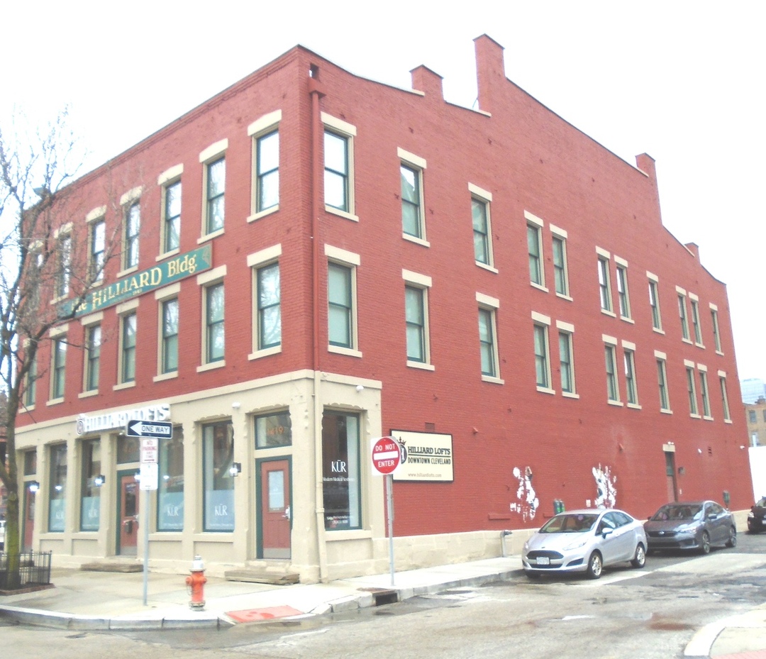
    <summary type="html"><![CDATA[<p><strong><em>Richard Hilliard achieved much as a businessman and civic leader in the thirty years (1826-1856) that he lived in Cleveland.  Most of his achievements have long since faded from the public's memory.  However, the three story brick building that he erected in 1850 still stands today on West 9th Street as a reminder to Clevelanders of who he was.</p></strong></p><img src="https://mail.clevelandhistorical.org/files/fullsize/f6a53caee7076de0abc61048028a060b.jpg" alt="Hilliard Building" /><br/><p>In Cleveland's Warehouse District, northwest of Public Square, the historic Hilliard Building stands on the corner of West 9th Street and Frankfort Avenue. A visitor to the area can't help but notice how isolated it is from other buildings. In fact, it is entirely surrounded by parking lots. There is a parking lot to the west of it, directly across West 9th Street. There is another to the south of it between Frankfort and the Brotherhood of Railroad Trainmen Building on Superior Avenue. And finally there is a very large parking lot that extends north from the Hilliard Building all the way to St. Clair Avenue and also to the east behind the building all the way to West 6th Street. </p><p>Such parking lots, when covering large areas of a city's downtown, have become known as "parking craters," a term popularized by blogger Angie Schmitt who wrote that they render urban landscapes "inhospitable and unattractive." How and why the Hilliard Building came to occupy such an isolated location on West 9th Street, in the middle of a "parking crater," is an important part of the history of this building. </p><p>The Hilliard Building is named after Richard Hilliard, who was born in Chatham, New York in 1800. When he was a teenager, Hilliard began working in dry goods stores in western New York. One of those stores opened a branch in Cleveland in 1824, locating its new store at the southwest corner of Water (West 9th) and Superior, across Superior from where the Western Reserve Building stands today. Two years later, Hilliard who had by then become a partner in that business, moved to Cleveland. He soon bought out his partner and then formed a new partnership with William Hayes, a dry goods merchant in New York City. At about the same time that they formed their partnership, Hilliard married Sarah Katherine Hayes, a sister of his new partner, not an unusual way to cement a business relationship in the nineteenth century. </p><p>The dry goods business of Hilliard and Hayes, according to Hilliard's biographers, soon became very successful, and Richard Hilliard developed into an important figure in Cleveland's early history. In 1830, he was elected President of the Board of Trustees of Cleveland Village, and in 1836, when Cleveland became a city, he was elected one of its first aldermen. In the decade of the 1830s, he was one of the developers of Cleveland Centre in the Flats, a bold, but ill-fated, effort to make Cleveland the center of international trade in the Midwest. In the 1840s, Hilliard and Henry B. Payne, became more successfully involved in the incorporation of the Cleveland, Columbus and Cincinnati Railroad, Cleveland's first railroad, both of them becoming directors of that railroad. (Payne, an attorney, later built the Perry-Payne Building on Superior Avenue in downtown Cleveland.) In the early 1850s, Hilliard served as the first president of the Cleveland Water Works Commission, which led to the creation of Cleveland's first public water works system in 1856. </p><p>In 1850, Hilliard built the three story brick commercial building which is the subject of this story, moving his dry goods business into the building in the same year. According to an article appearing in the Plain Dealer on June 27, 1851, the building had 48 and 1/2 feet of frontage on Water Street and 100 feet on Centre (today, Frankfort) Street. The interior of the building was arranged as follows. There was a dry goods room measuring 25 by 100 feet on the Centre Street side of the building, and rooms on the two upper floors of the building that were also used in the dry goods business. The balance of the front of the building consisted of a room approximately 21 by 80 feet which served as a grocery store. The rear 20 feet of that part of the building was "furnished and used as a Counting-room." </p><p>Hilliard and Hayes, which then became Hilliard, Hayes and Co., was, according to newspaper sources, the largest dry goods wholesale business in the Midwest in the 1850s. It provided dry goods to retail stores in Ohio, Michigan, Indiana, Illinois and Wisconsin, and had sales that annually exceeded $500,000, equivalent to almost $20 million in 2024 dollars. However, shortly after returning from a business trip to New York, Richard Hilliard died on December 21, 1856 from typhoid fever. He was only 56 years old. His death had a profound effect upon his wholesale business operated out of the Hilliard Building, then known as the Hilliard Block. Several new partnerships were formed with combinations of Hilliard's son Richard Jr. and several of his father's former partners, but none lasted. On March 22, 1858, an advertisement appeared in the Plain Dealer, offering the "stock . . . business and good will" of the company for sale. By 1860, a new wholesale dry goods firm, S. Raymonds & Co., was operating its business out of the Hilliard Block. </p><p>S. Raymond and Co. occupied the Hilliard Block as a tenant for more than a decade under leases from the Hilliard family who still owned the building. Then, in 1875, the building took on new tenants when it was remodeled as an office building for merchants in Cleveland's coal and oil trade. Among those new tenants in the building now known as the Coal and Iron Exchange Building was Rhodes and Hanna, a business started by prominent early west side industrialist Daniel Rhodes, but, following his retirement in 1867, operated by a partnership that included his son Robert Russell Rhodes and son-in-law Marcus Hanna. (Known to history as "Cleveland's kingmaker," Hanna later directed the successful 1896 and 1900 presidential campaigns of William McKinley.) From 1875 to 1887, a number of Cleveland's most prominent coal and iron merchants had their offices in the building. </p><p>In the mid to late 1880s, as new and grander commercial buildings were erected in the Warehouse District like the Grand Arcade (1883) and the Perry-Payne Building (1889), coal and iron merchants left the Hilliard Block for these more prestigious addresses. For a time, the Hilliard building then served as home to the offices of several stocks, grains, provisions and oil brokers. In the early 1900s, several related wholesale fire equipment and marine supply companies operated out of the building. In 1914, Laura Hilliard, the youngest daughter of Richard Hilliard, who had owned the Hilliard Building since the 1880s, sold it to Koblitz Brothers Realty Company, who, under several different corporate names, owned and leased it to various tenants until 1950. </p><p>During the 1920s, when Koblitz Brothers owned the Hilliard Building, the Warehouse District, according to local historian and archivist Drew Rolik, reached its pinnacle of commercial development and then began a slow decline as some of its aging buildings were, beginning in the mid 1920s, demolished to make room for parking lots. At first these new lots were few and far between, but the pace of parking lot creation increased following the end of World War II and the building of the interstate highway system which facilitated a massive movement of urban dwellers to the suburbs in the post war era. </p><p>In the 1950s, government officials like County Engineer Albert Porter advocated for more parking lots in downtown Cleveland to encourage suburban residents to come downtown to work and shop. His sentiments were echoed by business leaders like Alfred Benesch who, in a letter published in the Plain Dealer on April 21, 1957, wrote that the Warehouse District (then known as the Wholesale District or as part of the Garment District) was an ideal location for such parking lots as it was filled with "buildings a hundred or more years old . . . which are not any asset to Cleveland . . [and] might be well condemned and razed in order to provide parking facilities . . " </p><p>With encouragement like this from government and private sector leaders, the pace of building demolition and parking lot creation in the Warehouse District increased in the 1960s and 1970s. However, in the latter decade the tide began to turn as preservationists made their voices heard. In 1977, aided by a report from architect William A. Gould, the Cleveland Landmarks Commission adopted a comprehensive preservation plan for the Warehouse District. Five years later, in 1982, with the Commission's urging, the City of Cleveland created the Warehouse Historic District, which was later accepted and added to the National Register of Historic Places. By 1988, the Landmarks Commission felt comfortable in proclaiming victory for the preservation of the District. </p><p>According to Stephanie Ryberg-Webster in her book <em>Preserving the Vanishing City</em>, by the time victory was declared, more than a third of the buildings that were standing in Cleveland's Warehouse District in its peak year of 1921 had been demolished.  The result was the creation of a number of "parking craters" in the District, including the earlier mentioned one within which the Hilliard Building still stands today.  That crater began to form in the 1930s when a number of buildings on Frankfort Avenue between West 9th and West 6th were torn down, as well as a part of the Payne Brothers Building on the southeast corner of West 9th and St. Clair. In circa 1950, the old W. Bingham building across Frankfort from the Hilliard Building was torn down for a parking lot, and, as that decade progressed, more buildings were torn down on Frankfort, as well as a number on the west side of West 9th across the street from the Hilliard Building.  </p><p>The decade of the 1960s and 1970s saw additional buildings demolished on the west side of the West 9th Street, many of them as the result of fires of unknown origin.  And then, perhaps most notably for the Hilliard Building, one by one the buildings that lined the east side of West 9th immediately north of the Hilliard Building and south of St. Clair Avenue were demolished for parking lots.  The remaining part of the Payne Brothers Building was the first to go in 1966; the Vincent Block next door to it then was torn down in the 1970s; and finally the Board of Trades Building, the last building standing on that side of the street between St. Clair and the Hilliard Building, in the 1980s. By the time the dust settled and the Cleveland Landmarks Commission declared victory in stemming the tide of demolition, the Hilliard Building was left in the middle of the parking crater that it still occupies today, almost 40 years after victory was declared.</p><p>The Hilliard Building avoided the fate of the other nineteenth century buildings that once surrounded it, most likely for two reasons. First, in 1950, the building was purchased by two brothers, Sidney E. and Albert E. Saltzman, who, during the peak years of demolition in the Warehouse District, operated a successful wholesale business called Drug Sundries Co. out of the building. And second, in 1983, after the tide had turned toward preservation rather than demolition in the district, attorneys Stanley Yulish and Mark Twohig purchased the building from the Saltzmans; renovated and restored it; and moved their law firm into the building. </p><p>Since 2000, the Hilliard Building has been owned by several different limited liability companies, and in 2020 it was further renovated and remodeled in order to convert the second and third floors of the building into apartments. Now, in 2024, almost 175 years old, the Hilliard Building is not just downtown Cleveland's oldest commercial building.  It is also a remarkable survivor of the second half of the twentieth century in this city when, for a time, parking in the Warehouse District was king.</p><p><em><strong><a href="https://mail.clevelandhistorical.org/items/show/1018">For more (including 14 images) view the original article</a></strong></em></p>]]></summary>
    <published>2024-03-05T20:17:12+00:00</published>
    <updated>2026-04-17T19:17:43+00:00</updated>
    <link rel="alternate" type="text/html" href="https://mail.clevelandhistorical.org/items/show/1018"/>
    <id>https://mail.clevelandhistorical.org/items/show/1018</id>
    <author>
      <name>Jim Dubelko</name>
    </author>
  </entry>
  <entry>
    <title type="html"><![CDATA[Lorain-Fulton Square: Once the &quot;Hub of the West Side&quot;]]></title>
    <summary type="html"><![CDATA[<img src="https://mail.clevelandhistorical.org/files/fullsize/2e69c04a06dba37e0b0aba310b4f2ca6.jpg" alt="&quot;Next Stop . . .  Lorain-Fulton Square!&quot;" /><br/><p>Fulton Road is one of seven streets that were originally designed to radiate from Franklin Circle in accordance with the 1836 subdivision plat created by Ohio City pioneer real estate developers Josiah Barber and Richard Lord.  Starting at the Circle, it runs for one-half mile in a southwesterly direction, intersecting several grid streets at sharp angles, before terminating--at least until 1905--at Lorain Avenue  (then, Lorain Street).  It is unknown whether Barber or Lord envisioned it, but the original terminus of Fulton Road was destined to become one of the most commercially important corners on the west side of Cleveland in the late nineteenth and early twentieth centuries.</p><p>Eighteen years after Barber and Lord recorded their 1836 subdivision plat, Ohio City was annexed to Cleveland, becoming that city's west side.  At about the same time, German immigrants began arriving in Cleveland in large numbers and moving  onto streets in the Barber and Lord  and other  residential subdivisions located on lands north and south of Lorain, and west of West 25th Street (then, Pearl Street).  As the immigrant population swelled in these subdivisions, a neighborhood emerged and Lorain  Street  transformed into its commercial corridor.  Retail merchants of German origin built and occupied store fronts along the street's north and south sides, and, before long, both sides of Lorain Street were lined  with retail stores all the way to Cleveland's western corporation line which, in the post Civil War period, was just west of West 59th Street (then, Purdy Street).  </p><p>A number of these early west side retail stores were built at or near corners of the intersection of Lorain with Fulton and nearby Willett Street, a north-south grid street which began on the south side of Lorain just across the street from Fulton Road's terminus. (In 1905, Willett Street would be renamed Fulton Road, creating the much longer version of the latter road that Clevelanders know today.)  These two intersections (hereinafter, simply referred to as the Lorain-Fulton intersection) were from the start likely viewed by merchants as favorable places to conduct retail business.  As noted above, the Lorain-Fulton intersection was just a half mile down Fulton from Franklin Circle, where the west side's elite were already beginning to build the mansions that would one day make Franklin Boulevard (then, "Franklin Street") the "West Side's Euclid Avenue."  Moreover, the intersection was also just one-half mile down Lorain from the West Side Market, which had become, since it relocated to the northwest corner of Lorain and Pearl in 1859, a popular place where west siders gathered and shopped for their meat and produce.  </p><p>The early retail merchants who located their businesses at or near the Lorain-Fulton intersection included grocers,  butchers, shoe makers, saloon keepers, tobacconists, bakers, confectioners, milliners and tailors, to name just a few.  A survey of period directories suggests that business failures among these merchants  were frequent and it wasn't unusual for a merchant to sell one type of product one year and then an entirely different one the next.  Two of the early merchants who located at or near the intersection, however, are noteworthy for establishing retail businesses that thrived for decades.  One was Henry Leopold, a German immigrant from Hanover, who, in 1859, opened up a store near the southeast corner of the  intersection where he initially manufactured and sold furniture and caskets.  Eventually, his company would leave the casket business and devote its full attention to making and selling furniture.  Leopold's store was a neighborhood fixture until the 1940s when it relocated to Cleveland's West Park neighborhood and, after that, to the suburb of Brecksville where it is still in business today.   The other notable early merchant at this intersection was George Tinnerman, a German immigrant from Bavaria, who opened a hardware and stove store on the northeast corner in 1868.  Tinnerman later developed a steel range stove which  became so popular that, after operating his retail business at the Lorain-Fulton intersection for almost four decades, he  finally closed it  in 1915 to focus exclusively on manufacturing steel range stoves at a factory he built on Fulton Road just south of the Lorain-Fulton intersection.</p><p>In 1879, the businesses of Henry Leopold, George Tinnerman and the other merchants engaged in the retail sale of products or services at or near the Lorain-Fulton intersection were boosted when the West Side Street Railway (WSSR), then controlled by Marcus Hanna, bested Tom Johnson's Brooklyn Street Railway and secured a license from Cleveland City Council to build and operate a new branch of the WSSR streetcar system on tracks which soon ran south on Fulton from Franklin Circle to Lorain and then west on Lorain Chestnut Ridge (today, West 73rd) Street. Later, that new branch was additionally connected to the WSSR main line by a separate track which ran from the Lorain-Fulton intersection to Pearl Street.  As more and more streetcar riders hopped on, got off or waited for a transfer at the Lorain-Fulton intersection, the businesses of nearby merchants grew as evidenced by the construction  of many larger and more grand commercial buildings at or near the intersection in the decades that followed.</p><p>In the early twentieth century, another change came to the Lorain-Fulton intersection that reflected its continued vitality and key location on Cleveland's west side.   Between 1903 and 1905, the Cleveland Public Library, armed with a promise of funding from Andrew Carnegie, conducted a search for a site for its new West Side branch library.  A number of sites at or near prominent West Side intersections were considered, including one at the intersection of Lorain and West 25th near the West Side Market and another at the junction of Lorain and Clark Avenues.  The Board, however, ultimately chose a site  on Fulton Road less than a tenth of a mile north of the Lorain-Fulton intersection.  The new Carnegie West branch library opened in 1910.  It was then, and still is today, the largest of Cleveland Public Library's branch libraries.  </p><p>In the same year that the new library opened, the City of Cleveland, spurred by the example of New York City, began naming a number of its more notable diagonal intersections "squares." (For example, the diagonal intersection of Huron Road and Euclid Avenue in downtown Cleveland was named "Euclid Square" in1910. It was later renamed "Playhouse Square" in 1921 when theaters began to locate there.)  While it is not known whether the City of Cleveland ever officially named it a square, the Lorain-Fulton intersection became popularly known on the West Side as "Lorain-Fulton Square" in this decade, likely as the result of a number of actions taken by merchants with stores located at or near the intersection.  In 1914, a number of these merchants, including George Tinnerman and Henry Leopold's son August, formed the Lorain-Fulton Square Business Association to further their mutual business interests and promote the area as a great place for west siders, including those on west side street cars, to shop for all of their family and other needs.  In 1915, the merchants sponsored a contest to create a slogan for their business area.  The winning slogan was "The Hub of the West Side." The merchants later used that slogan repeatedly in "Opportunity Ads" that promoted their stores and advertised their "bargain" sales.</p><p>The 1920s opened with another sign  of the continuing commercial vibrancy of  the Lorain-Fulton intersection. On December 25,1921, John and Bertha Urbansky opened their beautiful new Lorain-Fulton Theater at 3321-3409 Lorain Avenue, adjacent to Leopold's four-story furniture store on the intersection's southeast corner.  The theater seated 1,400 patrons; had a dance hall on the second floor; and had  storefronts for retail businesses.   In the years that followed, the intersection remained an active and busy commercial area, but as streetcars declined and automobile traffic increased, as upper- and middle-class residents (and the businesses that catered to them) moved to the suburbs, and as the city's deindustrialization began in the post World War II era, Lorain-Fulton Square began to lose many of its shoppers. By the 1950s, historic commercial buildings at or near the intersection were already beginning to show signs of  deterioration and neglected maintenance.   A number of them were torn down and replaced by parking lots, gas stations or fast-food restaurants which better served the needs of the more mobile--and more transient--population now frequenting  Lorain-Fulton Square.</p><p>At least since 1993, when the Cleveland Landmarks Commission cataloged historic buildings on Lorain Avenue between West 32nd and West 58th Streets during the process that created the Lorain Avenue Commercial Historic District, the City has been aware of the extent of the deterioration and loss of historic buildings at or near Lorain-Fulton Square.  Before Landmarks Commission intern Don Petit walked up and down Lorain Avenue in that year, snapping photos of the historic buildings, many historic buildings were already lost--burned down, torn down or perhaps blown down in the 1953 Tornado.  The photos he took were part of a City effort to save  the remaining historic buildings. Many of the buildings that were still standing at or near the intersection of Lorain and Fulton when Petit walked the area in 1993, no longer are.  Lorain Fulton Square has become a very different place than it was one hundred or even thirty years ago.  </p><p>While other prominent West Side intersections such as Detroit Avenue -West 25th Street and Lorain Avenue -West 25th Street have for decades  garnered  attention from redevelopers resulting in the preservation of a number of historic buildings in those areas being saved, Lorain-Fulton Square has not.  In 2022,  however, there is reason for hope as Lorain Avenue west of West 25th Street is beginning to get redevelopment attention.  While little of that attention has yet come to  Lorain-Fulton Square itself, it seems inevitable that it soon will.  It would be fitting to honor the rich commercial history of this historic intersection with redevelopment that recalls and reflects some of the height, massing and location of significant historic buildings.  This would seem to be good for business branding. It would also instill some pride in new business owners operating there, as well as new residents choosing to live there, as they came to learn that Lorain-Fulton Square was at one time, and for good reason, known as the "Hub of the West Side." </p><p><em><strong><a href="https://mail.clevelandhistorical.org/items/show/966">For more (including 21 images) view the original article</a></strong></em></p>]]></summary>
    <published>2022-09-30T14:36:48+00:00</published>
    <updated>2026-04-17T19:17:42+00:00</updated>
    <link rel="alternate" type="text/html" href="https://mail.clevelandhistorical.org/items/show/966"/>
    <id>https://mail.clevelandhistorical.org/items/show/966</id>
    <author>
      <name>Jim Dubelko</name>
    </author>
  </entry>
  <entry>
    <title type="html"><![CDATA[Shaker Town Center: Redeveloping Moreland&#039;s Historic Shopping Center]]></title>
    <summary type="html"><![CDATA[<p><strong><em>Beginning in the late 1950s, the City of Shaker Heights took a number of  actions designed to keep the Moreland neighborhood's historic shopping center at the intersection of Chagrin Boulevard and Lee Road vibrant and a favored place for Shaker Heights shoppers.  Among these were renaming it Shaker Town Center in 1984 and promoting it as the city's downtown shopping district.  But what the city proposed to do in 1987 was perhaps the most extraordinary of all.</p></strong></p><img src="https://mail.clevelandhistorical.org/files/fullsize/4e26154b7b22400af09b5485d439b2a1.jpg" alt="Shaker Towne Centre  " /><br/><p>The history of commercial activity at the intersection of Chagrin Boulevard and Lee Road  goes back more than 150 years to when the area was still part of Warrensville Township.  In or about 1866, at the northeast corner of the intersection--where the Shaker Town Center Convenience Shopping Center now stands--Alonzo and Rachel Gillette opened a tavern which for decades served people traveling on the Kinsman plank road to and from Cleveland and other cities.  Retail shopping stores, however, at or near the intersection, did not appear until much later.</p><p>In 1920, as a result of the annexation of East View village to Shaker Heights, the intersection, which was by this time called Kinsman-Lee Corners, became part of the Van Sweringen brothers' planned suburb.  The first retail businesses located at or near the intersection were operated out of a string of  houses on the north side of Kinsman Road (Chagrin Boulevard), east of Lee Road.  According to a 1923 Cleveland Directory, one of the earliest of these was a grocery store owned by Czech immigrants John and Ella Buzek at 16611 Kinsman.  Buzek's grocery store operated for only a few short years before the land upon which it sat was sold and the house razed to make room for a one-story brick commercial building erected on the northeast corner in 1925.  The Kinlee Building, with seven store fronts facing Kinsman Road and five facing Lee Road, was home to a number of early Shaker Heights retail stores, including Shaker Heights Hardware Store, one of the city's oldest extant retail businesses.  </p><p>Other commercial buildings soon followed at or near this intersection, which a Plain Dealer article in 1926 called one of the fastest growing commercial areas in Cuyahoga County.  Notable among them was the Lee-Kinsman Building, erected on the northwest corner of the intersection in 1929.  Located on land previously owned by the Van Sweringens, it was one of only a few of the early-era commercial buildings at Kinsman-Lee Corners that reflected the Van Sweringens' exacting  standards. Two stories tall, and with a semi-circular facade that fronted both Kinsman and Lee Roads, it was designed by the same architectural firm responsible for Shaker Square.  </p><p>By 1931, the area surrounding the intersection, with its rich assortment of commercial retail buildings on Kinsman and Lee Roads, was now being referred to as the Kinsman-Lee Shopping Center. For many years thereafter, it was a vibrant retail shopping place for Shaker residents, featuring such well-known past and present Shaker businesses as Heinen's grocery store, Kinsman-Lee Bowling, Shaker Theater, The Village Market, Glin's Grocery and Meat Market, Horton's Jewelers, Budin's Delicatessen, Sol's Delicatessen, Chin's Kin Lee Restaurant, Leonello's Restaurant, Gays Shoe Store, F.W. Woolworth, Lota Kelly Sportswear, Baskin-Robbins, Hough Bakery, Just Rite Cleaners, and C.C. Nicholls Sporting Goods, just to name a few. However, by the mid 1950s, its early twentieth century urban design featuring store fronts located close to the street and limited off street parking made it obsolescent. Adding to the shopping center's woes was neglected maintenance by building owners, a matter which the local merchants association complained about to the city as early as 1957. Matters only worsened when the 1960s decade arrived and the first regional shopping malls to the north and east opened, drawing Shaker shoppers out of the city. Finally adding to the city's and merchants' concerns was ongoing racial transition in the southwestern neighborhoods of the city, which was seen as contributing to white flight from the shopping center.</p><p>Concerns over the negative impact that these conditions at the Chagrin-Lee-Avalon Shopping Center--as the retail shopping area was now called following the name change of Kinsman Road in Shaker Heights  in 1959--led the city government to take action, initially to protect its tax base, but later also to attempt to preserve the integrated status of its southwestern neighborhoods.  One of the first actions it took was, in 1960, to purchase the deteriorating Kinlee Building, located on the northeast corner of the Chagrin-Lee intersection. The building was razed and the land sold to a developer who built Chagrin-Lee Plaza, a two and one-half story commercial and medical office building which was set back from the intersection in order to provide more off street parking for patrons.  In the years that followed, the city took additional actions, including actively working with the Chagrin-Lee-Avalon merchants association to improve the the shopping center area. These collaborative efforts included streetscape improvements, additional off street parking, low cost building improvement loans, free planning services, and the "Be a Shaker Shopper" public relations program. In 1984, the city and merchants association also took the dramatic step of rebranding the entire shopping center as  Shaker Town Center and promoting it as the city's downtown shopping center.  </p><p>Despite all of these actions,  however, by 1987 the city had concluded, based on studies by the Cuyahoga County Regional Planning Commission and various other planners consultants, and the report of the Shaker Towne Centre Citizens Advisory Committee appointed by Shaker Heights Mayor Stephen J. Alfred, that a more radical change was needed.  In order for the Chagrin-Lee-Avalon Shopping Center to become competitive with nearby regional shopping centers and malls, and bring Shaker residents--particularly white residents--back to the shopping center, it would be necessary to extensively rebuild the center and provide for its ownership and operation by a single business entity. Accordingly, the city proposed to purchase ten acres of shopping center properties on the northeast corner of Chagrin Boulevard and Lee Road, raze the buildings, and sell the land to a developer to build and operate a convenience shopping center there.</p><p>Shortly after it was made public, the city's redevelopment proposal was met with opposition from a number of retail business owners, some of whom alleged that the purpose behind it was to remove African American merchants and African American shoppers from the center. Thereafter, in June 1989, when Shaker Heights city council authorized the city administration to proceed with the redevelopment proposal, several of the objecting business owners and a self-styled "tax fighter" gathered signatures and filed initiative petitions with the city, seeking to roll back local taxes and to renovate, rather than redevelop, Shaker Town Center. In the November 1989 election, both initiatives were soundly defeated, permitting the city to proceed as planned. During the period 1990-1992, all land purchases were made, the site was cleared, a developer was selected, and the new convenience shopping center was built, featuring as its anchor tenants long-time Shaker businesses, Heinen's Grocery Store and Shaker Heights Hardware Store.  </p><p>The new convenience shopping center of Shaker Town Center has now operated on the northeast corner of Chagrin Boulevard and Lee Road for a quarter of a century. Changes have been made to it over the years, including the construction of a north-south street through the center to provide better access to Van Aken Boulevard as well as to the retail stores on the south side of Chagrin Boulevard.  At least one scholar has criticized the redevelopment, because of its emphasis on higher-end stores designed to attract a higher economic class of shopper, as well-intentioned, but, given the close proximity of Cleveland's Mount Pleasant neighborhood to the shopping center, economically wrong-headed. A survey of local newspaper articles, however, suggests that the redevelopment of the shopping center has been largely viewed by the general public as a success and Shaker Town Center has served as a model for at least one other Cleveland suburb seeking to reinvigorate its aging retail center.   </p><p><em><strong><a href="https://mail.clevelandhistorical.org/items/show/834">For more (including 15 images) view the original article</a></strong></em></p>]]></summary>
    <published>2018-04-25T05:15:22+00:00</published>
    <updated>2026-04-17T19:17:41+00:00</updated>
    <link rel="alternate" type="text/html" href="https://mail.clevelandhistorical.org/items/show/834"/>
    <id>https://mail.clevelandhistorical.org/items/show/834</id>
    <author>
      <name>Jim Dubelko</name>
    </author>
  </entry>
  <entry>
    <title type="html"><![CDATA[Cushing Building: Birthplace of America&#039;s First Neurosurgeon]]></title>
    <summary type="html"><![CDATA[<img src="https://mail.clevelandhistorical.org/files/fullsize/e5352f971577620bb2e50fe7e73ca81f.jpg" alt="The Cushing Building" /><br/><p>Though he has been called America’s first neurosurgeon, Dr. Harvey W. Cushing was not the first American to perform brain surgery.  Others did before him, piercing the dura which encases the brain in order to attempt to remove tumors, but the results were almost always disastrous for the patient.  With his pioneering use of local anesthesia, innovative methods to control bleeding and oxygen levels in the brain, and his skilled hands as chief surgeon at Johns Hopkins, Harvard and Yale University hospitals from 1896 to 1939, Harvey Cushing revolutionized the field, conducting highly successful operations and dramatically reducing the odds of patient mortality during such operations.  One of his biographers compared Cushing's contributions in the field of neurosurgery to those of Sigmund Freud in psychiatry.</p><p>Harvey Cushing was born in Cleveland on April 8, 1869, in a house that sat on the site where the Cushing Building at 224 Euclid, built by his father, sits today.  Harvey was a fourth-generation physician who knew and benefited from the experiences of both his father and grandfather, early leading medical practitioners here.  Dr. Erastus Cushing, Harvey's grandfather, was born and grew up in Cheshire, Massachusetts, not far from the New York state line.  He migrated to Cleveland in 1835, and in 1839 purchased a house on the south side of Public Square, east of Ontario Street, where the May Company building now sits.  He and his family resided there, and he conducted his medical practice at that location, for the next three decades.  Dr. Henry Kirke Cushing was the son of Erastus and the father of Harvey.  Henry trained in Cleveland and Philadelphia to become a doctor, and entered into practice with his father in 1851.  By 1860, he was married with children, and living just up the street from his parents in the house on Euclid Avenue where his son Harvey, the youngest of his 10 children, would be born nine years later.</p><p>While Cleveland had certainly changed from the time when Erastus Cushing arrived here in 1835 until the time when his Henry son moved into that house just up the street on Euclid Avenue in 1860, the south side of Public Square and lower Euclid Avenue (from the Square to East 9th Street) had remained essentially a residential neighborhood.  That began to change during the Civil War and postwar period, when, as the Cleveland Leader put it in a March 10, 1870 article, business interests on Superior Avenue and Ontario Street “crept across the open space” of Public Square and began erecting commercial buildings on the south side of the  Square and on both sides of Euclid Avenue.  The Cushing family certainly contributed to that change.  In 1868, the year his wife died, Erastus Cushing razed his house on the south side of the Square and built in its place the Cushing Block, a beautiful four-story brick building with Amherst sandstone ornamentation, designed by the architectural firm of Heard & Blythe and completed in 1869.  One of the building’s  first tenants was the Standard Oil Company, just recently founded by John D. Rockefeller.  Erastus Cushing too was a tenant in the building, keeping a medical office there, while living as one of the "regular boarders" in the nearby Forest City Hotel on the west side of Public Square, where the Renaissance Cleveland Hotel sits today.</p><p>In 1873, Henry Cushing moved his family, including 4-year-old son Harvey, uptown to a new house on fashionable Prospect Avenue near Sterling (East 30th) Street. The following year he tore down his house on Euclid Avenue and put up in its place the Cushing Building, a four-story brick commercial building that in its architectural style very much resembled the building which his father had built five years earlier.  The Cushing Building (which is only 36 feet wide, though 215 feet deep) was connected by a party wall to the wider Cobb Building, built at the same time, giving the appearance that the two were one larger building.  (The Cobb Building was torn down in 1940 to make room for the new W. T. Grant store.)  In addition to the Cushing Block and the Cushing and Cobb Buildings, two additional similarly-styled buildings--the Euclid Avenue Block and the Hardy Block--were erected in this period between what are today East 1st and East 3rd Streets, completing the transformation of that part of the south side of Public Square and lower Euclid Avenue from a residential to a commercial neighborhood.</p><p>Dr. Henry Cushing kept a medical office in the Cushing Building, as did other Cleveland physicians, from 1874 until his semi-retirement in 1893, the year his father Erastus died.  He then turned occupancy of the entire building over to the George H. Bowman Co., an imported china and glassware store, pursuant to the terms of a 99-year lease. Harvey Cushing's share of the income from this and other long-term leases of downtown commercial properties owned by his father and the estate of his grandfather would be a major source of his income not only in his early years as a young physician, but even later when he was world-famous, yet paid only a modest salary by the university-owned hospitals that employed him. </p><p>The George H. Bowman store that took over occupancy of the Cushing Building in 1893 was a fixture on lower Euclid Avenue for the next four decades, but in 1932 it was forced to close its doors as a casualty of the Great Depression. The Cushing Building was afterwards leased by the Cushing family to several other retail businesses, and then in 1937 to the Coles Shoe Store which dramatically altered the appearance of the building by adding to its facade an art deco-style marble and granite stone covering.  In 1948, Coles Shoes' parent company purchased the building from the Cushing family. The building was thereafter known as the Coles Building until 1983, when Baker Shoes replaced Coles Shoes. The building then became known as the Baker Building until 1997 when that shoe store closed. </p><p>Over the next several years, the Cushing Building sat vacant while a plan for the redevelopment of it and the nearby W. T. Grant Buildngs as an apartment complex materialized. According to city records, in 1999 the marble and granite art-deco covering was removed from the Cushing Building.  In 2003, the redevelopment project was completed and the Cushing Building became a part of the new W. T. Grant Loft Apartments. Today, the upper floors of the Cushing building are luxury apartment lofts while the first floor is occupied by a restaurant. Clevelanders who walk past the building on their way from Public Square up Euclid Avenue can admire it as one of the last surviving examples of high Victorian Gothic architecture on lower Euclid Avenue, as well as the site of the birthplace of America's first neurosurgeon.</p><p><em><strong><a href="https://mail.clevelandhistorical.org/items/show/814">For more (including 12 images) view the original article</a></strong></em></p>]]></summary>
    <published>2017-10-05T09:24:17+00:00</published>
    <updated>2026-04-17T19:17:41+00:00</updated>
    <link rel="alternate" type="text/html" href="https://mail.clevelandhistorical.org/items/show/814"/>
    <id>https://mail.clevelandhistorical.org/items/show/814</id>
    <author>
      <name>Jim Dubelko</name>
    </author>
  </entry>
  <entry>
    <title type="html"><![CDATA[Campbell Block: Gone, but still remembered in the Old Angle]]></title>
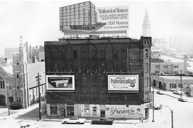
    <summary type="html"><![CDATA[<p><strong><em>On September 19, 1975, the late George Condon, legendary Plain Dealer columnist and author of many books about Cleveland's history, wrote that the Campbell Block--condemned and slated for imminent demolition, was unworthy of historical recognition and should not be saved.  "If there is anything historic about the Campbell Block it would have to be the historic drinking and arguing that took place in Green's Cafe at the street level, or in the furious thumping and rope-skipping that occurred in the Old Angle Gymnasium, on the High Level Bridge side of the building,"  he wrote.  With all due respect to George Condon, the Campbell Block had a richer history than his column suggested.</em></strong></p><img src="https://mail.clevelandhistorical.org/files/fullsize/5782d97ac9360feaf3f917923f0d1f59.jpg" alt="The Campbell Block" /><br/><p>The Campbell Block was for many years one of the most recognizable buildings in the Old Angle neighborhood on Cleveland's near west side.   It was actually at one time two separate buildings located just east of Pearl (West 25th) Street, between Vermont and Viaduct Avenues.  Both were built by Alexander Campbell and both came about as a result of the construction of the Superior Viaduct, Cleveland's first high level bridge, which opened to traffic in 1878. In the course of planning construction of the west side approach to the Viaduct, the City had purchased an eighty foot wide swath of land (part of the Alonzo Carter Allotment) located just east of the intersection of Pearl Street and Vermont Avenue. This purchase split a number of parcels of land and, among other things, created a triangular piece of land with frontage on Pearl Street, Vermont Avenue and the new Viaduct Avenue. During the period 1877-1882, Campbell, a Scottish immigrant who had settled in Cleveland in 1867 and had become a prominent paving contractor in the city, purchased all of the land interests which comprised the triangular area with the intent of constructing a commercial building and hotel on the land.</p><p>Campbell's first building, identified on early maps as "Campbell's Block" and located on the eastern part of the triangular piece of land, was a three-story wood and brick building which fronted on Viaduct Avenue.  It was completed in 1880. The upper two floors were devoted to apartment suites, while the first floor was divided into seven store fronts for retail merchants, among whom over the years were butchers, confectioners, cigar-makers, barbers, saloon keepers and others.  One of those store fronts was home to the offices of the Cleveland Graphic, a weekly Democrat newspaper. And, in 1886, according to the Plain Dealer, this was where Charles Salen, co-owner of the Graphic and County Democrat party leader, organized Cleveland's first amateur baseball league, which played its games on the southeast side at Beyerle's Park (later called Forest City Park) for several years, before moving to Brookside Park on the west side.</p><p>The second Campbell Block building—which many Clevelanders still remember—was built in 1892, just to the west of the first building.  It was a red brick five-story building that was originally planned as a hotel, but became instead an apartment building with retail store fronts on the first floor. This building had frontage on both Viaduct Avenue and Pearl Street. In 1897, the building received acclaim for its innovative fire escape system—called the "Burden" fire escape, which enabled fire fighters to extract people from a burning building using a wire basket hauled along rails attached to projections from the roof and exterior sides. This new fire escape had been promoted and installed on the building by Isaac Kidd, Alexander Campbell's son-in-law and the father of the future-famed World War II war hero, Admiral Isaac Campbell Kidd. Like the first building, this building also had a variety of retail tenants on the first floor.  In the post World War II era, the most famous of these in the neighborhood were J & L Seafoods, Green's Cafe, and the Old Angle Gym.</p><p>By the time World War II arrived, Alexander Campbell's heirs now owned and managed the two Campbell Block buildings. In 1948, the first building--said by one County official to be in "very poor shape," was torn down and in the same year the second was conveyed out of the family.  Gradually, as the surviving building aged and deteriorated, it emptied of its apartment residents and became--from a revenue perspective, primarily a site for billboard signs.  It's three locally famous first floor tenants—J & L Seafoods, Green's Cafe, and the Old Angle Gym, however, continued to operate their businesses there until the very the end.  That end came in late December 1975 when a wrecking ball knocked down the building, demolishing  the Block that the Superior Viaduct and Alexander Campbell had created almost 100 years earlier.</p><p><em><strong><a href="https://mail.clevelandhistorical.org/items/show/749">For more (including 11 images) view the original article</a></strong></em></p>]]></summary>
    <published>2015-11-28T15:00:51+00:00</published>
    <updated>2026-04-17T19:17:41+00:00</updated>
    <link rel="alternate" type="text/html" href="https://mail.clevelandhistorical.org/items/show/749"/>
    <id>https://mail.clevelandhistorical.org/items/show/749</id>
    <author>
      <name>Jim Dubelko</name>
    </author>
  </entry>
  <entry>
    <title type="html"><![CDATA[Kingsbury Building: A Self-Contained Commercial District Along the Shaker Rapid]]></title>
    <summary type="html"><![CDATA[<img src="https://mail.clevelandhistorical.org/files/fullsize/8b374a13c19160681653db43735b677e.jpg" alt="Kingsbury Building" /><br/><p>From its founding, Shaker Village was planned as a highly-regulated residential district. Promotional literature distributed by the Van Sweringen Co. offered prospective land buyers the security of a community that existed outside the influence of the urban environment. A strictly defined and governed landscape promised safety and order in a village that was both designed and advertised as a contrasting vision to the City of Cleveland. The Kingsbury Building, designated a Shaker Heights Landmark in February 1998, is an example of the small commercial zones that were integrated into this vision for the Van Sweringen's suburb. These centers of commerce were carefully designed to meet the needs of a growing population without undermining the residential character of the surrounding community.    </p><p>In an era coinciding with the emergence of formal zoning, urban centers were characterized by their mixed use.  Much of the urban core of Cleveland was a clutter of industry, homes, and commercial buildings. Those with the means to leave these polluted and congested spaces moved from the city center. Elite residential districts, most notably the row of mansions lining Euclid Avenue, found themselves susceptible to the continuing advances of the physical city. Little could be done to prevent Cleveland from swallowing these exclusive neighborhoods – homes were often converted into businesses or fell into disrepair. Within this context, the Van Sweringen Co. created a community that would stand the test of time through strict regulation. Standards imposed by the real estate developers were meant to ensure the financial soundness of land purchases in their utopian residential retreat.   </p><p>The Van Sweringen Co. first busied themselves with promoting the development of amenities that would act as the foundation for their elite community, including schools, public transportation, green space, churches and recreational facilities. Apartments, industry, bars and corner shops were initially excluded due to their association with urban life. By the 1920s, however, the need for commercial structures and more diverse housing stock became apparent. The costly rapid transit system built by the Van Sweringens not only provided new opportunities for people to relocate to Shaker, but also necessitated a larger population to sustain its existence. The Van Sweringen Co. quickly integrated the development of apartments and business districts into their planned community. Staying true to their vision of a residential suburb, these structures were strategically placed on the outskirts of the community along heavily used transportation routes.  </p><p>The Kingsbury Building was one of the early commercial structures and apartment buildings in Shaker Heights. The self-contained business district was conceived and designed using similar standards as those imposed by the Van Sweringen Co. upon residential construction.  Erected by the Leemore Company between 1926-1927 at what is now 3427-55 Lee Road, the prestigious architectural firm of Walker and Weeks was employed to design the multipurpose building.  Similarly to other commercial structures concurrently being constructed at Shaker Square, the Kingsbury Building was designed in the Tudor style. Prominently located at the intersection of Moreland Boulevard (now Van Aken) and Lee Road, the angled corner building presented a unified vision from the front with its recessed entrances and symmetrical design. Bounded by comparatively smaller residential lots on the southern edge of the city, the business district was placed near a Rapid station and away from more prestigious residential neighborhoods. The three-story edifice provided space for ten storefronts, eight offices and sixteen apartments. </p><p>During the early years of growth in Shaker, the Kingsbury Building was one of only a few locations where residents could purchase commercial goods and employ professional services. Early tenants included the Fisher Bros. Co., a jewelry shop, a beauty shop, a florist, the Village Drug Store, the Shaker Heights Electric Co., a fruit shop, a shoe repair shop, a dry cleaner, a delicatessen, and the Western Union office.  Offices were regularly occupied by dentists, physicians, and real estate agents.  </p><p>While the Kingsbury Building was an inevitable response to the needs of a growing population, its form, placement, and usage were dictated by the standards created by Shaker Height's developers.  In this manner, the Van Sweringen Co. promoted growth and provided conveniences to the residential community while maintaining their promise to keep the influences of the city at bay.</p><p><em><strong><a href="https://mail.clevelandhistorical.org/items/show/370">For more (including 8 images) view the original article</a></strong></em></p>]]></summary>
    <published>2011-12-19T23:34:52+00:00</published>
    <updated>2026-04-17T19:17:38+00:00</updated>
    <link rel="alternate" type="text/html" href="https://mail.clevelandhistorical.org/items/show/370"/>
    <id>https://mail.clevelandhistorical.org/items/show/370</id>
    <author>
      <name>Richard Raponi</name>
    </author>
  </entry>
  <entry>
    <title type="html"><![CDATA[Gordon Square Arcade: A District&#039;s Namesake]]></title>
    <summary type="html"><![CDATA[<img src="https://mail.clevelandhistorical.org/files/fullsize/180d212a73d010c18dffe0bfa2193fad.jpg" alt="The Gordon Square Arcade" /><br/><p>The Gordon Square Arcade opened to the public on April 8, 1921. The unique and massive structure quickly became the centerpiece of the Gordon Square commercial district, and a source of pride for the surrounding neighborhood. The monumental building was not only constructed to meet the needs of the community, but acted as a reflection of the neighborhood's growth into a commercial center. In part, the success and growth of Gordon Square, and the choice to build the arcade on the corner of West 65th and Detroit Avenue, was due to its location. Interurban and crosstown streetcars not only provided Clevelanders access to the Gordon Square area. It also attracted residents from the developing communities of Rocky River and Lakewood. </p><p>Construction of the arcade took about one year to complete, and cost $1,500,000. The Gordon Square Arcade and Community Building included a seventy-five room hotel, a seventy-five stall market, a pool and billiard room, the Capitol Theatre, seventy offices, thirty-one stores, a barber shop, and a restaurant. </p><p>The Gordon Square Arcade remained the heart of a healthy commercial district until the middle of the 20th century, when post war affluence and the construction of highways played their part in promoting a mass exodus of residents, businesses, and industry from the City of Cleveland to the suburbs. New waves of settlers into Cleveland would never again match the numbers of those leaving, and the population began to plummet. Businesses left behind vacant storefronts, factories moved away, and the commercial district slowly began to deteriorate. In what is now considered the Detroit Shoreway neighborhood, these changes culminated in the collapse of the Gordon Square Arcade's parapet onto West 65th Street in 1978.</p><p>Through the efforts of citizen groups and the Detroit Shoreway Community Development Organization, the Gordon Square Arcade was saved from demolition and rehabilitated. In the process, the arcade once again became the centerpiece of Gordon Square and helped reestablish the intersection of West 65h Street and Detroit Avenue as a commercial district. A symbol of the possibilities of urban redevelopment, the Gordon Square Arcade has become a model for efforts to revitalize the Detroit Shoreway neighborhood.</p><p><em><strong><a href="https://mail.clevelandhistorical.org/items/show/211">For more (including 7 images) view the original article</a></strong></em></p>]]></summary>
    <published>2011-06-01T17:35:11+00:00</published>
    <updated>2026-04-17T19:17:37+00:00</updated>
    <link rel="alternate" type="text/html" href="https://mail.clevelandhistorical.org/items/show/211"/>
    <id>https://mail.clevelandhistorical.org/items/show/211</id>
    <author>
      <name>Richard Raponi</name>
    </author>
  </entry>
  <entry>
    <title type="html"><![CDATA[Cedar Fairmount: Gateway to the Heights]]></title>
    <summary type="html"><![CDATA[<img src="https://mail.clevelandhistorical.org/files/fullsize/8764896812d641b262817602e9471ad8.jpg" alt="Heights Center Building, ca. 1935" /><br/><p>Cedar Fairmount, the residential and commercial neighborhood where eastbound Cedar Road forks into Cedar to the left and Fairmount to the right, emerged as the "gateway to the Heights" as early as 1918 when the Tudor-style Heights Center Building opened on the north side of Cedar Road between Lennox and Surrey roads. Taking advantage of its streetcar connection to Cleveland via <a href="https://clevelandhistorical.org/items/show/547">Cedar Glen</a>, the district grew rapidly in the 1920s, with new storefronts and apartment buildings erected throughout the decade. For many years Heights Medical Building and Doctors' Hospital (which stood slightly southeast of the Buckingham Condominiums where Euclid Heights Boulevard intersects with Cedar Road) made the area a medical hub. </p><p>Cedar Fairmount's growth was further buoyed by Barton Deming's development of <a href="https://clevelandhistorical.org/items/show/533">Euclid Golf</a>, an upscale neighborhood bounded roughly by the Cedar-Fairmount intersection to the west, Cedar Road to the north, North Park Boulevard to the south, and Coventry Road to the east. A large percentage of Deming's development was previously occupied by the Euclid Golf Club, whose property (owned in part by John D. Rockefeller) also stretched west into the Cedar Heights neighborhood, whose streets include Grandview and Bellfield Avenues. Euclid Golf Club closed in 1912. Not surprisingly, Demington Drive takes its name from Barton Deming.</p><p>Concerns about the "aging" of Cleveland Heights led to plans for a massive redevelopment of Cedar Fairmount in 1969. The renewal's cornerstone was to be called Surrey Place, a combination of high-rise and garden-type apartments, connected to a proposed Cleveland Transit System (CTS) rapid transit spur to Severance Center. The plan failed, but a half century later, following lengthy public debate, the "Top of the Hill" project got underway in 2021.</p><p><em><strong><a href="https://mail.clevelandhistorical.org/items/show/198">For more (including 10 images, 4 audio files,&#32;&amp;&#32;1 video) view the original article</a></strong></em></p>]]></summary>
    <published>2011-04-21T14:15:31+00:00</published>
    <updated>2026-04-17T19:17:37+00:00</updated>
    <link rel="alternate" type="text/html" href="https://mail.clevelandhistorical.org/items/show/198"/>
    <id>https://mail.clevelandhistorical.org/items/show/198</id>
    <author>
      <name>Michael Rotman</name>
    </author>
  </entry>
  <entry>
    <title type="html"><![CDATA[Gordon Square]]></title>
    <summary type="html"><![CDATA[<img src="https://mail.clevelandhistorical.org/files/fullsize/detroitshoreway-dscdo-w65th-and-detroit-shows-city-grill-nd_b3d18a7ea4.jpg" alt="West 65th Street and Detroit Avenue" /><br/><p>Located at the intersection of W. 65th Street and Detroit Avenue, Gordon Square is the historic commercial district of the Detroit Shoreway neighborhood.   As residential construction and industry grew along and away from Detroit Avenue following the turn of the 19th century, the Gordon Square commercial district emerged to meet the retail, recreational, and service needs of the surrounding community. The construction of the Gordon Square Arcade and Community Building symbolized the prominence of this bustling community. Encompassing an entire city block, the Gordon Square Arcade was the largest construction project to have taken place on the West Side at the time of its opening in 1921.  The arcade quickly became the heart of the Gordon Square commercial district.   </p><p><em><strong><a href="https://mail.clevelandhistorical.org/items/show/146">For more (including 6 images&#32;&amp;&#32;1 video) view the original article</a></strong></em></p>]]></summary>
    <published>2011-02-11T21:52:59+00:00</published>
    <updated>2026-04-17T19:17:37+00:00</updated>
    <link rel="alternate" type="text/html" href="https://mail.clevelandhistorical.org/items/show/146"/>
    <id>https://mail.clevelandhistorical.org/items/show/146</id>
    <author>
      <name>Richard Raponi</name>
    </author>
  </entry>
</feed>