<?xml version="1.0" encoding="UTF-8"?>
<feed xmlns="http://www.w3.org/2005/Atom">
  <title type="text">Cleveland Historical</title>
  <updated>2026-08-21T20:29:19+00:00</updated>
  <generator uri="http://framework.zend.com" version="1.12.20">Zend_Feed_Writer</generator>
  <link rel="alternate" type="text/html" href="https://mail.clevelandhistorical.org/"/>
  <link rel="self" type="application/atom+xml" href="https://mail.clevelandhistorical.org/items/browse?output=rss2"/>
  <id>https://mail.clevelandhistorical.org/</id>
  <author>
    <name>Cleveland Historical</name>
    <uri>https://mail.clevelandhistorical.org</uri>
  </author>
  <link rel="hub" href="http://pubsubhubbub.appspot.com/"/>
  <entry>
    <title type="html"><![CDATA[Jefferson Park: A Beloved Central Gathering Spot on Cleveland’s Far West Side]]></title>
    <summary type="html"><![CDATA[<img src="https://mail.clevelandhistorical.org/files/fullsize/4d2572d48d5f1425916f26383a87824d.jpg" alt="Jefferson Park Plan" /><br/><p>Early nineteenth-century maps show the land now known as Jefferson Park was part of land surveyed and owned by Leonard Case, a well-known agent for the Connecticut Land Bank and local businessman who served at one point as president of the village of Cleveland. The park site was originally part of Rockport Township, one of the original 19 townships in Cuyahoga County. Rockport Township eventually split into several smaller hamlets, and the area of Jefferson Park became part of the short-lived West Park Township, then West Park village, and finally the city of West Park. West Park was absorbed into Cleveland in 1923 after a decisive vote by residents of West Park on November 7, 1922.</p><p>The earliest known article, written by the <em>Plain Dealer</em> on February 10, 1912, mentions that Jefferson Park was originally planned to be a cemetery and owned by the city’s hospital and infirmary department. However, the land was ultimately deemed unfit “because of the character of the ground.” Park plans were developed by Superintendent Harris R. Cooley, who was Director of Charities under Cleveland Mayor Tom L. Johnson. Accordingly, the street on the south end of Jefferson Park was named Cooley Avenue around this time period. The <em>Cleveland Leader</em> references the opening of the park as May 13, 1912. The history behind the name “Jefferson” is not known entirely, but the same article mentions Cleveland Councilman Harry L. French, who served from 1908 to 1914, as the one who introduced Resolution 25154 to name it Jefferson Park. One can infer that it is named after Founding Father Thomas Jefferson. As such, the surrounding neighborhood also bears the name “Jefferson” but is officially recognized as a sub-neighborhood of West Park, along with Bellaire-Puritas, <a href="https://clevelandhistorical.org/items/show/935">Kamm’s Corners</a>, and Hopkins (formerly Riverside). </p><p>The 8.5-acre park has a pleasing layout that is inspired by the twentieth-century City Beautiful movement in the United States. Around the same time that Jefferson Park was in the planning stages, construction was underway to execute the iconic <a href="https://clevelandhistorical.org/items/show/56">Group Plan</a> of 1903, led by architect and planner Daniel Burnham, founder of the City Beautiful movement. According to a 1912 <em>Plain Dealer</em> article, “Supt. Cooley is planning a park 400 feet wide and 1,800 feet long… and a plat is being developed showing a double row of lots around the park.” Everything from the paths to the placement of trees was done in a thoughtful manner that resembles Frederick Law Olmsted’s pastoral style of park design. It is possible that Jefferson Park was designed this way to offer a moment of respite and peace from the busy and often noisy Lorain Avenue. Fortunately, many of the original trees planted during the construction of the park still remain today. Homes around the park were mainly built in the 1920s in the Colonial, Tudor, and Craftsman styles. </p><p>The park, though meticulously laid out in its origination, was little more than walking paths and trees. However, it evolved over time to meet the needs of the neighborhood, and renovations throughout the 20th century included the addition of playing fields, a playground, tennis courts, basketball courts, and a shelter house. Many longtime residents of the neighborhood fondly recall that the Cleveland Fire Department would hose down the playing fields in the winter to create an ice skating rink at the park, before the creation of a neighborhood rink at nearby Halloran Park. In 1937, conceptual plans were developed by the City of Cleveland to add a new recreation center, swimming pool, and game fields. The drawings for the recreation center were based on the 1932-built Portland-Outhwaite Recreation Center (now Lonnie Burten Recreation Center) on East 46th Street in the Central neighborhood. These plans never became reality, as a nearby recreation center was operated at John Marshall High School on West 140th Street. When John Marshall’s original building was demolished and rebuilt from 2012 to 2015, the stone owls that adorned the facade were saved and placed in Jefferson Park along with stone benches as a welcoming entrance to the park from Lorain Avenue. In 2024, the City of Cleveland made improvements to the park, including the addition of pickleball courts, renovated tennis courts, a new playground, and new benches and tables throughout the park. </p><p>While some planned expansions were never realized, Jefferson Park remains a cherished community space, continually evolving with recent upgrades, and serves as a vibrant venue for public events and recreation, preserving its legacy as a peaceful urban retreat.</p><p><em><strong><a href="https://mail.clevelandhistorical.org/items/show/1051">For more (including 13 images) view the original article</a></strong></em></p>]]></summary>
    <published>2025-01-03T00:04:28+00:00</published>
    <updated>2026-04-17T19:17:43+00:00</updated>
    <link rel="alternate" type="text/html" href="https://mail.clevelandhistorical.org/items/show/1051"/>
    <id>https://mail.clevelandhistorical.org/items/show/1051</id>
    <author>
      <name>Nate J. Lull</name>
    </author>
  </entry>
  <entry>
    <title type="html"><![CDATA[The 1953 Tornado]]></title>
    <summary type="html"><![CDATA[<p><strong><em>On June 8, 1953, the west side of Cleveland was struck by a large F4 tornado that ripped through the city, causing mass destruction. The stormfront that produced this tornado had originated in Michigan, where it struck Flint, killing 116 people and injuring 844 before working its way south into Ohio. The long-track tornado that eventually hit Cleveland first touched down around the village of Deshler (midway between Toledo and Lima). The storm made its way east-northeast, hitting Cygnet, where it reportedly killed eight people and injured a further forty-eight. By evening, Cleveland was in harm's way.</em></strong></p><img src="https://mail.clevelandhistorical.org/files/fullsize/8530814b9e733f2858e84d64e1d921bb.jpg" alt="Damaged House" /><br/><p>At 8:23 p.m. the rain began to fall, and at 8:50 the thunder started. Five minutes later the Cleveland Weather Bureau issued a tornado warning. The thunderstorm grew in strength with high winds and heavy rain, and at 9:45 the tornado was observed on the ground at the north edge of the Cleveland-Hopkins Airport. Not long after, a second funnel was spotted just north of the Solon Airport as well. </p><p>The primary tornado then traveled northeast through the city's west side, running roughly parallel to Lorain Avenue. The worst-hit areas were between West 117th and West 130th Streets south of Lorain where an untold number of houses were utterly destroyed. Similarly hard-hit was the area around Franklin Circle. Crossing the river, the tornado plowed through downtown, where the <em>Plain Dealer</em> reported that "Euclid Avenue was strewn with broken glass from shattered doors and store fronts." The tornado then dissipated over Lake Erie. The all-clear signal was finally issued at 11:45.</p><p>The city and its people responded immediately by setting up emergency shelters and aid stations as the hospital filled to capacity. With no electricity, nurses and doctors had to work by flashlight and candlelight, administering what care they could. The National Guard was called up to assist and emergency sessions of the local and state governments were convened. All told, there were 17 dead, including a 13-month-old baby and five others found in the debris of a house on West 28th Street. In addition, there were over 400 wounded, as well as hundreds more who were left homeless. The tornado had caused an estimated fifty-million dollars in damage. </p><p>The outbreak that spawned the Cleveland tornado killed a combined total of 139 people in Michigan and Ohio. On June 9, a series of large tornadoes, likely from from the same stormfront as Cleveland’s, hit Massachusetts. These tornadoes resulted in 94 people dead and nearly 1,300 hurt.</p><p><em><strong><a href="https://mail.clevelandhistorical.org/items/show/1026">For more (including 5 images&#32;&amp;&#32;1 audio file) view the original article</a></strong></em></p>]]></summary>
    <published>2024-05-16T16:26:27+00:00</published>
    <updated>2026-04-17T19:17:43+00:00</updated>
    <link rel="alternate" type="text/html" href="https://mail.clevelandhistorical.org/items/show/1026"/>
    <id>https://mail.clevelandhistorical.org/items/show/1026</id>
    <author>
      <name>Matthew Steenbergh</name>
    </author>
  </entry>
  <entry>
    <title type="html"><![CDATA[Kamm Building: Kamm&#039;s Corners and the Legacy of Oswald Kamm]]></title>
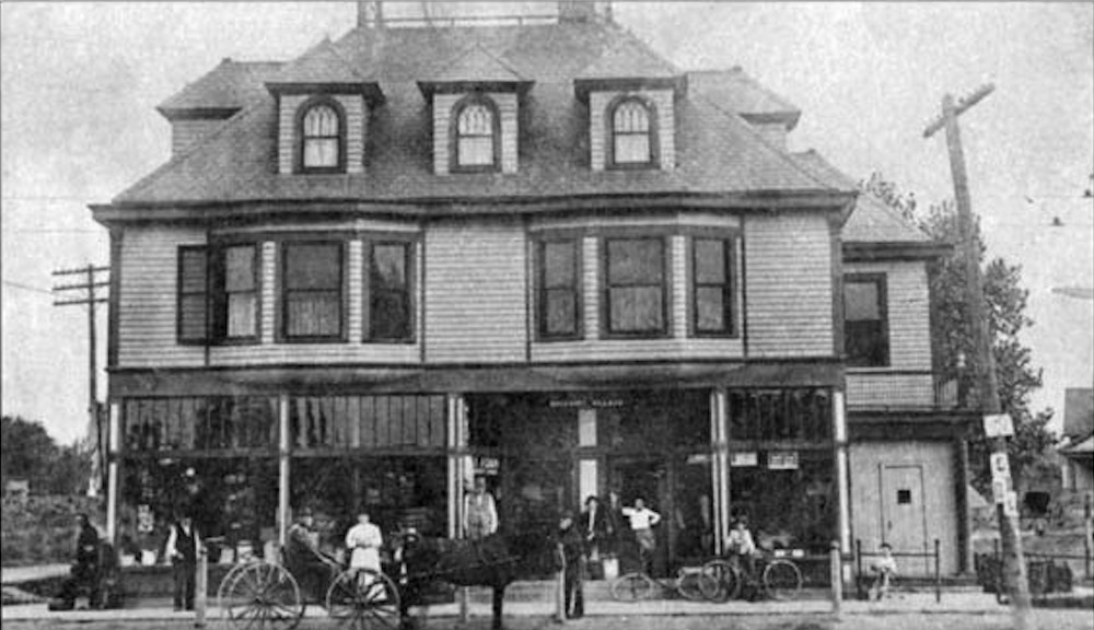
    <summary type="html"><![CDATA[<p><strong><em>Oswald Kamm ran a popular grocery store and post office, at the main intersection of what is today known as “Kamm’s Corners.” He was an influential and popular figure in the early history of West Park, with a lasting legacy that has carried his namesake throughout generations, though few know his entire story. </em></strong></p><img src="https://mail.clevelandhistorical.org/files/fullsize/fac12f260fb02ae7f82d42e2396973be.jpg" alt="Front View of Kamm&#039;s Post Office/General Store" /><br/><p>Standing at the southwest corner of Rocky River Drive and Lorain Avenue (previously Lorain Street), the Kamm Building has been the centerpiece of Kamm's Corners for more than a century. Originally built in 1898-1900 for Oswald Kamm’s general store and later used as a post office, it has been home to many businesses, mostly restaurants, during its time. Its recognition is important, as Kamm served as a popular town figure and played a role in the development of the Kamm’s Corners neighborhood in West Park.</p><p>Oswald Kamm was born in Elm, Switzerland, in 1845. He came to the United States as a young man, and in 1874 he settled on buying a four-acre property at the corner of Lorain Street and Rocky River Drive (formerly Riverside). In the previous year, Kamm had married Anna "Lena" Klaue, who was a member of the local Colbrunn family (her mother was a Colbrunn) who were prominent landowners in Rockport Township. The Colbrunns may have sold Kamm the four-acre property, as they are listed as the owners in 1858. At this corner, Kamm set up a grocery store. (He had previously been a grocery clerk in the Duck Island area of Cleveland.) </p><p>Kamm's original building, a modest one-story structure, faced Rocky River Drive instead of Lorain, as it was the more heavily traveled street at the time. In 1886, Kamm was approached by township officials to become an official post clerk during President Grover Cleveland’s administration. This new venture required Kamm to wake up at four or five every morning and make his way to the Nickel Plate Road rail station (in present-day Rocky River) to pick up the mail and return to his store by six A.M. This eventually led to the coincidental naming of “Kamm's Corners,” which has since become one of four neighborhoods within West Park. Numerous old plat maps refer to the southwest corner of Rocky River Drive and Lorain Street as “Kamm’s Ohio”, and it was written on any mail expected to go to Kamm’s post office. </p><p>The area Oswald Kamm would call home for nearly four decades changed rapidly during their time. When Kamm had arrived at what would have been considered part of “Rockport Township,” it was little more than farmland and a few stately homes. As Lakewood, Rocky River, and Goldwood (Fairview Park) split from Rockport Township and formed as townships, villages, and eventually cities, West Park also became an independent village of about 12.5 square miles. There were several name changes to the area during Kamm’s life: Rockport Hamlet, West Park Township, the Village of West Park, and eventually the city of West Park in 1921. </p><p>In the late 1890s, when Rockport gained rail service, Kamm’s post office became an interurban stop of the Cleveland, Southwestern, and Columbus Railway Co. (CS&C), which was “the second largest operator of interurban railways in Ohio at the time.” In the early 20th century, streetcars and rail lines were a main source of public transportation. Kamm’s stop linked to nearby Puritas Springs Park and ran south toward Berea. CS&C eventually discontinued operations in 1931 due to stock market failure, unprofitable lines, and growing automobile ownership. In 1913, a streetcar known as the “Cleveland Green Line” ran west on Lorain Avenue from Public Square and stopped at Kamm’s Corners. These rail lines shaped the early development of the West Park area. By the 1920s, subdivisions and commercial development had significantly increased in West Park. Kamm’s stop played a major role in the commercialization of Kamm’s Corners. He was a well-known businessman and postal clerk amongst community members and farmers from surrounding areas. Despite Kamm’s role, little was written about him while he was alive.</p><p>In 1909, Kamm constructed a rowhouse-style apartment building known as “Kamm’s Terrace” at 3890 Rocky River Drive, which still exists as an office building. By 1918, a three-story home to the west of his store was built on Lorain Street. Kamm’s house was moved in 1925 to 17134 Fernshaw Avenue, directly behind where it stood before. It stands today as a private residence. Kamm’s daughter Lena and her husband Fred A. Colbrunn, great-grandson of the largest landowning family in the village, lived in a smaller home directly to the north of Kamm’s Terrace, and the couple owned the apartment building until the 1950s. The Colbrunn family owned the Rockport Racing Track at the northeast corner of Lorain and Rocky River Drive and were local contractors and businessmen. The Kamm and Colbrunn families were close in business, and it is possible they assisted Kamm in the construction of his buildings. Both families were involved in the Lorain Greenhouse Co., one of many greenhouses at the time in the former Rockport area. Despite this connection, it appears there is no known architect for any of Kamm’s buildings.</p><p>Oswald and Lena Kamm raised their family in West Park, and had five children: Jacob, Fred, Oswald Jr., Lena, and Dora (who passed away at a young age). When Kamm's wife Lena died in 1917, the village of West Park had a variety of businesses and around 5,000 residents. One year later, Oswald’s eldest son Jacob (born in 1874) died from a murder-suicide, committed by an uncle after a dispute. The crime occurred at a home owned by the uncle further north on Rocky River Drive. Kamm himself died on November 17, 1922, ten days after the city of West Park voted yes on a proposition to be annexed into the city of Cleveland. Overwhelmingly, “The residents of West Park had chosen to become Clevelanders, largely due to promises of five-cent fares and extended streetcar services.”</p><p>After Oswald Kamm’s death, his surviving daughter Lena and various relatives, including members of the Colbrunn family, divided the properties that Kamm had owned. Kamm’s store was converted to a lunch hall and candy store referred to as “Rockport Kelly’s.” A son of a local politician is said to have run the shop. From about 1940 to 1947, it housed Benders Cafe, a dance hall owned by John Bender. In 1944, a rear addition was constructed to allow for a small kitchen. </p><p>After Bender's, the building became perhaps what most West Parkers remember best: Tony’s Spaghetti House, later Tony’s Restaurant under different ownership. The original owners of Tony's were members of the local Zappone family, well-known by locals for their other nearby restaurants, including Mr. Z's and Tony's Diner. Under a second owner, Tony's expanded in 1975 with a rear addition (replacing the previous kitchen) to create a second bar and more dining space. Another addition followed in 1980, this time to expand the kitchen to be fully on the first floor. In the original building, this had been an enclosed porch with a second-story balcony, but by 1980 it was a courtyard that connected the rear parking lot with Lorain Avenue. Tony's lasted just over 50 years before a fire destroyed the interior of the building in 1997. </p><p>Following the fire, Kamm's Corners Development Corporation (now West Park–Kamm’s Neighborhood Development) teamed up with local developer Jim Carney on a $400,000 renovation. The project made use of the City of Cleveland's Storefront Renovation Program (SRP). An initial design by SRP staff member Tim Barrett proposed relocating the building's entrance to the street corner, keeping in character with its appearance during the Bender Cafe and Tony's days. Ultimately, however, a more symmetrical appearance was adopted, with the building's entry centered on the front facade. </p><p>The original building had not been symmetrical. Its entrance was offset, with two proportional storefront windows to the east and a smaller window to the west. The transoms on the original building were longer, and the bulkheads were lower. Notably, the project team was able to color-match the building for a historically accurate paint scheme. </p><p>After renovation, the building housed Alfonso’s Tuscan Grill for just over ten years before becoming Panini’s Bar and Grill. When Panini’s closed, it sat vacant for around two years. Ironwood Cafe began operating in the building in 2015 and later changed its name to Kamm’s Cafe, honoring the Kamm name once again. However, Kamm’s Cafe closed within a year of the name change. In late 2025, legislation was introduced to nominate the Oswald Kamm building as a designated Cleveland landmark under the Landmarks Commission. Plans to re-establish the building as the heart of the neighborhood are underway at this time.</p><p><em><strong><a href="https://mail.clevelandhistorical.org/items/show/935">For more (including 13 images) view the original article</a></strong></em></p>]]></summary>
    <published>2021-01-10T02:49:30+00:00</published>
    <updated>2026-04-17T19:17:42+00:00</updated>
    <link rel="alternate" type="text/html" href="https://mail.clevelandhistorical.org/items/show/935"/>
    <id>https://mail.clevelandhistorical.org/items/show/935</id>
    <author>
      <name>Nate J. Lull</name>
    </author>
  </entry>
  <entry>
    <title type="html"><![CDATA[Saint Patrick Catholic Church of West Park]]></title>
    <summary type="html"><![CDATA[<img src="https://mail.clevelandhistorical.org/files/fullsize/d30ed5ad2f0068f693b06422491f6d3b.jpg" alt="The Oldest Parish" /><br/><p>Saint Patrick Catholic Church in Cleveland's West Park is one of the oldest parishes in the Cleveland Catholic Diocese. The parish was established in 1848 by Reverend Amadeus Rappe, the first bishop of Cleveland and the founder of St. Vincent Charity Hospital. The original parish included about thirty families, most of whom were of Irish descent but also included some German families. The first church was built in 1854 on the site of what is now the cemetery at the northeast corner of Rocky River Drive and Puritas Avenue. The first mass was celebrated in the current church on Christmas Day 1898. The original portion of the church, which still stands today, was expanded in 1953 to accommodate the growing parish.  </p><p>One of the unique components of the parish property – which includes the church, rectory, community center, gymnasium, and school buildings – is the cemetery. The cemetery, with a total of 211 plots, is the burial site of many early Rockport Township pioneers, the first being buried in 1861. At several times throughout the history of the cemetery, the City of Cleveland and the Cleveland Catholic Diocese have tried to have all or portions of the cemetery relocated. For instance, in 1949 the diocese wanted to move the cemetery to its own section of the new Holy Cross Cemetery on Brookpark Road, but parishioners insisted it stay on church grounds. Fortunately, this urban cemetery remains intact to this day.  </p><p>Throughout the years St. Patrick Church, which ultimately grew to over 1,100 families, served not only its parishioners, but also the entire West Park community. Outreach included sports programs open to all, fundraisers for police and fire fighter funds, and a space for Alcoholics Anonymous and other community meetings. The church also operated a hunger center for over 30 years which fed about 130 families a month and more around holidays.  </p><p>In May 2009, St. Patrick Church was ordered to close by Bishop Richard Lennon, and the parish was to merge with those of Ascension and Annunciation as part of the Cleveland Catholic Diocese downsizing. After several unsuccessful appeals to the diocese and the Vatican, the church ultimately closed. But, in the summer of 2011, hope for the future of the church was revived when the Vatican panel considering appeals – and investigating the conduct of the Cleveland Diocese – extended St. Patrick's appeal to March 2012. This final appeal was a success. St. Patrick once again opened their doors to the West Park community in July of 2012. </p><p><em><strong><a href="https://mail.clevelandhistorical.org/items/show/375">For more (including 6 images) view the original article</a></strong></em></p>]]></summary>
    <published>2011-12-21T21:05:54+00:00</published>
    <updated>2026-04-17T19:17:38+00:00</updated>
    <link rel="alternate" type="text/html" href="https://mail.clevelandhistorical.org/items/show/375"/>
    <id>https://mail.clevelandhistorical.org/items/show/375</id>
    <author>
      <name>Tim Knapp</name>
    </author>
  </entry>
</feed>
