<?xml version="1.0" encoding="UTF-8"?>
<feed xmlns="http://www.w3.org/2005/Atom">
  <title type="text">Cleveland Historical</title>
  <updated>2026-08-21T21:05:46+00:00</updated>
  <generator uri="http://framework.zend.com" version="1.12.20">Zend_Feed_Writer</generator>
  <link rel="alternate" type="text/html" href="https://mail.clevelandhistorical.org/"/>
  <link rel="self" type="application/atom+xml" href="https://mail.clevelandhistorical.org/items/browse?output=rss2"/>
  <id>https://mail.clevelandhistorical.org/</id>
  <author>
    <name>Cleveland Historical</name>
    <uri>https://mail.clevelandhistorical.org</uri>
  </author>
  <link rel="hub" href="http://pubsubhubbub.appspot.com/"/>
  <entry>
    <title type="html"><![CDATA[Landmark Office Towers: The Professional and Corporate Heart of the Terminal Group]]></title>
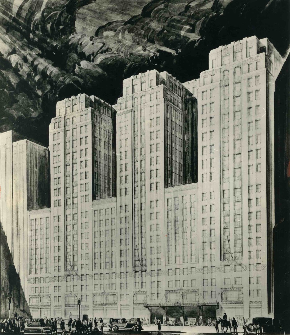
    <summary type="html"><![CDATA[<p><strong><em>Tower City Center, with its Public Square entrance, iconic tower, and flanking hotel and casino, has long overshadowed the office buildings to its rear despite their shared lineage as heirs of the Van Sweringen brothers’ vision. Yet the Landmark Office Towers complex on West Prospect Avenue deserves more attention for its splendid architectural details, novel interior features, and place in the history of some of Cleveland’s most significant corporate giants. </em></strong></p><img src="https://mail.clevelandhistorical.org/files/fullsize/cf17bb9783a0e01e8bcbc10cdc20b577.jpg" alt="Original Rendering of Builders Exchange Building" /><br/><p>The three adjoining buildings that comprise Landmark Office Towers were originally conceived as part of Oris P. and Mantis J. Van Sweringen’s Cleveland Union Terminal complex, the “city within a city” the brothers launched in the 1920s. Designed by Graham, Anderson, Probst & White of Chicago and built between 1929 and 1930, the buildings occupied an entire city block bounded by Prospect Avenue, Huron Road, Ontario Street, and West 2nd Street, all of which were built as viaducts above the railroad tracks entering the Union Terminal. </p><p>In keeping with the idea of a city within a city, each building focused on a different sector: the Medical Arts Building was built for physicians’ and dentists’ offices; the Builders Exchange Building was devoted to businesses associated with the building trades; and the Midland Bank Building was dedicated to banking institutions and other business firms. The buildings included passageways connecting them with each other and with other components of the Terminal complex. A skybridge over Prospect, planned to link the Medical Arts Building with Higbee’s department store, was never added. </p><p>The three buildings were all built with structural steel frames clad with gray limestone on the lower four floors, cream face brick above, and terra-cotta trim near the tops. Detailed Art Deco motifs graced each facade, and the complex featured setbacks and light wells to break their bulk and provide ventilation. Inside, they featured travertine marble floors, fluted pilasters, plaster ceilings with ornamental friezes, and bronze elevator doors. The three-story lobby of the Midland Bank Building featured a wood-burning fireplace, a mezzanine, and pillars and panels carved from the trunks of seven giant oak trees. The trees were selected from an English estate and transported by steamship from Liverpool. The Builders Exchange Building included Guildhall, a tenth-floor restaurant inspired by a 15th-century London namesake, and a two-story demonstration house called the <a href="https://clevelandhistorical.org/admin/items/show/1028">Home in the Sky</a> on its two top levels.</p><p>The introduction of such an expansive block of choice office space soon after the onset of the Great Depression had a profound impact on downtown, precipitating a consolidation of business and professional activity around the Terminal and leaving older office buildings with hard-to-fill vacancies. Four major corporate headquarters relocated to the complex between 1930 and 1935. Two were local: Sherwin-Williams moved its offices from its Canal Road property into portions of the Midland Building and Builders Exchange Building, while Standard Oil Co. of Ohio (Sohio) left the East Ohio Gas Building on East 6th for the Midland Building. The Midland Building also attracted the Erie Railroad headquarters away from New York City in 1931 and Republic Steel from Youngstown in 1935. The arrival of the latter led the Medical Arts Building to be renamed the Republic Building. </p><p>Yet the Depression also forced the complex to grapple with challenges. In 1932, Midland Bank went bankrupt and merged into Cleveland Trust, closing its offices in its namesake building. Three years later, the Van Sweringen Company went bankrupt. Thereafter, ownership of the towers complex was administered by the Prospect Terminals Building Co., a subsidiary of Cleveland Terminal Building Co. In 1940, the Cleveland Builders Exchange left for a new headquarters on Euclid Avenue, and Sherwin-Williams expanded to the floors that had housed the Exchange's Home in the Sky. At that time, the building was named the Guildhall Building.</p><p>In 1950, Cleveland Terminal Building Co. sold the entirety of the Union Terminal group except the rail station in 1950 to the 66 Trust of Philadelphia. That same year, the four main tenants of the towers complex — Republic Steel, Erie Railroad, Sohio, and Sherwin-Williams — formed RESS Realty (a portmanteau of their names) to coordinate leasing of office space in the three conjoined towers. For the 35 years that followed, the complex harbored a workforce of around 5,000 people. </p><p>In 1986, ten years after the Erie-Lackawanna Railroad (formerly Erie Railroad) closed its Cleveland headquarters following its merger into Philadelphia-based Conrail, Sohio completed its move from the Midland Building to its new 45-story headquarters on Public Square. Following the departures of these firms and Republic’s recent merger into LTV Steel, RESS Realty was administered by only LTV and Sherwin-Williams. In the year preceding Sohio’s exit, RESS Realty renovated and rebranded the LTV-Guildhall-Midland Building complex as Landmark Office Towers. </p><p>During the renovations, Sherwin-Williams bought the complex, bringing its ownership back to Cleveland. Changes included a central lobby for the elevator banks serving all three buildings, along with the revitalization of the Midland Building’s lobby, which Sohio had modernized into offices with dropped ceilings in 1970, as the Van Sweringen Arcade. The bank’s vault became Haymarket Restaurant, later Piperade, and then Hyde Park Chophouse until the space closed in 2011. </p><p>The renovation and promotion succeeded in turning around the towers at a critical time. After Sohio moved out, the complex’s occupancy dropped from 100% to 62%, but upon completion of the renovations, it bounced back to 90%. Landmark Office Towers had a nearly four-decade run until its owner, Sherwin-Williams, sold the complex to Detroit-based Bedrock in 2023 ahead of the paint and coatings company’s move to its new 36-story headquarters tower on Public Square. Today, the future of the complex seems tied to Bedrock’s Riverfront Cleveland project, but its precise use is uncertain. Office demand in downtown districts has not recovered from the pandemic collapse of 2020, and conversion of such a massive structure to residential use is costly. But the towers — with their Art Deco flourishes, contribution to a big-city atmosphere, and central location in an evolving downtown — deserve a new, bold vision.</p><p><em><strong><a href="https://mail.clevelandhistorical.org/items/show/1084">For more (including 21 images) view the original article</a></strong></em></p>]]></summary>
    <published>2026-04-03T13:57:15+00:00</published>
    <updated>2026-07-29T17:40:46+00:00</updated>
    <link rel="alternate" type="text/html" href="https://mail.clevelandhistorical.org/items/show/1084"/>
    <id>https://mail.clevelandhistorical.org/items/show/1084</id>
    <author>
      <name>J. Mark Souther</name>
    </author>
  </entry>
  <entry>
    <title type="html"><![CDATA[Cleveland and Youngstown Railroad: Constructing a Long, Gradual Grade Down from the Heights]]></title>
    <summary type="html"><![CDATA[<img src="https://mail.clevelandhistorical.org/files/fullsize/510a3a0e4dfc6148d9a7590675879be2.jpg" alt="Cutting the Trench, 1915" /><br/><p>The settlement of the Heights on Cleveland's east side was dependent upon electric streetcars with sufficient power to ascend the Portage Escarpment at Cedar Glen in the 1890s. From there, streetcars opened heights land for development progressively farther east until the Van Sweringen brothers faced the task of making their distant Shaker Heights project accessible to downtown. The Vans created the Cleveland & Youngstown Railroad to make this connection, envisioning an interurban train linking Cleveland to the growing east side, and specifically their Shaker Village development (later Shaker Heights). The C&Y became their means of performing a number of transportation projects, building freight yards for other railroads and, here, putting in place the infrastructure necessary to bring the Shaker Rapid down off the Heights.</p><p>Trains, including the Rapid, require gentle grades in order to be operated economically. Too steep a slope and additional engines have to be added, or less weight can be hauled up hill, or both. To traverse the eighty feet of elevation between Shaker Square and the base of the Escarpment cliff west of Woodhill Road, a long elevated roadbed was required, including several bridges to allow north-south traffic to cross below the tracks. This roadbed is a little over a mile in length, meaning the resulting 1.25 percent grade could permit the Rapid to run affordably between Shaker Heights and downtown Cleveland. </p><p>The grading of the Rapid's right-of-way actually starts at Shaker Square, as the roadbed gradually descends into a trench between the two lanes of Shaker Boulevard, eventually becoming deep enough to pass underneath Woodhill Road. From that point west the tracks emerge onto an elevated bed that gradually descends to the level of the city. In doing so, it crosses over nine streets and two sets of railroad tracks, each of which has a bridge carrying the Rapid overhead. The bridge at Holton Avenue is one of Cleveland's most interesting and unappreciated structures.  </p><p>This roadbed was created by building a temporary trestle of logs to get the tracks sufficiently elevated. Then trains of hopper cars were brought in on these tracks to dump large quantities of dirt and stone ballast to fill in the trestle. This was more economical than trying to pile up the ballast from below and then place tracks on top later.</p><p>At first the Rapid reached the bottom of the roadbed and moved onto tracks in the city's streets to finish the journey to Public Square, but that was only a temporary expediency. The ultimate goal was to bring the Rapid into the lower level of the Van Sweringens' new Cleveland Union Terminal passenger station beneath their Terminal Tower complex. To do this, the trains needed to come into town near the level of the river, where the major railroad passenger trains would also be delivering passengers to the C.U.T. This entailed extending the Rapid's grade dozens of feet lower, which they did through the gradual descent of Kingsbury Run, a tributary of the Cuyahoga River. It was the need to secure rights to use existing tracks of the Nickel Plate Road that led to the Vans purchasing the Nickel Plate Railroad and becoming a major player in North American railroading in the 1930s.  </p><p>But the original focus of their attention was developing Shaker Heights up on the Portage Escarpment and making it possible to move their homeowners quickly to their jobs in downtown Cleveland. This led to their building the Cleveland & Youngstown's elevated roadbed that is largely unseen by the multitude of people who still ride the RTA's Green and Blue Lines west of Shaker Square, but deserves to be recognized as an important piece of Cleveland's urban infrastructure.</p><p><em><strong><a href="https://mail.clevelandhistorical.org/items/show/658">For more (including 9 images) view the original article</a></strong></em></p>]]></summary>
    <published>2014-05-16T16:22:18+00:00</published>
    <updated>2026-04-17T19:17:40+00:00</updated>
    <link rel="alternate" type="text/html" href="https://mail.clevelandhistorical.org/items/show/658"/>
    <id>https://mail.clevelandhistorical.org/items/show/658</id>
    <author>
      <name>William C. Barrow</name>
    </author>
  </entry>
  <entry>
    <title type="html"><![CDATA[Smead Rolling Road]]></title>
    <summary type="html"><![CDATA[<img src="https://mail.clevelandhistorical.org/files/fullsize/347a9d5073c37f483b020a09c4b0567d.jpg" alt="The Rolling Road" /><br/><p>The Smead Rolling Road was a mechanical device built into the roadbed of Eagle Avenue to help haul wagons to the top of the cliffs framing the Cuyahoga Valley in the days before sufficiently powerful trucks were developed.  Vaguely reminiscent of the mechanics behind San Francisco's cable cars, this contraption lasted a brief time before being abandoned and later demolished when the tracks for the Cleveland Union Terminal were installed across Eagle Avenue's route. </p><p>Cleveland was founded in 1796 at the mouth of the Cuyahoga with Lake Erie to take advantage of the portage between the Great Lakes system and the Ohio and Mississippi rivers to New Orleans.  This portage, where Akron is today, was a short land route for carrying boats that linked these water systems via the Cuyahoga River and promised a strong economic future for the young village.  </p><p>In the early nineteenth century, the potential of the portage route was realized by the construction of the Ohio & Erie Canal, which accelerated Cleveland's rise as an important western commercial city.  The canal entered the city alongside the river and ended near its mouth at Lake Erie, ensuring that all the heavy cargo coming to Cleveland via the canal, river and lake would arrive down at the water level, eighty feet below the city. Railroads, which tended to employ the long grades of the Cuyahoga's tributary streams to enter the valley and its docks, further concentrated the arrival of heavy freight below where the population lived, worked, and shopped.</p><p>Before trucks came to have sufficient power to traverse the steep grades of the river banks, it was difficult for horse-powered wagons to supply produce to the city.  To address this problem, in 1906 inventor Isaac D. Smead patented his "rolling road," a electric-powered device to pull unharnessed wagons up Eagle Avenue from the Flats to Ontario Street, right at the popular Central Market.  </p><p>In the nineteenth century, "Colonel" Smead had been a major figure in the heating and ventilating business, at one point reputed to be the leading manufacturer of such equipment for public buildings in America.  The Panic of 1893 led to his bankruptcy and he turned to other engineering pursuits. He designed the rolling road as an electric-powered moving belt, to which wagons could be attached. The wagon's team of horses would be unharnessed and walked uphill while the wagon made the trip up the rolling road at three to six miles per hour.  The former process of moving wagons up by horsepower alone was said to take twenty minutes to an hour, while Smead's invention cut it to two minutes.</p><p>While it appears to have operated satisfactorily, it wasn't long before improvements in internal combustion engines powered trucks sufficiently to render it obsolete, when it was abandoned and its remnants dominating the center of Eagle Avenue for years. Writing in his memoirs, The Ginney Block, Edward D'Alessandro told a tragic story about his youth and the remains of the rolling road. A gang of his friends and he were racing on sleds down Eagle Avenue.  The youth in the lead slid out into the intersection with Canal Road and was killed by a passing truck.  D'Alessandro, who would later go on to lead the Cleveland Public Library system, was able to swerve his sled into the rolling road's foundations and escape a similar fate.</p><p>In the 1920s the Terminal Tower complex on Public Square was being built and its Cleveland Union Terminal passenger station in the lower sections was designed to bring trains through the valley.  This wiped out Eagle Avenue, which henceforth traversed a bridge over the tracks.  That bridge lasted into the 21st century, when much of it in turn was demolished and thus Eagle Avenue no longer connects Ontario Street with the Flats.  But for decades, between the Smead Rolling Road and the subsequent bridge, Eagle Avenue was one of the city's more engineered roads.</p><p><em><strong><a href="https://mail.clevelandhistorical.org/items/show/656">For more (including 6 images) view the original article</a></strong></em></p>]]></summary>
    <published>2014-05-12T10:52:23+00:00</published>
    <updated>2026-04-17T19:17:40+00:00</updated>
    <link rel="alternate" type="text/html" href="https://mail.clevelandhistorical.org/items/show/656"/>
    <id>https://mail.clevelandhistorical.org/items/show/656</id>
    <author>
      <name>William C. Barrow</name>
    </author>
  </entry>
  <entry>
    <title type="html"><![CDATA[Cedar Glen]]></title>
    <summary type="html"><![CDATA[<img src="https://mail.clevelandhistorical.org/files/fullsize/673888f5fa758b81544c09e6e2cb3160.jpg" alt="Cedar Glen at Ambleside, 1930" /><br/><p>Until the late 1800s, looking down from atop Cedar Hill you would have seen little more than a countryside landscape divided by an unkempt dirt road. The hillside known as Cedar Glen hosted few travellers aside from farm wagons and, later, visitors to the springs resort at the foot of the hill. In less than a century, this scene would be replaced by one of a busy, six-lane road as Cedar Glen became the biggest gateway to the Heights from the city of Cleveland. </p><p>One of Cedar Glen's most salient characteristics is its gradual rise in elevation. The western edge of the Portage Escarpment causes this natural formation. The Portage Escarpment not only divides the Allegheny Plateau and the Great Lakes Basin, but also acts as a boundary between Cleveland and its suburban "Heights" to the east. Originally the eastern part of Cedar Glen and the high ground to which it leads belonged to East Cleveland Township. When Cleveland Heights incorporated as a village in 1903, it engulfed the southern part of East Cleveland Township, which included farmland and Cedar Glen. </p><p>Another natural feature that, for a time, made Cedar Glen a well-known area was Doan Brook, which was piped and buried underground in 1929. In the early 1800s, bluish grey sandstone called Euclid bluestone was quarried along the brook. The hard sandstone was used for everything from laundry tubs to sidewalks. Later in the century Doan Brook again brought attention to Cedar Glen. Dr. Nathan Hardy Ambler was a former dentist and the owner of the Cedar Glen property through which Doan Brook passes on its way from Shaker Lakes to Lake Erie. Although the blue-green water tasted like sulfur, Ambler began bottling and selling it to local restaurants. Because patrons believed the water offered health benefits and hydrotherapy was becoming a popular treatment method, Ambler and his partner Daniel O. Caswell opened the Blue Rock Spring House in Cedar Glen. The water resort and sanitarium operated from 1880 until 1908 when popularity began to fade. </p><p>Cedar Glen began its transition to one of Cleveland's most important transportation gateways from the suburbs in 1896 when entrepreneur and suburban developer Patrick Calhoun donated a large tract of land to the city's park system. One of the conditions of the gift was that Calhoun would be permitted to run a double-line street railway through Cedar Glen. Construction began that fall on the street railway that was intended to bring passengers to and from Euclid Heights and Ambler Heights, prestigious residential allotments on the "Overlook." The increase in suburban residents and visitors made possible the construction of the <a href="https://clevelandhistorical.org/items/show/198">Cedar Fairmount</a> retail district at the top of the hill. </p><p>By the 1920s Cedar Glen was bustling with heavy streetcar and automobile traffic. At the end of that decade a tunnel and platform were built on the western end of Cedar Glen in conjunction with the construction of the Cleveland Union Terminal, further connecting Cleveland Heights to its urban neighbor. In the mid 1950s Cleveland Transit Service (CTS), the predecessor of today's RTA, built the University Circle Rapid Transit Station at the same location on the bottom of Cedar Glen where the tunnel was constructed twenty-five years earlier. Completely transformed from its onetime status as a barren, dirt road, Cedar Glen now remains a well-traveled gateway to and from Cleveland.</p><p><em><strong><a href="https://mail.clevelandhistorical.org/items/show/547">For more (including 13 images&#32;&amp;&#32;1 audio file) view the original article</a></strong></em></p>]]></summary>
    <published>2012-08-30T21:06:26+00:00</published>
    <updated>2026-04-17T19:17:39+00:00</updated>
    <link rel="alternate" type="text/html" href="https://mail.clevelandhistorical.org/items/show/547"/>
    <id>https://mail.clevelandhistorical.org/items/show/547</id>
    <author>
      <name>Heidi Fearing</name>
    </author>
  </entry>
  <entry>
    <title type="html"><![CDATA[The Van Sweringen Railroad Empire]]></title>
    <summary type="html"><![CDATA[<img src="https://mail.clevelandhistorical.org/files/fullsize/8b66b84e084d843a592f89630c226e8b.jpg" alt="Passenger Train Leaving Terminal" /><br/><p>The path followed by the Van Sweringen brothers in developing a rapid transit system led to the creation of a vast railroad empire. While their foray into the railroad business may have begun half-hazard, it was a natural extension of their interests and efforts in securing the right of way between Shaker Village and Cleveland. </p><p>The beginnings of the Van Sweringen railroad empire grew from the brothers' attempts to extend a street car line to their residential community during the first decade of the 20th century.  Having approached the Cleveland Railroad Co., which held the city's streetcar franchise, the brothers were refused on the grounds that there was not a sufficient population to service. The brothers soon began the process of acquiring land to build a direct line from Shaker Village to Cleveland's downtown. In 1909, they acquired a four-acre lot to act as a downtown terminal and organized the Cleveland and Youngstown Railroad for the operation of an electric train line. To complete this plan, however, the Cleveland and Youngstown Railroad would need to cross existing tracks owned by New York Central. The president of New York Central, Alfred H. Smith, had grown up in Cleveland and was known by the Van Sweringen brothers. New York Central was interested in both a new freight station and route into the ever-expanding Midwestern city, and deals were made. Working with, and predominantly funded by New York Central, the Van Sweringen brothers headed construction of the project. When completed, half the right of way and the station were deeded to New York Central. Passenger-only tracks running along the line became known as the Cleveland Interurban Railroad.</p><p>New York Central also owned the Nickel Plate Railroad, which followed a similar route from 34th Street to downtown as the line envisioned by the Van Sweringens. While the brothers had originally approached New York Central to negotiate use of the tracks, the railroad empire was under scrutiny from the Federal Government for owning railroad lines that theoretically should have been competing. Understanding that they would eventually be required to dispose of the the Nickel Plate line, New York Central sold the 513 miles of railroad to the Van Sweringens in 1916. While newspaper accounts suggested the railway's worth to be valued at both $30,000,000 in stocks and bonds, the control of the Nickel Plate was transferred to the brothers for $8,500,000. Two million was borrowed from banks and paid immediately, while the remaining was to be paid in installments of $650,000. This sale enabled New York Central to dispose of the railroad without selling to one of their competitors. It was also to be the first step in the creation of the Van Sweringen railroad empire. </p><p>Following the Van Sweringens' purchase of the Nickel Plate Railway from New York Central, John J. Bennett was brought in as president of the line. Under his leadership, the railroad business became increasingly profitable for the brothers. They continued to acquire railroad companies over the following 14 years, and, by 1929, had developed an empire worth three billion dollars. </p><p>As with their real estate and rapid transit investments, the Great Depression brought an end to the brothers' success. Following the death of Mantis in 1935 and Oris the following year, the Van Sweringen railroad company was declared bankrupt and sold at public auction in 1938.</p><p><em><strong><a href="https://mail.clevelandhistorical.org/items/show/414">For more (including 11 images) view the original article</a></strong></em></p>]]></summary>
    <published>2012-03-01T01:14:08+00:00</published>
    <updated>2026-04-17T19:17:38+00:00</updated>
    <link rel="alternate" type="text/html" href="https://mail.clevelandhistorical.org/items/show/414"/>
    <id>https://mail.clevelandhistorical.org/items/show/414</id>
    <author>
      <name>Richard Raponi</name>
    </author>
  </entry>
  <entry>
    <title type="html"><![CDATA[Lynnfield Road Rapid Transit Station: Onetime Terminus of the Van Aken Line]]></title>
    <summary type="html"><![CDATA[<img src="https://mail.clevelandhistorical.org/files/fullsize/b9dc447fb4f31958806e8c7b46bb3bc6.jpg" alt="Lynnfield Station" /><br/><p>Opened on April 11, 1920, the Lynnfield passenger station was constructed as the final stop along the South Moreland (now Van Aken) line of the Cleveland Interurban Railroad in Shaker Village. Besides a few homes located in the vicinity along Kinsman Road and Center Road, the area was completely undeveloped. The construction of this small station in the middle of nowhere was the culmination of years of planning, land acquisition, and construction headed by Oris Paxton and Mantis James Van Sweringen to build the Cleveland Interurban Railroad — a rapid transit system that laid at the heart of their plans for the development of Shaker Village.</p><p>From the time of their initial speculation and investment in the Shaker area in 1908, the Van Sweringen brothers understood the importance of efficient and timely transportation between Cleveland and their desired upper-class enclave. Elite suburbs connected to metropolitan areas by railway were gaining popularity with people of means throughout the United States as cities grew increasingly industrialized and congested. Cleveland Heights, as well as suburbs outside of Cincinnati, Chicago, and New York City, offered examples of these successful real estate ventures. Initially, the Van Sweringens planned to extend a streetcar line to their residential community. Refused by the operators of Cleveland's streetcar franchise, the Vans began acquiring land and the right of way to provide an electric train line to the city's downtown from their suburb.</p><p>During the timely process of preparing for the transit system, the Van Sweringens negotiated an interim solution for Shaker Village's lack of public transportation with the Cleveland Railroad Co. and Cleveland Heights. The Cleveland Interurban Railroad would lay tracks for a streetcar to connect Shaker Village with Cleveland Heights, which had a line running into the City of Cleveland. Opened in 1907, this <a href="https://clevelandhistorical.org/items/show/418">Shaker Lakes Line</a> provided access to and from the Shaker area. A trip to the city, however, would still take over an hour.</p><p>By 1916, the brothers had acquired the right of way from Shaker Village to Cleveland and construction for the Cleveland Interurban Railroad began. Delayed by World War I, the transit system would not be completed for six years. Upon its opening, transportation time from the suburb to the urban center was cut by more than half. From Moreland Circle, later known as Shaker Square, the estimated travel time to the downtown was 20 minutes. From the Lynnfield Station, the trip would take a half hour. The impact of the electric train on Shaker Village was profound and immediate. Between 1919 and 1929, the population of Shaker Heights grew from 1,700 to 15,500, property value increased from less than a million dollars to over $80 million, and nearly 3,000 new homes were constructed. The success of this rapid transit system in promoting the development of Shaker Heights would also spur the construction of Cleveland's most defining building, the Terminal Tower.</p><p>While the area surrounding the Lynnfield Station would not see residential growth for well over a decade after its construction, the small passenger station at what is now 18900 Van Aken Boulevard reflects the foresight and planning of the Van Sweringen brothers in the development of one of America's most prominent and successful rail suburbs. The structure was designated a Shaker Heights Landmark on June 22, 1998.</p><p><em><strong><a href="https://mail.clevelandhistorical.org/items/show/412">For more (including 11 images) view the original article</a></strong></em></p>]]></summary>
    <published>2012-02-29T09:53:42+00:00</published>
    <updated>2026-04-17T19:17:38+00:00</updated>
    <link rel="alternate" type="text/html" href="https://mail.clevelandhistorical.org/items/show/412"/>
    <id>https://mail.clevelandhistorical.org/items/show/412</id>
    <author>
      <name>Richard Raponi</name>
    </author>
  </entry>
  <entry>
    <title type="html"><![CDATA[The Van Sweringen Brothers: Cleveland&#039;s Visionary Developers]]></title>
    <summary type="html"><![CDATA[<img src="https://mail.clevelandhistorical.org/files/fullsize/0bc0fb99ae7d596b3c71cca9c19c7acd.jpg" alt="Van Sweringen Bros., 1928" /><br/><p>Oris and Mantis Van Sweringen, the brothers responsible for the construction of both the Union Terminal Complex and the Village of Shaker Heights, are two of the least remembered contributors to the development of Cleveland and its suburbs. The shy, reclusive Van Sweringens — absent even from the Terminal Tower's grand opening ceremonies in 1930 — worked their way up from modest beginnings to amass a multi-billion-dollar railroad and real estate empire by the 1920s. Their Union Terminal project helped to revitalize Downtown Cleveland's traditional center, Public Square, while their Shaker Heights development proved to be enormously attractive to wealthy city residents and remains a viable community to this day.</p><p>The development of Shaker Heights began around 1905 when "the Vans" began planning a picturesque community where both the design of the houses and the type of people allowed in would be strictly controlled. These restrictions were put in place in order to maintain Shaker's spatial and social distinctiveness from the increasingly polluted and overcrowded nature of big-city life in Cleveland.</p><p>The Terminal Tower complex grew out of the brothers' efforts to provide a system of rapid transit from Shaker to Downtown Cleveland for suburban commuters. Their original plan for a small terminal near Public Square morphed into the massive Cleveland Union Terminal project, which included a new central rail station for the city in addition to the 52-story Terminal Tower and three other office buildings. </p><p>The brothers died relatively young — and only a year apart from one another — in the mid 1930s.  Much of their fortune had dwindled away with the onset of the Great Depression and the unraveling of their complicated series of holding companies. Many younger Clevelanders are likely unfamiliar with the story of the Van Sweringens, and one would be hard pressed to find a building or street in the area bearing their name. Their success at avoiding the spotlight has endured, leaving their contributions to Cleveland's history largely obscured. </p><p><em><strong><a href="https://mail.clevelandhistorical.org/items/show/66">For more (including 6 images, 1 audio file,&#32;&amp;&#32;2 videos) view the original article</a></strong></em></p>]]></summary>
    <published>2010-09-22T14:38:06+00:00</published>
    <updated>2026-04-20T22:49:46+00:00</updated>
    <link rel="alternate" type="text/html" href="https://mail.clevelandhistorical.org/items/show/66"/>
    <id>https://mail.clevelandhistorical.org/items/show/66</id>
    <author>
      <name>CSU Center for Public History and Digital Humanities</name>
    </author>
  </entry>
  <entry>
    <title type="html"><![CDATA[Public Square: Two Centuries of Transformation]]></title>
    <summary type="html"><![CDATA[<img src="https://mail.clevelandhistorical.org/files/fullsize/1310959b1a93a8e6400ea5b6dfba963f.jpg" alt="Postcard View" /><br/><p>Laid out by Moses Cleaveland's surveying party in 1796 in the tradition of the New England village green, Public Square marked the center of the Connecticut Land Company's plan for Cleveland and, soon, a ceremonial space for the growing city. In 1856, Cleveland's first fountain was constructed on the square. Four years later a statue of Battle of Lake Erie hero Commodore Oliver Hazard Perry was erected in the center of the square, leading City Council to rename Public Square as Monumental Park. In 1865, Clevelanders watched returning Civil War regiments as they mustered on Public Square, and later generations would greet returning veterans from subsequent wars. Public Square also provided a space for viewing the caskets of fallen U.S. Presidents Abraham Lincoln and James A. Garfield in 1865 and 1881, respectively. In perhaps its most notable moment in the 19th century, in 1879, Public Square garnered international attention when inventor Charles F. Brush showcased one of the world's first successful demonstrations of electric streetlights there.</p><p>Adding to the reputation of Monumental Park, a statue of Moses Cleaveland rose on the northwest quadrant in 1888, and on July 4, 1894, the 125-foot-tall <a href="https://clevelandhistorical.org/items/show/332">Soldiers' and Sailors' Monument</a> was dedicated on the square's southeast quadrant in honor of Civil War veterans, at which time Perry's monument was moved, first to Wade Park. Although protests halted an 1895 plan to erect a massive new City Hall across the northern half of Public Square with an arch to permit Ontario Street traffic to pass underneath, in the following year the city marked its centennial with a large arch over Superior Avenue just east of Ontario and a replica of an original log cabin in the northeast quadrant. </p><p>In addition to its symbolic value, Public Square has also been a transit hub since the 19th century, first as a point of arrival for stagecoaches, and later as the hub of streetcar, interurban railway, and bus lines. Traffic patterns around Public Square were a source of much controversy in the 19th century. In the 1850s, supporters of a fully enclosed square erected a fence around its entire perimeter, preventing traffic from entering. Eventually the transit demands of an expanding city won out, and in 1867 roads once again passed through the center of Public Square.  Since that time, Public Square has labored under often-conflicting demands that it serve simultaneously as symbolic space, transit hub, and park. The opening of the Cleveland Union Terminal in 1930 prompted a sprucing up of Public Square, including the removal of a pavilion and a rustic bridge over an artificial stream that had occupied the square's southwest quadrant for decades. In their place was a large open lawn that provided a tidier "front yard" for the tallest building in the world outside New York. In the years that followed, transit use gradually eclipsed whatever parklike qualities the space had held.</p><p>In 1943 a new transit plan called for a new central subway station under Public Square. Ontario Street was to be depressed beneath Superior Avenue, and the Soldiers' and Sailors' Monument was to be relocated elsewhere. A Plain Dealer reporter quipped that the statue's removal "alone is almost worth the cost."  The 1940s and 1950s passed with no action on building a subway system. A 1958 plan proposed by architect Howard B. Cain, whose Park Building offices overlooked Public Square, envisioned closing Ontario, depressing Superior below grade, removing the Soldiers' and Sailors' Monument, and creating a Rockefeller Plaza-influenced sunken plaza with an ice-skating rink. Dubbed International Square, Cain's transformation--no doubt inspired by the expanded world trade that boosters claimed the impending opening of the St. Lawrence Seaway would produce-imagined shops and restaurants representing many nations. The next year, a new downtown master plan revived the idea of a subway under Public Square, this time affecting only its southern half. The plan also called for lowering the level of the northern half of the square, moving the Soldiers' and Sailors' Monument to the northeastern quadrant and building a sunken ice rink in the northwestern quadrant.  Like Cain's plan, this part of the downtown plan languished when county commissioners nixed the subway project. In the wake of the subway defeat, a 1960 plan to close through streets in Public Square and construct a 1,600-car underground garage likewise failed.  </p><p>Yet, the dream of remaking Public Square did not disappear. In the 1970s, urban planner Lawrence Halprin brought his imaginative renewal ideas to Cleveland. Halprin recommended turning Euclid Avenue into a pedestrian mall and remaking Public Square into a more parklike space. Iris Vail, wife of Plain Dealer publisher Thomas Vail, and other Garden Club of Cleveland women held a "Beautification Ball" in the Arcade in 1975 to raise $100,000 to finance a specific blueprint for the square. They hired Don M. Hisaka of Cleveland and Sasaki Associates of Massachusetts to design the new Public Square but then decided they did not like his minimalist, modernistic vision for the space. Instead, they spearheaded a more traditional parklike redo of the northeastern quadrant as a demonstration. Over the ensuing decade, Public Square was remade quadrant by quadrant as city, county, state, and federal funds, along with Cleveland Foundation and Garden Club monies--in all $12 million, augmented the original $100,000 raised by the Garden Club.  </p><p>Opened with laser-show fanfare just in time for Cleveland's sesquicentennial in 1986, the revamped Public Square sported parklike spaces and, in the southwest quadrant, a brick and granite terraced plaza with an artificial waterfall. In maintaining Superior and Ontario as through streets, the 1980s Public Square remake fell well short of decades of visions for reuniting the four isolated quadrants. In 2002 the New York-based Project for Public Spaces visited Cleveland and urged reunification of the square, calling it one of the world's most dysfunctional public spaces. Mayor Frank Jackson's appointed Group Plan Commission, a blue-ribbon committee inspired by Daniel Burnham's famed "Group Plan" of a century before, set out to make both the Mall and Public Square reach their potential as appealing destinations for locals and visitors. The commission approved a plan by James Corner, known for his innovative High Line project, which transformed an abandoned elevated railroad in New York City into a linear park. With the announcement of Cleveland's selection to host the 2016 Republican National Convention, civic leaders rallied to raise the $32 million needed make the long-awaited reunification of Public Square a reality.</p><p><em><strong><a href="https://mail.clevelandhistorical.org/items/show/22">For more (including 17 images&#32;&amp;&#32;3 audio files) view the original article</a></strong></em></p>]]></summary>
    <published>2010-09-16T09:12:46+00:00</published>
    <updated>2026-04-17T19:17:36+00:00</updated>
    <link rel="alternate" type="text/html" href="https://mail.clevelandhistorical.org/items/show/22"/>
    <id>https://mail.clevelandhistorical.org/items/show/22</id>
    <author>
      <name>J. Mark Souther</name>
    </author>
  </entry>
  <entry>
    <title type="html"><![CDATA[Terminal Tower: Cleveland&#039;s Signature Skyscraper]]></title>
    <summary type="html"><![CDATA[<img src="https://mail.clevelandhistorical.org/files/fullsize/1dc25e5ec5be8090d9d137bf06dfe245.jpg" alt="West Approach to Cleveland Union Terminal" /><br/><p>Although today the first sign of downtown that a motorist is sure to spot from any direction is the Key Tower, prior to its completion in the early 1990s the first sight was the Terminal Tower. Despite its eclipse by a later, taller skyscraper, the 52-story, 708-foot-tall Terminal Tower was an instant icon and has arguably remained Cleveland’s most potent symbol. The Terminal Tower, at least as a plan, didn’t start as a tower at all, but instead as a railway station known as the Cleveland Union Terminal. In the early 20th century, as Cleveland grew as an industrial powerhouse, many Northeast Ohioans used railway lines to get to their destinations. Ohio had one of the most extensive interurban networks, with over 2,000 miles of track. However, it was not commuter railways but rather intercity passenger trains that led to the creation of the Terminal. Steam locomotives produced excessive amounts of pollutants when converging downtown, hampering Cleveland’s goal of becoming a modern, attractive city. In the interest of smoke abatement, the Union Terminal project would rely on switching trains to electric engines at outlying rail yards before passing through the city, including its central rail terminal.
The only problem was where to place this symbol of Cleveland’s progress. Inspired by Chicago’s Columbian Exposition of 1893, Cleveland Mayor Tom Johnson and the Group Plan Commission began planning a “civic center” that would run from Superior Avenue all the way to the lakefront. This civic center centered on the <a href="https://clevelandhistorical.org/items/show/312">Mall</a> and was Cleveland’s dominant expression of the City Beautiful. But the plan to make a new railway along the lakefront as the grand point of entry to the city came to a halt because of unexpected developments. Enter the <a href="https://clevelandhistorical.org/items/show/66">Van Sweringen brothers</a>, Mantis J. and Oris P., a duo of real estate and railroad tycoons who were keen on connecting their master-planned suburb of Shaker Heights to downtown via a new rapid transit rail line. </p><p>While the Van Sweringens originally planned the Shaker Heights line, their ambition expanded. The brothers realized that for the station for Public Square to succeed, they needed to include railways and facilities next to it. After heated debates that lasted a few years, the Terminal cornerstone was set on March 16, 1927, tilting downtown Cleveland’s center of gravity decidedly back to Public Square and ending the concept of a Mall anchored by an imposing rail station. The project was estimated at around $170 million and the Union Terminal had its grand opening in 1930. Travelers to Cleveland found many shops and services inside the Terminal’s concourses without having to step outside, including the elegant English Oak Room, Fred Harvey Company concessions, Higbee Bros. department store, and the preexisting adjacent <a href="https://clevelandhistorical.org/items/show/465">Hotel Cleveland</a>. The 42nd floor was used as an observation deck, allowing a bird's-eye view of the city. The Terminal’s concept of a multiuse “city within a city” anticipated New York’s Rockefeller Center. The Van Sweringen brothers, never comfortable in the spotlight, did not attend the 1930 dedication, instead spending the day at Roundwood Manor, their country estate in Hunting Valley. </p><p>The Terminal Tower itself was built toward the end of the skyscraper craze of the 1920s. When completed in 1930, it was the tallest tower in the world outside New York City. If the “Vans” wouldn’t toot their own horn, there were plenty of others ready to trumpet the Terminal’s superlative status. Walter Ross, president of the Nickel Plate Railroad, effused that the tower was “the symbol of the city’s progress and the prophecy of its future. … Cleveland may be sixth in the census list of cities, but so far as its Union Station is concerned, if that is any consolation, it may regard itself as on a parity with the leading city.” </p><p>However, the completion of taller buildings in other cities periodically whittled down this superlative: to tallest in North America outside New York after 1953 and tallest between New York and Chicago after 1964. When Key Bank Tower was completed in 1991, the Terminal Tower became the second tallest in Cleveland and second tallest between the Big Apple and the Windy City. Nevertheless, the Tower’s architecture is something to behold, with the upper portion closely resembling New York’s Municipal Building. Both were modeled on ancient Roman types called sepulchral monuments, a favorite classical nod associated with the Beaux-Arts architectural movement of the late 19th and early 20th centuries. Ironically, by the time Cleveland’s iconic tower was built, even the Beaux-Arts style was antiquated as more architects embraced the emerging Art Deco and other modernist modes. </p><p>The choice of an older style of architecture may have reflected a desire to make downtown Cleveland appear more well-established. After all, despite the steady rise of skyscrapers on the skyline since the 1890s, Cleveland’s skyline had fallen further behind a handful of the nation’s other largest cities by the late 1920s. Although it was hardly an original and audacious design apart from its towering height, over the next few decades, the Terminal Tower grew to be a defining status symbol for Cleveland. The self-contained “city within a city” of interconnected buildings—all linked to the same central transit station—made for daily interactions with those who worked there. In 1970, the president of Terminal Management, Homer Guren, mentioned how his employees became “sort of a Tower family.” </p><p>Perhaps unsurprisingly, the Terminal Tower became a symbolic place in many other ways as well. To support the Cleveland Indians, twelve baseballs were dropped from the roof to the ground below. Only two of the balls thrown by third baseman Ken Keltner were caught by catchers Hank Helf and Frankie Pytlak. The Indians’ special treatment didn’t stop there, as the team’s flag flew atop the Tower during home games. In 1980, after Mayor George Voinovich’s election amid Cleveland’s long, painful slide in the 1970s, the Terminal Tower was illuminated from base to crown at night to symbolize the city’s comeback. The building adorned the logo for Yellow Cab taxis for many years, frequently found its way into Harvey Pekar's comic books, and was featured in the background of many television shows and movies, most notably the 2012 hit <i>The Avengers</i>. </p><p>More recently, the Terminal Tower has taken on a modern aesthetic, not just for the look, but to show support for the community. Thanks to the addition of LED lights in 2014, the Tower is lit up every night in a range of different colors: for the Cleveland Cavaliers, wine and gold; for the annual Pride celebration, rainbow; and even colored images like the Leg Lamp from <i>A Christmas Story</i>, which was filmed in Cleveland. During the 2020 Covid-19 pandemic, the Tower staged a special light show to signal hope for the city. The ever-changing colors of these lights keep Clevelanders’ eyes focused on the skyline, helping reinforce the Terminal Tower as an enduring symbol of the city.</p><p><em><strong><a href="https://mail.clevelandhistorical.org/items/show/21">For more (including 18 images, 3 audio files,&#32;&amp;&#32;1 video) view the original article</a></strong></em></p>]]></summary>
    <published>2010-09-15T17:35:24+00:00</published>
    <updated>2026-04-17T19:17:36+00:00</updated>
    <link rel="alternate" type="text/html" href="https://mail.clevelandhistorical.org/items/show/21"/>
    <id>https://mail.clevelandhistorical.org/items/show/21</id>
    <author>
      <name>Katherine Gerchak&amp;#32;&amp;amp;&amp;#32;J. Mark Souther</name>
    </author>
  </entry>
</feed>
